

A Fascinating Glimpse into Africa’s Early Colonial History
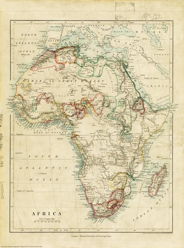
This reproduction of Stanford’s 1879 Africa Map, originally published by Edward Stanford, offers a window into the continent at a pivotal moment in history—just before the full thrust of European colonisation transformed its borders and peoples forever.
Unlike modern maps awash with colour, this piece uses detailed labelling and fine lines to convey a continent in flux: partial colonisation along the coasts, emerging administrative territories in the Sahel, and vast uncharted spaces in the interior, particularly around the Congo basin and East Africa. The names of tribes, towns, deserts, rivers (including the then-called Livingstone River), and emerging political units reveal how little was yet known—and how quickly it would change.
Latitude and longitude lines are marked at 10° intervals, adding structure to this fascinating historical document.
📜 About This Map
-
Published: 1879
-
Publisher: Edward Stanford, London
-
Subject: Africa in the early stages of colonisation, showing tribal names, geographical features, colonial possessions, and uncharted regions.
-
Size: 640 mm (W) x 860 mm (H)
-
Historical significance: A testament to how Africa was viewed and partitioned by European powers during the 19th-century scramble for empire.
🖨️ Available Finishes
We offer this historically significant map in a range of premium formats—perfect for collectors, educators, and anyone with an appreciation for Africa’s complex past.
Heavyweight Archival Paper (170 gsm FSC Matte-Coated)
-
Smooth matte finish ensures clarity and sharpness of fine lines.
-
Ideal for framing under glass in offices, libraries, or academic collections.
-
FSC-certified paper ensures sustainable sourcing while preserving the integrity of historic details.
Laminated (Encapsulated)
-
Encapsulated between two sheets of 80-micron gloss laminate.
-
Protects against UV fading, moisture, and tears—ideal for high-traffic areas, classrooms, or public exhibitions.
-
Allows for use with non-permanent markers, perfect for teaching and reference.
Archival Canvas (395 gsm HP Professional Matte)
-
Printed with pigment-based, fade-resistant inks for longevity.
-
Adds depth, warmth, and museum-quality texture.
-
Durable and robust—perfect for galleries, cultural centres, and boardrooms.
🪵 Timber Hanging Rails
For a refined finish, laminated & canvas maps can be mounted with natural timber hang rails, which include:
-
Solid timber battens lacquered in a neutral finish.
-
Pre-attached hanging cord for effortless installation—just hang on a hook.
-
A clean, gallery-style presentation that suits modern and classic interiors alike.
Please allow up to 10 working days for assembly and delivery of hang-railed maps, as they are custom-prepared by our framer.
🎯 Perfect For
-
🏛️ Museums & galleries: Highlight Africa’s transformation from colonial beginnings to modern states.
-
📚 Educators & researchers: A vital historical tool for understanding colonial geography and its impacts.
-
🏠 Home or office décor: An elegant piece celebrating Africa’s complex history—ideal for studies, libraries, or sitting rooms.
-
🎁 Gifts: A thoughtful, meaningful gift for history buffs, travellers, or map collectors.
See Africa through the eyes of the late 19th century—an era of exploration, conflict, and dramatic change. Order Stanford’s 1879 Africa Map today and own a piece of cartographic history.
Made in Australia | Premium finishes crafted to preserve and honour this historic map.


