- Australia ▾
- Topographic
▾
- Australia AUSTopo 250k (2024)
- Australia 50k Geoscience maps
- Australia 100k Geoscience maps
- Australia 250k Geoscience maps
- Australia 1.1m Geoscience maps
- New Zealand 50k maps
- New Zealand 250k maps
- New South Wales 25k maps
- New South Wales 50k maps
- New South Wales 100k maps
- Queensland 10k maps
- Queensland 25k maps
- Queensland 50k maps
- Queensland 100k maps
- Compasses
- Software
- GPS Systems
- Orienteering
- International ▾
- Wall Maps
▾
- World
- Australia & New Zealand
- Countries, Continents & Regions
- Historical
- Vintage National Geographic
- Australian Capital Territory
- New South Wales
- Northern Territory
- Queensland
- South Australia
- Tasmania
- Victoria
- Western Australia
- Celestial
- Children's
- Mining & Resources
- Wine Maps
- Healthcare
- Postcode Maps
- Electoral Maps
- Nautical ▾
- Flags
▾
- Australian Flag Sets & Banners
- Flag Bunting
- Handwavers
- Australian National Flags
- Aboriginal Flags
- Torres Strait Islander Flags
- International Flags
- Flagpoles & Accessories
- Australian Capital Territory Flags
- New South Wales Flags
- Northern Territory Flags
- Queensland Flags
- South Australia Flags
- Tasmania Flags
- Victoria Flags
- Western Australia Flags
- Gifts ▾
- Globes ▾
Dear valued customer. Please note that our checkout is not supported by old browsers. Please use a recent browser to access all checkout capabilities


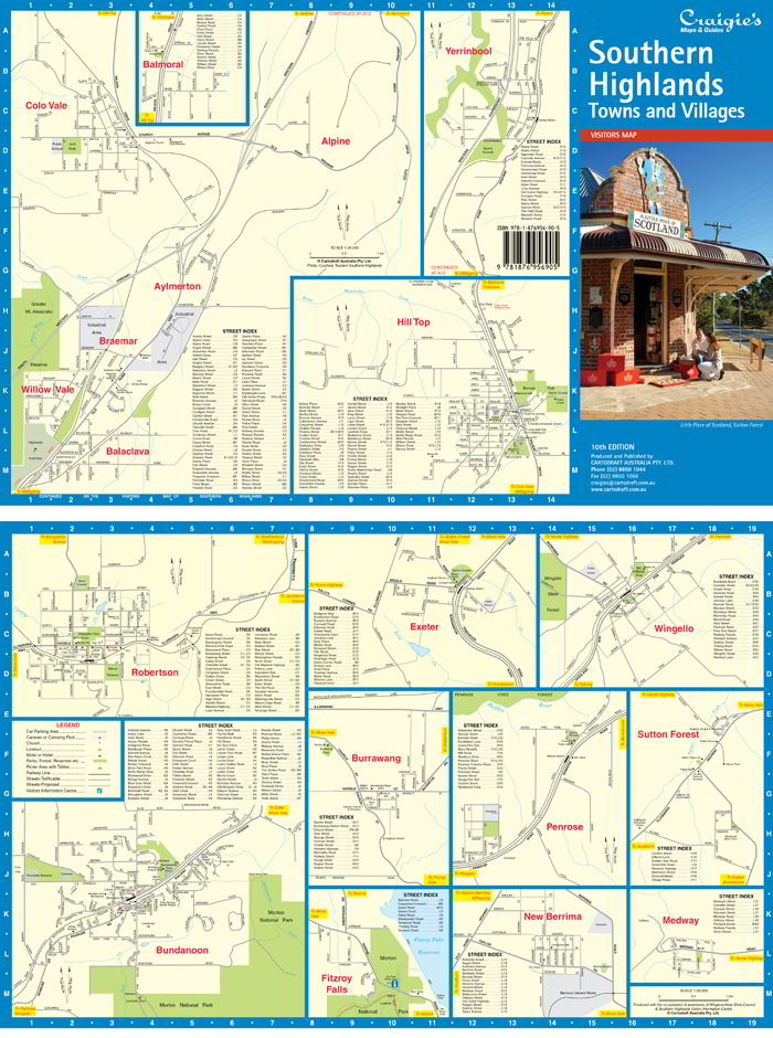
Southern Highlands Towns & Villages Craigies Map
$11.95
Afterpay is only available for orders between $50.00 and $1000.00 More info
Southern Highlands Towns & Villages Map – Craigies Maps
Detailed street-level navigation for the charming townships of New South Wales’ Southern Highlands
The Southern Highlands Towns & Villages Map by Craigies is the perfect companion to the larger Southern Highlands Regional Map, offering finely detailed street mapping of the region’s iconic small towns, rural villages, and highland hamlets.
Nestled between Sydney and Canberra, the Southern Highlands is renowned for its cool climate, rolling pastures, heritage townships, and garden villages. This map brings those communities into focus—ideal for residents, visitors, delivery services, and anyone navigating the local streets and laneways.
🌿 Coverage – Towns & Villages Included
This map includes street-level mapping for the following Southern Highlands communities:
-
Aylmerton
-
Balaclava
-
Balmoral
-
Braemar
-
Bundanoon
-
Burrawang
-
Colo Vale
-
Exeter
-
Fitzroy Falls
-
Hill Top
-
Medway
-
New Berrima
-
Penrose
-
Robertson
-
Sutton Forest
-
Willow Vale
-
Wingello
-
Yerrinbool
From the charming antique shops of Robertson to the tranquil bushland surrounds of Bundanoon and the garden estates of Exeter, this map gives you an in-depth view of local streets, public areas, and community landmarks.
🧭 Map Features
| Feature | Description |
|---|---|
| 🗺️ Street Map Scale | 1:26,000 – designed for walking, driving, and service-level navigation |
| 🏘️ Detailed Town Layouts | Includes street names, major roads, access routes, and thoroughfares |
| 🏞️ Landmarks & Facilities | Parks, schools, public halls, rail stations, cemeteries, and more |
| 📍 Clear Cartography | Clean design with easy-to-read fonts and reliable legend references |
| 🧭 Orientation Support | North arrow, distance scale, and grid for accurate reference |
| 📚 Companion to Regional Map | Designed as a supplement to the larger Craigies Southern Highlands Map |
📐 Map Specifications
| Specification | Detail |
|---|---|
| Publisher | Craigies Maps |
| Map Title | Southern Highlands Towns & Villages |
| Scale | 1:26,000 |
| Format | Folded street map |
| Coverage Area | Southern Highlands town centres and rural villages |
| Material | Durable paper stock, easy to fold and store |
| Printed in | Australia |
🎯 Ideal For
-
🛻 Delivery Drivers & Couriers navigating local street networks
-
🧭 Tourists & Visitors exploring hidden villages and countryside escapes
-
🏘️ New Residents & Home Seekers getting to know local townships
-
📚 Educators & Planners referencing detailed local layout
-
🚙 Caravaners & Road Trippers seeking more than just the main towns
-
🛒 Retailers & Service Providers with customers across the region
🌟 Why Choose a Craigies Map?
Craigies Maps are known for their clarity, reliability, and regional detail, proudly printed and published in Australia. With a legacy of trusted cartography, this local street map ensures you're always oriented—whether navigating for work, leisure, or exploration.
🧭 Navigate the Highlands with Confidence
The Southern Highlands Towns & Villages Map offers a rare and valuable level of detail across some of New South Wales’ most picturesque and historic communities. Whether you're planning a move, exploring antique trails, or delivering to rural homes and businesses, this map brings clarity and confidence to every journey.
Explore the roads less travelled. Discover the soul of the Highlands — one village at a time.


