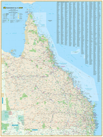
A highly detailed and region-specific map of one of Australia’s most diverse and vibrant corners — ideal for travel, planning, or display.
The South East Queensland Map by Hema Maps is an indispensable tool for anyone exploring or navigating the dynamic and varied landscapes of South East Queensland. From urban sprawl and golden beaches to rolling hinterland and quiet rural towns, this map delivers comprehensive cartographic detail alongside practical travel information — all in Hema’s signature easy-to-read format.
Whether you're a road tripper, camper, commuter, or curious local, this map provides essential coverage of the region’s highways, backroads, natural attractions, and key services. Available in folded for travel or laminated wall map format for display and planning, it’s a must-have for any glovebox, office, or classroom.
🗺️ Coverage & Regions Included
The South East Queensland Map encompasses a broad and richly populated area from the NSW–QLD border to the southern Great Barrier Reef, covering a wide variety of terrain and destinations:
-
North to Bundaberg
-
South to Ballina (NSW)
-
West to Chinchilla and the Darling Downs
-
Coastal cities and towns including:
-
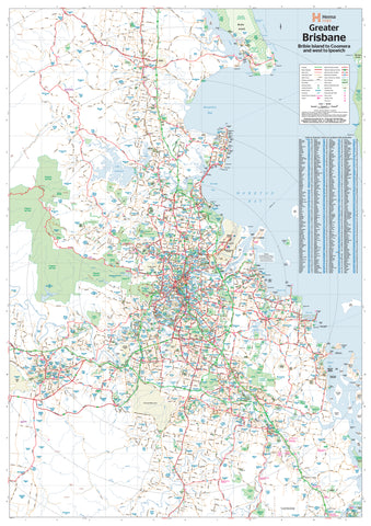
Brisbane
-
Gold Coast & Tweed Heads
-
Sunshine Coast
-
Fraser Coast (Hervey Bay & Maryborough)
-
Redlands, Ipswich, Toowoomba, Warwick, Gympie, Caboolture, and more
-
🛣️ Features & Detail
-
Road Network
-
Major highways, regional roads, tourist drives, and minor sealed/unsealed roads
-
Clear road classifications for sealed, unsealed, and 4WD-access roads
-
Distance markers and road numbers for efficient travel planning
-
-
Inset Maps
-
Brisbane City (1:30,000)
-
Brisbane Region Suburbs (1:300,000)
-
Gold Coast Urban Area
-
Sunshine Coast and Hinterland
-
-
Points of Interest
-
National parks, forests, and reserves
-
Caravan parks, campgrounds, and rest areas
-
Fuel locations, boat ramps, and tourist information centres
-
Scenic lookouts, beaches, waterfalls, heritage sites, wineries, and more
-
-
Topography & Environment
-
Hill shading and elevation data show changes in terrain
-
Coastal wetlands, river systems, and protected marine zones marked
-
Ideal for hikers, birdwatchers, and outdoor adventurers
-
-
Infrastructure
-
Railways, ferry routes, and key transport corridors
-
Airports, airstrips, and marinas
-
Key health, emergency, and access services
-
📐 Specifications
-
Scale:
-
Main Map: 1:500,000
-
Inset Maps: Brisbane Region 1:300,000, others vary by area
-
-
Sizes:
-
Folded Map: 700 mm x 1000 mm
-
Laminated Map: 700 mm x 1000 mm
-
Laminated Wall Map: 1000 mm x 1430 mm
-
-
Formats Available:
-
Folded (compact, ideal for travel)
-
Flat laminated wall map (perfect for offices, schools, and planning rooms)
-
-
Publication Date: Most recent edition (currently 2020–2023 depending on format)
-
Printed in: Australia by Hema Maps
🎯 Who Is It For?
-
Travellers touring the Gold Coast, Sunshine Coast, and hinterland regions
-
Caravanners and campers seeking facilities, access, and campsite options
-
Brisbane residents exploring weekend getaways and day trips
-
Tourism operators, councils, and visitor centres
-
Educators and students needing a detailed regional reference
-
Real estate professionals and developers mapping the SEQ growth corridor
-
Outdoor enthusiasts planning hikes, beach trips, or scenic drives
✅ Why Choose the South East Queensland Hema Map?
-
Trusted by Australians for decades — Hema’s maps are created through fieldwork and ground-truthing
-
Easy to read, with clear symbols and labelling
-
Detailed and accurate, with real-time updates from GPS and aerial data
-
Designed for both practical use and visual clarity
-
Printed and laminated in Australia, ensuring local quality
From the beach to the bush and everything in between — South East Queensland is yours to discover.
With the Hema South East Queensland Map, you're ready to plan better, explore deeper, and see more of one of Australia’s most exciting regions.
Your map. Your journey. Your Queensland.