- Australia ▾
- Topographic
▾
- Australia AUSTopo 250k (2024)
- Australia 50k Geoscience maps
- Australia 100k Geoscience maps
- Australia 250k Geoscience maps
- Australia 1.1m Geoscience maps
- New Zealand 50k maps
- New Zealand 250k maps
- New South Wales 25k maps
- New South Wales 50k maps
- New South Wales 100k maps
- Queensland 10k maps
- Queensland 25k maps
- Queensland 50k maps
- Queensland 100k maps
- Compasses
- Software
- GPS Systems
- Orienteering
- International ▾
- Wall Maps
▾
- World
- Australia & New Zealand
- Countries, Continents & Regions
- Historical
- Vintage National Geographic
- Australian Capital Territory
- New South Wales
- Northern Territory
- Queensland
- South Australia
- Tasmania
- Victoria
- Western Australia
- Celestial
- Children's
- Mining & Resources
- Wine Maps
- Healthcare
- Postcode Maps
- Electoral Maps
- Nautical ▾
- Flags
▾
- Australian Flag Sets & Banners
- Flag Bunting
- Handwavers
- Australian National Flags
- Aboriginal Flags
- Torres Strait Islander Flags
- International Flags
- Flagpoles & Accessories
- Australian Capital Territory Flags
- New South Wales Flags
- Northern Territory Flags
- Queensland Flags
- South Australia Flags
- Tasmania Flags
- Victoria Flags
- Western Australia Flags
- Gifts ▾
- Globes ▾
Dear valued customer. Please note that our checkout is not supported by old browsers. Please use a recent browser to access all checkout capabilities


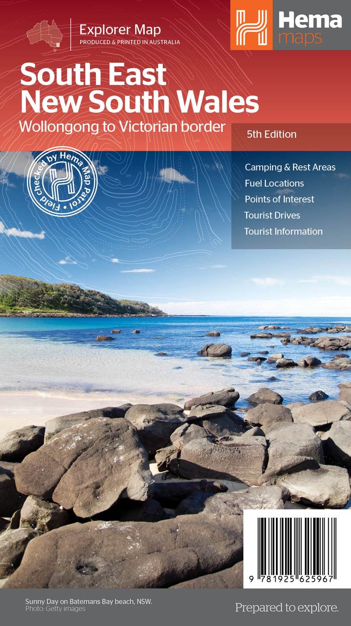
South East New South Wales Hema Map
$14.95
Afterpay is only available for orders between $50.00 and $1000.00 More info
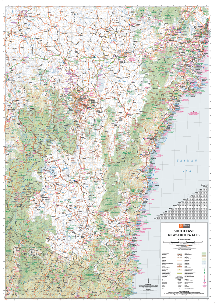
Scale: 1:375,000 | Size: 700mm (W) x 1000mm (H)
Covers Wollongong to the Victorian Border | Optional Lamination
🌿 Discover the Natural Beauty of Coastal and Country NSW
Whether you're planning a camping trip, road tour, or simply want a reliable overview of New South Wales' scenic southeast, the South East New South Wales Map by Hema is your perfect companion. Covering the region from Wollongong to the Victorian border, this map is ideal for adventurers, nature lovers, and holidaymakers exploring the South Coast, the Snowy Mountains, and the Southern Highlands.
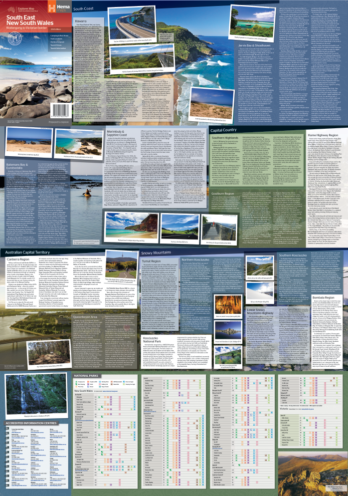
This beautifully designed, easy-to-read topographic map is part of Hema's trusted regional series and includes tourist information, photos, and points of interest, all curated with the traveller in mind.
🧭 Map Coverage Includes:
-
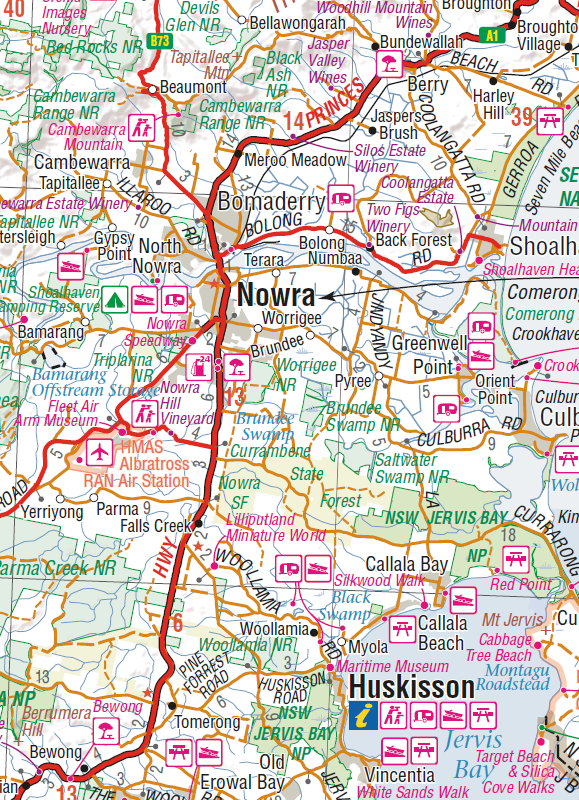
🌊 South Coast – From Wollongong to Eden, including Jervis Bay, Batemans Bay, Narooma, and Merimbula
-
🏞️ Snowy Mountains & Alpine Region – Including Cooma, Jindabyne, Thredbo & Kosciuszko National Park
-
🏡 Southern Tablelands & Highlands – Goulburn, Braidwood, Queanbeyan, Bombala, and beyond
-
🚗 Major highways, tourist drives, and scenic routes all clearly marked
📍 Features & Highlights
-
🏕️ Camping & Rest Areas – Perfect for caravanners and vanlifers
-
🌿 National Parks & Wilderness Areas – With facilities listed in detail
-
🧭 Tourist Attractions & Lookouts – Highlighted with accompanying symbols
-
📷 Full-colour photographs showcasing iconic regional destinations
-
📊 Facilities Table – National parks with amenities such as toilets, BBQs, and camping
-
⛺ Points of interest including walking trails, picnic areas, waterfalls, and historical landmarks
✅ Also available: Outback New South Wales Map – a perfect companion for inland adventurers.
✨ Laminated Version Available
Upgrade to a laminated edition to make your map adventure-proof:
-
✅ Write-on/wipe-off surface – Use whiteboard markers for trip planning and route tracking
-
✅ Compatible with map dots – Mark visited or planned destinations without damage
-
✅ Tear- and moisture-resistant – Ideal for outdoor, campsite, or planning room use
-
🛠️ Note: Laminated versions are created by flattening folded maps and encapsulating in 80-micron gloss laminate. Slight fold lines may remain visible.
📏 Product Specifications
| Feature | Details |
|---|---|
| Map Title | South East New South Wales Regional Map |
| Publisher | Hema Maps |
| Scale | 1:375,000 |
| Size | 700mm (W) x 1000mm (H) |
| Format | Folded map or laminated wall map |
| Map Features | Tourist info, national parks, photos, road network, camping areas |
| Material (Laminated Option) | 80-micron gloss laminate, writeable and reusable |
| Printed In | Australia 🇦🇺 |
🛒 Add to Cart Today
From the crashing waves of the Sapphire Coast to the snow-covered peaks of the Alpine Way, this Hema map offers clarity, detail, and inspiration for every type of traveller. A must-have for weekenders, 4WDers, hikers, and holiday planners alike.
Choose your preferred format and add to cart today – then set your compass for the stunning South East of New South Wales.


