- Australia ▾
- Topographic
▾
- Australia AUSTopo 250k (2025)
- Australia 50k Geoscience maps
- Australia 100k Geoscience maps
- Australia 250k Geoscience maps
- Australia 1:1m Geoscience maps
- New Zealand 50k maps
- New Zealand 250k maps
- New South Wales 25k maps
- New South Wales 50k maps
- New South Wales 100k maps
- Queensland 10k maps
- Queensland 25k maps
- Queensland 50k maps
- Queensland 100k maps
- Compasses
- Software
- GPS Systems
- Orienteering
- International ▾
- Wall Maps
▾
- World
- Australia & New Zealand
- Countries, Continents & Regions
- Historical
- Vintage National Geographic
- Australian Capital Territory
- New South Wales
- Northern Territory
- Queensland
- South Australia
- Tasmania
- Victoria
- Western Australia
- Celestial
- Children's
- Mining & Resources
- Wine Maps
- Healthcare
- Postcode Maps
- Electoral Maps
- Nautical ▾
- Flags
▾
- Australian Flag Sets & Banners
- Flag Bunting
- Handwavers
- Australian National Flags
- Aboriginal Flags
- Torres Strait Islander Flags
- International Flags
- Flagpoles & Accessories
- Australian Capital Territory Flags
- New South Wales Flags
- Northern Territory Flags
- Queensland Flags
- South Australia Flags
- Tasmania Flags
- Victoria Flags
- Western Australia Flags
- Gifts ▾
- Globes ▾
Dear valued customer. Please note that our checkout is not supported by old browsers. Please use a recent browser to access all checkout capabilities


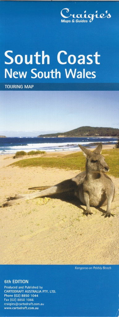
South Coast & New South Wales Craigies Map
$14.95
Afterpay is only available for orders between $50.00 and $1000.00 More info
South Coast & New South Wales Map – Craigies Maps
Comprehensive coverage from Sydney to East Gippsland, with a full state map on the reverse
The South Coast & New South Wales Map by Craigies is an essential navigation tool for travellers, planners, and businesses covering the scenic southeastern seaboard of Australia. From the vibrant city of Sydney down to the coastal town of Bairnsdale in Victoria, this map provides an expansive view of one of Australia’s most travelled regions.
On the reverse, a full New South Wales state map adds broader context, perfect for long-distance planning, logistics, or educational reference.
🌏 Regional Coverage
Main Map – South Coast Region (Scale 1:1,000,000):
-
Covers the entire coastline from Sydney in the north to Bairnsdale in the south
-
Includes major towns such as Wollongong, Nowra, Batemans Bay, Bega, Eden, and Lakes Entrance
-
Shows key inland connections and highways including the Princes Highway, Snowy Mountains Highway, and Kings Highway
-
Highlights scenic drives, regional parks, national parks, rivers, and mountain ranges
Reverse Side – New South Wales State Map (Scale 1:2,500,000):
-
Full-state overview including major cities, highways, regional centres, and transport networks
-
Ideal for road trip planning, courier and delivery logistics, and classroom or office display
🧭 Key Map Features
| Feature | Description |
|---|---|
| 🗺️ South Coast Regional Map | Scale 1:1,000,000 — balanced detail and overview from Sydney to East Gippsland |
| 📍 NSW State Map (Reverse) | Scale 1:2,500,000 — complete coverage of New South Wales for broader travel and reference |
| 🛣️ Major Roads & Highways | Pacific Highway, Princes Highway, Snowy Mountains Highway, and key inland connections |
| 🏞️ Natural Features | National Parks, rivers, escarpments, coastline, lakes, and mountain ranges |
| 🧭 Orientation Aids | Grid referencing, clear labels, and logical layout for ease of navigation |
📐 Specifications
| Specification | Detail |
|---|---|
| Publisher | Craigies Maps |
| Map Format | Folded double-sided map |
| South Coast Scale | 1:1,000,000 |
| NSW State Scale | 1:2,500,000 |
| Coverage | Sydney to Bairnsdale + full state of NSW |
| Printed in | Australia |
🎯 Perfect For
-
🚗 Road trippers and tourists exploring the South Coast and inland attractions
-
🧭 Regional planners and drivers needing clear, multi-region navigation
-
🏫 Teachers and students seeking detailed visual aids for geography and transport networks
-
🚚 Delivery services and tradespeople working across large areas of NSW and Victoria
-
🏞️ Nature lovers and campers locating national parks, beaches, and riverside retreats
🌟 Why Choose Craigies?
Trusted by locals and professionals for over 30 years, Craigies Maps deliver clear, accurate, and practical mapping for real-world travel and planning. With high legibility, durable construction, and reliable scale consistency, this South Coast & NSW Map is a must-have for anyone navigating the southeast.
From the blue waters of Jervis Bay to the lakes and forests of East Gippsland, explore the full coastline and beyond with confidence — the Craigies South Coast & NSW Map is your reliable travel companion.


