- Australia ▾
- Topographic
▾
- Australia AUSTopo 250k (2025)
- Australia 50k Geoscience maps
- Australia 100k Geoscience maps
- Australia 250k Geoscience maps
- Australia 1:1m Geoscience maps
- New Zealand 50k maps
- New Zealand 250k maps
- New South Wales 25k maps
- New South Wales 50k maps
- New South Wales 100k maps
- Queensland 10k maps
- Queensland 25k maps
- Queensland 50k maps
- Queensland 100k maps
- Western Australia 25k maps
- Western Australia 50k maps
- Western Australia 100k maps
- Compasses
- Software
- GPS Systems
- International ▾
- Wall Maps
▾
- World
- Australia & New Zealand
- Countries, Continents & Regions
- Historical
- Vintage National Geographic
- Australian Capital Territory
- New South Wales
- Northern Territory
- Queensland
- South Australia
- Tasmania
- Victoria
- Western Australia
- Celestial
- Children's
- Mining & Resources
- Wine Maps
- Healthcare
- Postcode Maps
- Electoral Maps
- Nautical ▾
- Flags
▾
- Australian Flag Sets & Banners
- Flag Bunting
- Handwavers
- Australian National Flags
- Aboriginal Flags
- Torres Strait Islander Flags
- International Flags
- Flagpoles & Accessories
- Australian Capital Territory Flags
- New South Wales Flags
- Northern Territory Flags
- Queensland Flags
- South Australia Flags
- Tasmania Flags
- Victoria Flags
- Western Australia Flags
- Gifts ▾
- Globes ▾
Dear valued customer. Please note that our checkout is not supported by old browsers. Please use a recent browser to access all checkout capabilities


Solomon Islands & South Pacific ITMB Map
$19.95
Afterpay is only available for orders between $50.00 and $1000.00 More info
Double-Sided Touring Map | WW2 History & Cruise Routes | Laminated or Paper Format
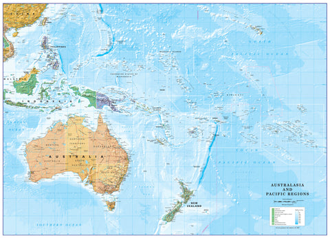
Explore one of the most beautiful and historically rich regions of the Pacific with this comprehensive Solomon Islands & South Pacific map by International Travel Maps (ITMB). This double-sided map offers both detailed local mapping and a broad overview of the South Pacific, making it ideal for travellers, history enthusiasts, cruise-goers, and classroom use.
🏝️ Side 1: Solomon Islands
The front of the map focuses on the Solomon Islands, a stunning archipelago known for its tropical beauty and pivotal role in World War II. The main mapping area includes:
-
Guadalcanal – site of one of the most significant Pacific battles of WWII
-
Inset of Honiara – the nation's capital and main port city
-
Choiseul, New Georgia, and Santa Isabel – key islands that saw fierce fighting during the war
-
Santa Cruz Islands – shown as a detailed inset
The map highlights key villages, roads, airstrips, and ferry routes across the islands. Ideal for travellers and those interested in military history, this map makes it easy to trace both modern travel routes and historical wartime movements.
🌊 Side 2: The South Pacific
The reverse side provides an ambitious and beautifully executed regional overview of the entire South Pacific:
-
Covers the region from Hawaii in the north to New Zealand in the south, and from Indonesian New Guinea to the far-flung Pitcairn Islands in the east
-
Shows international cruise ship routes, ideal for those planning island-hopping or trans-Pacific itineraries
-
Inset maps of:
-
Honolulu
-
Sydney
-
Brisbane
-
-
A unique feature of this map is the inclusion of undersea mountain ranges and sea floor features, which help explain how the Pacific islands are geologically linked — a perfect educational touch
This side of the map is particularly suited to teachers, cruise travellers, and those interested in island geography, tectonics, and navigation.
🛡️ Optional Lamination for Durability
This map can be supplied in two formats:
-
Standard paper (ideal for framing or flat use)
-
Fully laminated with high-quality 80-micron gloss film for durability:
-
Write on/wipe off with whiteboard markers
-
Use Map Dots to mark locations of interest
-
Tear- and stain-resistant for travel or classroom use
-
Note: Some light crease lines may remain if the map was previously folded before lamination
-
📐 Specifications
| Attribute | Details |
|---|---|
| Publisher | International Travel Maps (ITMB) |
| Format | Double-sided, folded or laminated |
| Primary Focus | Solomon Islands (Side 1) |
| Secondary Focus | South Pacific overview (Side 2) |
| Scale | 1:900,000 (Solomon Islands) |
| Size | 685 mm x 990 mm |
| Material | Paper or Laminated |
| Edition | Most recent edition |
Whether you're exploring WWII history, planning your next cruise, or teaching Pacific geopolitics, this versatile and richly detailed map offers clarity, quality, and a broad sense of scale across one of the world’s most culturally and geographically diverse regions.
Frequently Asked Questions
Where can I buy the Solomon Islands & South Pacific ITMB Map?
The Solomon Islands & South Pacific ITMB Map is available to buy online from Mapworld, Australia's largest map and geographic product retailer, with fast shipping Australia-wide.
Is the Solomon Islands & South Pacific ITMB Map in stock at Mapworld?
Mapworld maintains extensive stock across its map range and aims for fast dispatch. Orders placed before 2pm AEST on business days are typically dispatched the same day, with standard and express Australia-wide delivery options available.
What is Mapworld's returns policy?
Mapworld accepts returns on undamaged items in original condition. Contact Mapworld within 90 days of purchase to arrange a return or exchange.
Does Mapworld ship the Solomon Islands & South Pacific ITMB Map across Australia?
Yes, Mapworld ships Australia-wide. Standard shipping is a flat $7 rate, with free standard shipping on orders over $75. Express options are available at checkout. Most orders placed before 2pm AEST on weekdays are dispatched same day.
Related Items


© 2026 Mapworld. Website designed by Genie Media
X