- Australia ▾
- Topographic
▾
- Australia AUSTopo 250k (2024)
- Australia 50k Geoscience maps
- Australia 100k Geoscience maps
- Australia 250k Geoscience maps
- Australia 1.1m Geoscience maps
- New Zealand 50k maps
- New Zealand 250k maps
- New South Wales 25k maps
- New South Wales 50k maps
- New South Wales 100k maps
- Queensland 10k maps
- Queensland 25k maps
- Queensland 50k maps
- Queensland 100k maps
- Compasses
- Software
- GPS Systems
- Orienteering
- International ▾
- Wall Maps
▾
- World
- Australia & New Zealand
- Countries, Continents & Regions
- Historical
- Vintage National Geographic
- Australian Capital Territory
- New South Wales
- Northern Territory
- Queensland
- South Australia
- Tasmania
- Victoria
- Western Australia
- Celestial
- Children's
- Mining & Resources
- Wine Maps
- Healthcare
- Postcode Maps
- Electoral Maps
- Nautical ▾
- Flags
▾
- Australian Flag Sets & Banners
- Flag Bunting
- Handwavers
- Australian National Flags
- Aboriginal Flags
- Torres Strait Islander Flags
- International Flags
- Flagpoles & Accessories
- Australian Capital Territory Flags
- New South Wales Flags
- Northern Territory Flags
- Queensland Flags
- South Australia Flags
- Tasmania Flags
- Victoria Flags
- Western Australia Flags
- Gifts ▾
- Globes ▾
Dear valued customer. Please note that our checkout is not supported by old browsers. Please use a recent browser to access all checkout capabilities


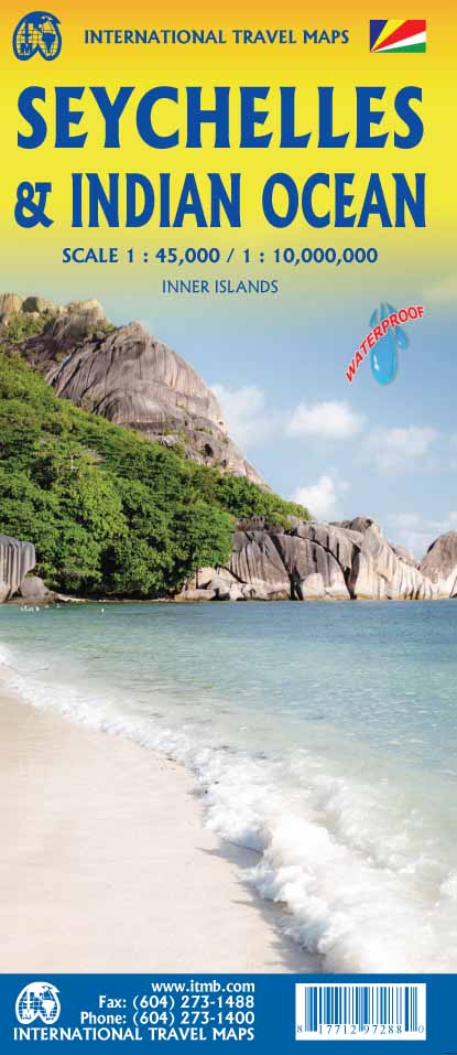
Seychelles & Indian Ocean ITMB Map
$24.95
Afterpay is only available for orders between $50.00 and $1000.00 More info
🌴 Seychelles & Indian Ocean Travel Map – ITMB Publishing
Double-sided • Seychelles Insets • Indian Ocean Political & Marine Map
Explore paradise and the world’s warmest ocean—on one extraordinary map.
This remarkable two-in-one map by ITMB Publishing brings together the lush, tropical charm of the Seychelles archipelago with an incredibly detailed first-ever map of the entire Indian Ocean. Whether you're planning a getaway to white-sand beaches or fascinated by the marine geography and politics of this vast oceanic region, this map offers both beauty and depth.
🧭 On one side: the Seychelles in detail. On the reverse: the entire Indian Ocean basin—marine ridges, island nations, and political boundaries all in one view.
🗺️ Map Features & Specifications
| Feature | Details |
|---|---|
| Regions Covered | Seychelles Islands (insets) & Indian Ocean Basin |
| Format | Double-sided, folded map |
| Publisher | ITMB (International Travel Maps, Canada) |
| Edition | First Edition |
| ISBN | 9781771294695 |
| Map Type | Political & physical with marine topography |
| Printed Size | Approx. 99 cm x 69 cm unfolded |
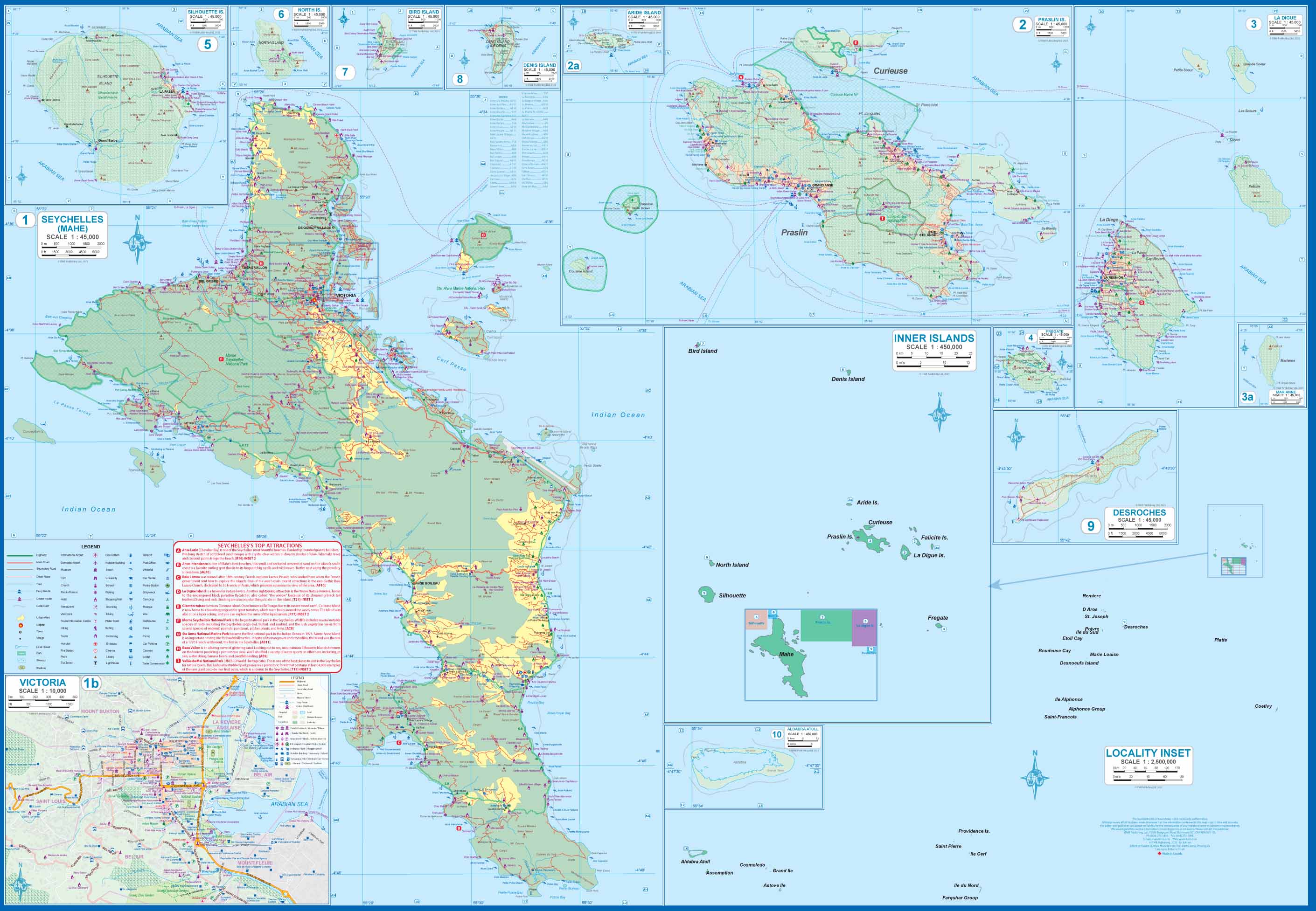
🌴 Side A: The Seychelles Archipelago
A collection of over 100 idyllic islands scattered like emeralds across the Indian Ocean, the Seychelles are captured here in vivid detail through 10 inset maps—each highlighting a key destination. With colonial French heritage, unique wildlife, and luxurious resorts, this map is the perfect guide to one of the world’s most exclusive island getaways.
🌺 Island Insets Include:
-
Mahé – Home to the capital Victoria, international airport, and many top resorts
-
Praslin – Gateway to Vallée de Mai, a UNESCO-listed palm forest
-
La Digue – Known for bicycle-friendly paths and stunning beaches
-
Curiuse, Félicité, Desroches, and more – Remote islands, each with unique charm
📍 Included Map Details:
-
Major roads and ferry routes
-
Resort locations and accommodation symbols
-
Restaurants, beaches, dive sites, parks & reserves
-
Shopping, historic landmarks, cultural attractions
-
Airports and boat terminals
🧳 Whether you’re planning a honeymoon, diving adventure, or research expedition, this side of the map offers everything you need to visualise your time in paradise.
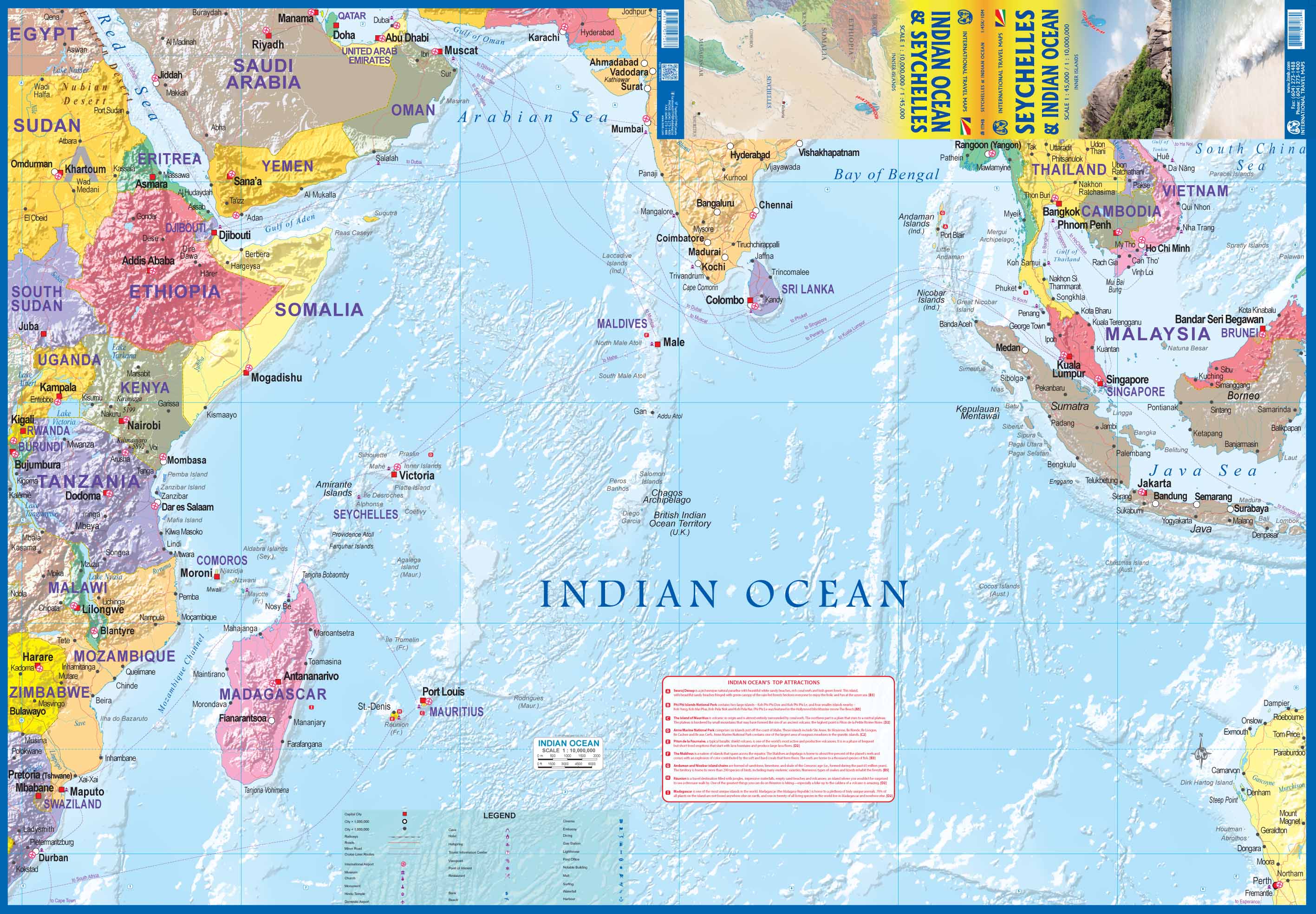
🌊 Side B: Indian Ocean Political & Marine Map
Turn the map over and you’ll find a rare cartographic overview of the Indian Ocean—a vital, yet rarely mapped, part of the world. This side combines political borders with underwater ridge systems and remote island nations that are often overlooked on world maps.
🌐 Key Features:
-
Countries shaded by political boundary: from Africa’s eastern coast to Australia’s west
-
Marine trenches and underwater ridge systems marked in shaded relief
-
Locations of major island territories and sovereign states across the ocean
🏝️ Highlighted Oceanic Nations & Territories:
-
Comoros
-
Reunion (France)
-
Maldives
-
British Indian Ocean Territory (BIOT)
-
Andaman & Nicobar Islands (India)
-
Sri Lanka, Seychelles, Madagascar, Mauritius, Indonesia and more
🧭 Ideal for visualising the geopolitical context of one of the world’s busiest shipping lanes and most strategic maritime zones.
🎒 Perfect For
| 👤 Audience | 📌 Use Case |
|---|---|
| Travellers & honeymooners | Plan an island-hopping trip to the Seychelles |
| Scuba divers & marine explorers | Identify dive zones, reefs, and ridges |
| Teachers & geography students | Understand ocean geography and nations |
| Yacht crews & marine planners | Navigate the Indian Ocean with context |
| Map collectors & travel lovers | Add a rare and detailed ocean map to your collection |
🛡️ Lamination Upgrade Available
Want to protect your map on your journey or classroom wall?
We offer a fully laminated version, encapsulated in two layers of premium 80-micron gloss laminate. It’s:
-
💧 Water-resistant
-
✍️ Writable with dry-erase markers
-
🛡️ Durable and tear-resistant for frequent use
📦 Please allow 7 business days for laminated orders, as each map is made to order.
🌟 Why Choose ITMB Maps?
-
Focused on detailed mapping of underrepresented regions
-
Designed for both travel planning and geographic education
-
Clear, practical, and beautiful enough to display
Whether you're diving into the Seychelles or navigating the wide blue between continents, this Seychelles & Indian Ocean Travel Map is your essential guide to the tropics.
🛒 Add to cart now and explore one of Earth’s most beautiful and mysterious regions—above and below the waves.


