- Australia ▾
- Topographic
▾
- Australia AUSTopo 250k (2025)
- Australia 50k Geoscience maps
- Australia 100k Geoscience maps
- Australia 250k Geoscience maps
- Australia 1:1m Geoscience maps
- New Zealand 50k maps
- New Zealand 250k maps
- New South Wales 25k maps
- New South Wales 50k maps
- New South Wales 100k maps
- Queensland 10k maps
- Queensland 25k maps
- Queensland 50k maps
- Queensland 100k maps
- Western Australia 25k maps
- Western Australia 50k maps
- Western Australia 100k maps
- Compasses
- Software
- GPS Systems
- International ▾
- Wall Maps
▾
- World
- Australia & New Zealand
- Countries, Continents & Regions
- Historical
- Vintage National Geographic
- Australian Capital Territory
- New South Wales
- Northern Territory
- Queensland
- South Australia
- Tasmania
- Victoria
- Western Australia
- Celestial
- Children's
- Mining & Resources
- Wine Maps
- Healthcare
- Postcode Maps
- Electoral Maps
- Nautical ▾
- Flags
▾
- Australian Flag Sets & Banners
- Flag Bunting
- Handwavers
- Australian National Flags
- Aboriginal Flags
- Torres Strait Islander Flags
- International Flags
- Flagpoles & Accessories
- Australian Capital Territory Flags
- New South Wales Flags
- Northern Territory Flags
- Queensland Flags
- South Australia Flags
- Tasmania Flags
- Victoria Flags
- Western Australia Flags
- Gifts ▾
- Globes ▾
Dear valued customer. Please note that our checkout is not supported by old browsers. Please use a recent browser to access all checkout capabilities


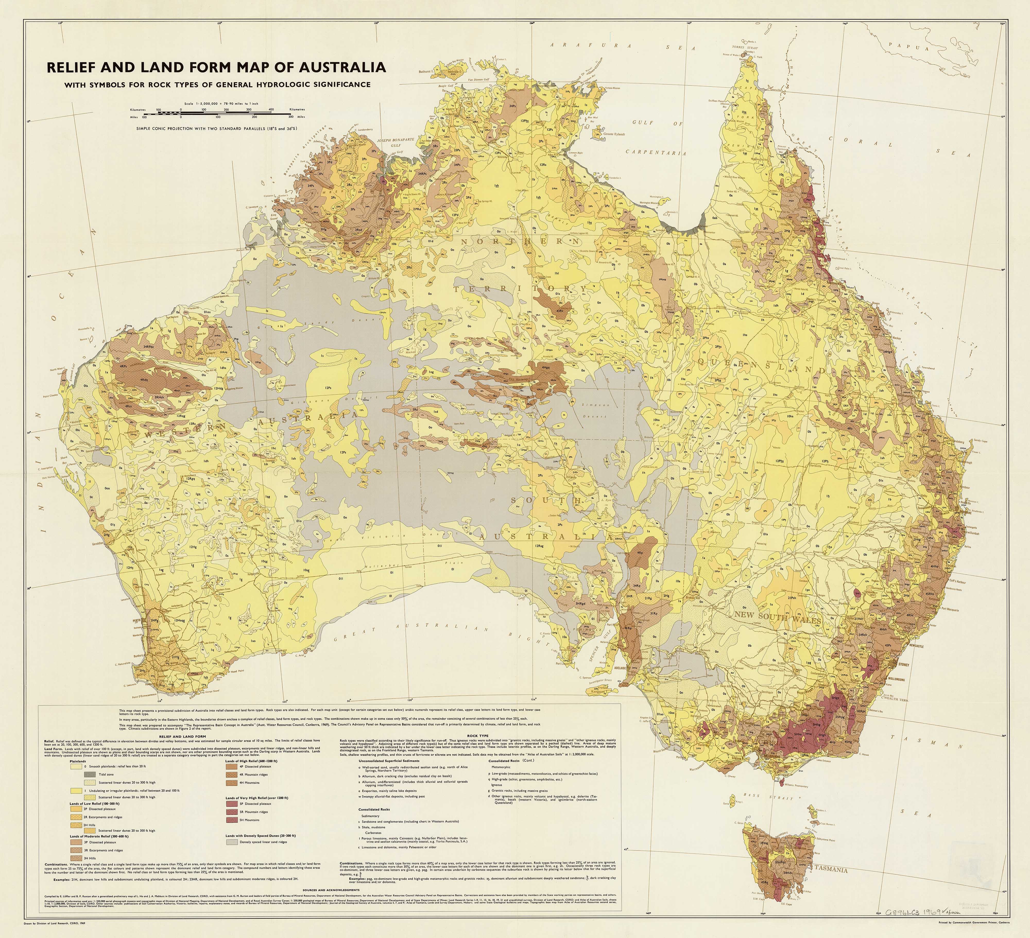
Relief and Land Form Map of Australia 1969
$59.95
or make 4 interest-free payments of
$14.99 AUD
fortnightly with
![]() More info
More info
A Landmark Cartographic Collaboration in Australian Geology and Hydrology – Now Available as a Premium Wall Map
Originally published in 1969, this Relief and Landform Map of Australia is a significant scientific and cartographic achievement, reflecting the combined efforts of Australia’s leading geographers, geologists, and hydrologists of the time. Compiled by E. Löffler and B.P. after a generalised preliminary map by L. Ho and J.A. Mabbutt of the Division of Land Research, CSIRO, the map draws on fieldwork conducted by the Bureau of Mineral Resources and support from the Australian Water Resources Council Advisory Panel on Representative Basins.
This visually arresting map shows the physical terrain of the Australian continent, highlighting relief, elevation, and key landform types, while also integrating symbols for rock types of hydrological significance—a detail that makes it valuable both as an educational tool and a collector's piece.
🗺️ Map Features
-
Shows Australia’s topography, relief, and landform regions with shaded elevation
-
Includes hydrologically significant rock types and their symbols
-
Compiled from authoritative field data by CSIRO and Bureau of Mineral Resources
-
A landmark scientific collaboration designed for use in hydrology, geography, and natural resource management
-
A rare and beautiful piece of Australian cartographic history
🖨️ Available Finishes
Choose from three premium display formats:
| Format | Description |
|---|---|
| 160gsm Paper | Ideal for framing under glass – smooth, heavyweight matte finish |
| Laminated (Encapsulated) | Sealed in dual 80-micron gloss laminate, making it highly durable, stain-resistant, and writable with whiteboard markers |
| 395gsm Canvas | Printed on HP Professional Matte Canvas using fade-resistant pigment inks – a museum-grade finish that elevates the map to a statement piece |
Optional Hang Rails (Laminated & Canvas)
Laminated & canvas editions can be mounted with natural timber hang rails, top and bottom, and come with a hanging cord already attached.
⏳ Please allow up to 10 working days for delivery of hang-railed maps, as these are individually mounted by our framer.
📐 Available Sizes
| Size Option | Dimensions |
|---|---|
| Standard | 880 mm (W) x 800 mm (H) |
| Large Format | 1100 mm (W) x 1000 mm (H) |
🧭 Specifications
| Attribute | Detail |
|---|---|
| Title | Relief and Landform Map of Australia (1969) |
| Compiled By | E. Löffler, B.P., L. Ho, J.A. Mabbutt et al. |
| Published By | CSIRO / Bureau of Mineral Resources |
| Commissioned For | Australian Water Resources Council |
| Publication Year | 1969 |
| Made In | Australia |
✅ Why Choose This Map?
| Feature | Benefit |
|---|---|
| Historical and scientific value | A rare piece of Australia's research and mapping legacy |
| Multiple size and finish options | Suitable for classrooms, study walls, offices, and map collections |
| Archival canvas option | Long-lasting, fade-resistant, and display-ready |
| Functional and decorative | Equally at home in a geology lab or heritage-inspired interior |
Whether you're a cartophile, geography educator, environmental planner, or simply appreciate the beauty of historical maps, this 1969 Relief and Landform Map of Australia is a powerful representation of Australia’s varied terrain—and the scientific collaboration that brought it to life.
Frequently Asked Questions
What are the dimensions of the Relief and Land Form Map of Australia 1969?
Mapworld wall maps range from standard 700×1000mm to large-format 1000×1430mm Supermaps. The exact dimensions for this map are shown in the product title. Where multiple sizes are available, select your preferred size when adding to cart.
Is this wall map available laminated?
Many Mapworld wall maps are available in paper, laminated, or framed finishes. Check the product options when adding to cart. Laminated maps are wipe-clean and more durable.
Is this the latest edition?
Mapworld stocks the most current editions available from all publishers. Edition year is shown in the product title where applicable. Mapworld updates its catalogue as new editions are released.
Can I write on or pin this wall map?
Laminated wall maps can be written on with whiteboard markers and wiped clean. Paper maps can be pinned on a corkboard. Choose a laminated option for a writeable surface.
Does Mapworld ship the Relief and Land Form Map of Australia 1969 across Australia?
Yes, Mapworld ships Australia-wide. Standard shipping is a flat $7 rate, with free standard shipping on orders over $75. Express options are available at checkout. Most orders placed before 2pm AEST on weekdays are dispatched same day.
Related Items


© 2026 Mapworld. Website designed by Genie Media
X