- Australia ▾
- Topographic
▾
- Australia AUSTopo 250k (2025)
- Australia 50k Geoscience maps
- Australia 100k Geoscience maps
- Australia 250k Geoscience maps
- Australia 1:1m Geoscience maps
- New Zealand 50k maps
- New Zealand 250k maps
- New South Wales 25k maps
- New South Wales 50k maps
- New South Wales 100k maps
- Queensland 10k maps
- Queensland 25k maps
- Queensland 50k maps
- Queensland 100k maps
- Compasses
- Software
- GPS Systems
- Orienteering
- International ▾
- Wall Maps
▾
- World
- Australia & New Zealand
- Countries, Continents & Regions
- Historical
- Vintage National Geographic
- Australian Capital Territory
- New South Wales
- Northern Territory
- Queensland
- South Australia
- Tasmania
- Victoria
- Western Australia
- Celestial
- Children's
- Mining & Resources
- Wine Maps
- Healthcare
- Postcode Maps
- Electoral Maps
- Nautical ▾
- Flags
▾
- Australian Flag Sets & Banners
- Flag Bunting
- Handwavers
- Australian National Flags
- Aboriginal Flags
- Torres Strait Islander Flags
- International Flags
- Flagpoles & Accessories
- Australian Capital Territory Flags
- New South Wales Flags
- Northern Territory Flags
- Queensland Flags
- South Australia Flags
- Tasmania Flags
- Victoria Flags
- Western Australia Flags
- Gifts ▾
- Globes ▾
Dear valued customer. Please note that our checkout is not supported by old browsers. Please use a recent browser to access all checkout capabilities


Polynesian Islands ITMB Map
$24.95
Afterpay is only available for orders between $50.00 and $1000.00 More info
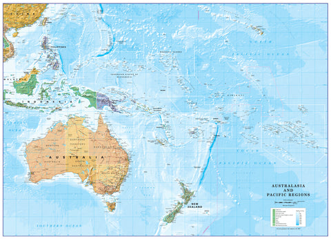
🌴 Polynesian Islands – ITMB Travel Map
Double-Sided • Regional Overview & Detailed Inset Maps • Optional Lamination for Durability
🌏 Navigate the Jewels of the South Pacific
From the lush volcanic peaks of Tahiti to the sun-kissed lagoons of Bora Bora, from the ancient mysteries of Easter Island to the sheltered harbours of Vava’u, the Polynesian Islands ITMB Map is your key to exploring one of the most captivating regions on Earth.
This expertly crafted map replaces ITMB’s much-loved Polynesian Atlas, retired due to high printing costs. In its place comes a streamlined, two-sided map that balances a broad regional perspective with precise local detail, making it equally valuable for at-home trip planning and in-the-field navigation.
🗺 Double-Sided Coverage for Complete Clarity
Side 1 – Regional Polynesia Map + Key Insets
Covers the entire sweep of Polynesia:
-
North – Hawaii’s volcanic chain.
-
South – New Zealand’s remote outliers.
-
East – Easter Island’s windswept shores.
-
West – Solomon Islands’ coral-rich waters.
Includes detailed insets of:
-
Aitutaki – Lagoon paradise of the Cook Islands.
-
Rarotonga – Cultural and transport hub of the Cooks.
-
Tongatapu – Historic heart of the Kingdom of Tonga.
-
Vava’u – A sailor’s dream, with pristine anchorages and whale encounters.
Side 2 – In-Depth Island Insets
Highlights some of the South Pacific’s most iconic destinations:
-
Samoa – Rugged coastlines, waterfalls, and rich culture.
-
Tahiti – Gateway to French Polynesia, alive with tradition and beauty.
-
Bora Bora – The "Pearl of the Pacific," famed for overwater bungalows.
-
Easter Island – Home to the legendary moai statues.
-
Moorea – Jagged peaks framed by turquoise lagoons.
-
Plus other lesser-known islands for those seeking quieter escapes.
📌 Practical Mapping Features
-
Marine and topographic details – perfect for sailors, divers, and island-hoppers.
-
Points of interest – beaches, harbours, airports, resorts, dive sites, and cultural landmarks.
-
Clear cartography – easy-to-read symbols and logical colour coding.
-
Cruiser-friendly design – ideal for multi-stop South Pacific voyages.
🛡 Lamination Upgrade – Tropical Travel Toughness
Available with professional 80-micron gloss lamination for:
-
Water resistance – ideal for boat decks, beaches, and tropical conditions.
-
Write-on/wipe-off surface for plotting with whiteboard markers.
-
Enhanced tear resistance – built to withstand heavy use.
-
Note: Laminated versions are flattened from folded maps, so slight fold lines remain visible.
📐 Product Specifications
| Feature | Detail |
|---|---|
| Publisher | ITMB – International Travel Maps |
| Edition | Latest |
| Regions Covered | Polynesia – Hawaii to New Zealand, Easter Island to Solomon Islands |
| Inset Maps | Aitutaki, Rarotonga, Tongatapu, Vava’u, Samoa, Tahiti, Bora Bora, Easter Island, Moorea |
| Scale | Varies |
| Flat Size | 1000 mm x 700 mm |
| Material | Premium paper or laminated |
| ISBN | 9781553414277 |
🎯 Who This Map Is Perfect For
-
Sailors & Yacht Cruisers – navigating island anchorages and reef systems.
-
Cruise Ship Travellers – planning shore excursions across multiple islands.
-
Adventurers & Divers – identifying marine parks and top dive spots.
-
Travel Planners – mapping dream island-hopping routes.
-
Cultural Enthusiasts – exploring Polynesia’s living traditions and archaeological treasures.
✨ Why This Map Stands Out
Unlike generic travel maps, the Polynesian Islands ITMB Map delivers both wide regional coverage and precise insets—making it the ultimate companion for South Pacific navigation and exploration.
Frequently Asked Questions
Where can I buy the Polynesian Islands ITMB Map?
The Polynesian Islands ITMB Map is available to buy online from Mapworld, Australia's largest map and geographic product retailer, with fast shipping Australia-wide.
Is the Polynesian Islands ITMB Map in stock at Mapworld?
Mapworld maintains extensive stock across its map range and aims for fast dispatch. Orders placed before 2pm AEST on business days are typically dispatched the same day, with standard and express Australia-wide delivery options available.
What is Mapworld's returns policy?
Mapworld accepts returns on undamaged items in original condition. Contact Mapworld within 90 days of purchase to arrange a return or exchange.
Does Mapworld ship the Polynesian Islands ITMB Map across Australia?
Yes, Mapworld ships Australia-wide. Standard shipping is a flat $7 rate, with free standard shipping on orders over $75. Express options are available at checkout. Most orders placed before 2pm AEST on weekdays are dispatched same day.
Related Items


© 2026 Mapworld. Website designed by Genie Media
X