- Australia ▾
- Topographic
▾
- Australia AUSTopo 250k (2024)
- Australia 50k Geoscience maps
- Australia 100k Geoscience maps
- Australia 250k Geoscience maps
- Australia 1.1m Geoscience maps
- New Zealand 50k maps
- New Zealand 250k maps
- New South Wales 25k maps
- New South Wales 50k maps
- New South Wales 100k maps
- Queensland 10k maps
- Queensland 25k maps
- Queensland 50k maps
- Queensland 100k maps
- Compasses
- Software
- GPS Systems
- Orienteering
- International ▾
- Wall Maps
▾
- World
- Australia & New Zealand
- Countries, Continents & Regions
- Historical
- Vintage National Geographic
- Australian Capital Territory
- New South Wales
- Northern Territory
- Queensland
- South Australia
- Tasmania
- Victoria
- Western Australia
- Celestial
- Children's
- Mining & Resources
- Wine Maps
- Healthcare
- Postcode Maps
- Electoral Maps
- Nautical ▾
- Flags
▾
- Australian Flag Sets & Banners
- Flag Bunting
- Handwavers
- Australian National Flags
- Aboriginal Flags
- Torres Strait Islander Flags
- International Flags
- Flagpoles & Accessories
- Australian Capital Territory Flags
- New South Wales Flags
- Northern Territory Flags
- Queensland Flags
- South Australia Flags
- Tasmania Flags
- Victoria Flags
- Western Australia Flags
- Gifts ▾
- Globes ▾
Dear valued customer. Please note that our checkout is not supported by old browsers. Please use a recent browser to access all checkout capabilities


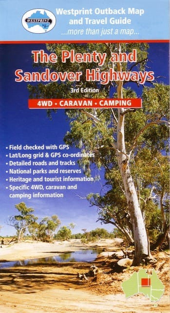
Plenty Highway Map Westprint
$13.95 $14.95
Afterpay is only available for orders between $50.00 and $1000.00 More info
Explore the Remote Heart of Australia's Red Centre — A Heritage Map for True Outback Adventurers
The Westprint Plenty Highway Map is your ultimate guide to one of Australia’s most legendary outback routes. Tailor-made for 4WD explorers, campers, and caravanners, this map covers the Plenty Highway in the Northern Territory, the full Sandover Highway, and the Diamantina Developmental Road between Birdsville and Dajarra in outback Queensland. Whether you're crossing desert plains, tracing the steps of early explorers, or heading off-grid for days at a time, this map delivers the detail, reliability, and historical richness Westprint is known for.
Part of Westprint’s renowned Heritage Map Series, this is far more than a navigation tool—it’s a cultural and historical guide to the region, with extensive background information on exploration, Aboriginal history, pioneering tracks, and natural features.
🗺️ What's Covered?
This large-format map covers key routes and regions that are rarely detailed in mainstream mapping products:
-
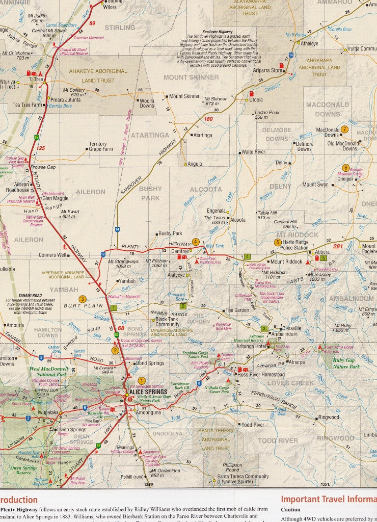
Plenty Highway – Stretching from the Stuart Highway near Alice Springs to the Queensland border at Tobermorey
-
Sandover Highway – Full route coverage, front and back of the map
-
Diamantina Developmental Road – From Birdsville in Queensland to Dajarra in the north
-
Additional outback routes connecting remote Aboriginal communities, cattle stations, and isolated roadhouses
This region is rich in desert scenery, Aboriginal culture, and pioneering exploration, and Westprint includes all the key data you’ll need to explore it safely and meaningfully.
🔍 Key Map Features
| 🔧 Feature | ✅ Description |
|---|---|
| Scale | 1:1,000,000 — offers excellent regional coverage and detail |
| Two-Sided Map | One side covers Plenty Highway and part of Sandover; the other completes the Sandover and adjacent routes |
| Field-Checked GPS Accuracy | All roads and tracks are verified in the field and GPS-referenced for confidence |
| Lat/Long Grid | Perfect for GPS navigation and traditional compass work |
| Extensive Historical Notes | Dozens of numbered locations on the map are linked to detailed background stories on the reverse, covering Aboriginal heritage, pastoral development, exploration journeys, natural features, and outback trivia |
| Explorers’ Routes Marked | Colour-coded routes show paths taken by early European explorers like Leichhardt, McKinlay, and Gregory |
| Fuel & Water Locations | Clearly marked symbols for roadhouses, 24-hour fuel, and emergency water points |
| Camping & Caravanning | Notations for rest areas, free bush camps, campgrounds, and caravan parks |
| Road Surface Classification | Visual distinctions between sealed roads, unsealed roads, and 4WD-only tracks, helping drivers of all levels choose their path confidently |
| Distance Markers | Intermediate and major distances marked between key waypoints and intersections for easy travel planning |
🧭 Extra Insights
-
Includes major rivers, creek beds, seasonal flood areas, and terrain features
-
Notes on required permits for Aboriginal lands
-
Informative “Did You Know?” boxes highlight quirky or historical facts
-
Ideal for self-reliant travel where access to online maps may be unreliable
📐 Product Specifications
| Specification | Details |
|---|---|
| Map Title | Westprint Plenty Highway & Sandover Heritage Map |
| Scale | 1:1,000,000 |
| Size (Unfolded) | 1000 mm x 700 mm |
| Format | Available folded paper or laminated (encapsulated in 80-micron gloss laminate) |
| Printed On | Heavy-duty stock for rugged field use |
| Edition | Part of the Westprint Heritage Map Series |
| ISBN | [Available on request] |
Laminated Option: Ideal for marking up with erasable whiteboard markers, sticking to caravan walls, or using on a bonnet during route planning. Extremely durable and UV resistant.
🧳 Who's It For?
-
🛻 4WD explorers heading through remote desert highways
-
🧭 Overland travellers plotting a trans-territory expedition
-
🏕️ Campers and caravanners seeking bush camps and off-grid getaways
-
📚 History buffs interested in pioneer routes and outback lore
-
🐾 Nature photographers and ecotourists travelling off the beaten track
-
🧰 Emergency planners and remote services needing accurate regional references
🌟 Why Choose Westprint?
✅ Built for the bush – maps made by outback travellers, for outback travellers
✅ Field-tested – GPS-verified and updated through real-world travel
✅ Heritage-rich – every map is part reference, part travelogue
✅ Clear & Practical – designed for real navigation, not just aesthetics
✅ Australian Made – proudly printed and published in Australia
🏞️ Summary
The Westprint Plenty Highway & Sandover Map is your go-anywhere, know-everything guide to some of Australia’s most remote and captivating regions. Combining topographic clarity with deep historical insight, it’s perfect for anyone seeking more than just a road trip—it’s a tool for adventure, education, and appreciation of Australia's vast interior.
Whether you’re heading from Alice Springs to the Queensland border, weaving through cattle country, or tracing the legacy of early outback exploration, this map will guide, inform, and inspire.
🛒 Add it to your glovebox, backpack or trip planner — and prepare for an unforgettable outback journey.


