- Australia ▾
- Topographic
▾
- Australia AUSTopo 250k (2025)
- Australia 50k Geoscience maps
- Australia 100k Geoscience maps
- Australia 250k Geoscience maps
- Australia 1:1m Geoscience maps
- New Zealand 50k maps
- New Zealand 250k maps
- New South Wales 25k maps
- New South Wales 50k maps
- New South Wales 100k maps
- Queensland 10k maps
- Queensland 25k maps
- Queensland 50k maps
- Queensland 100k maps
- Compasses
- Software
- GPS Systems
- Orienteering
- International ▾
- Wall Maps
▾
- World
- Australia & New Zealand
- Countries, Continents & Regions
- Historical
- Vintage National Geographic
- Australian Capital Territory
- New South Wales
- Northern Territory
- Queensland
- South Australia
- Tasmania
- Victoria
- Western Australia
- Celestial
- Children's
- Mining & Resources
- Wine Maps
- Healthcare
- Postcode Maps
- Electoral Maps
- Nautical ▾
- Flags
▾
- Australian Flag Sets & Banners
- Flag Bunting
- Handwavers
- Australian National Flags
- Aboriginal Flags
- Torres Strait Islander Flags
- International Flags
- Flagpoles & Accessories
- Australian Capital Territory Flags
- New South Wales Flags
- Northern Territory Flags
- Queensland Flags
- South Australia Flags
- Tasmania Flags
- Victoria Flags
- Western Australia Flags
- Gifts ▾
- Globes ▾
Dear valued customer. Please note that our checkout is not supported by old browsers. Please use a recent browser to access all checkout capabilities


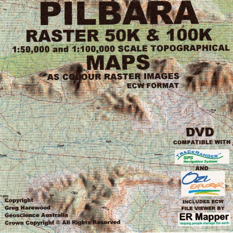
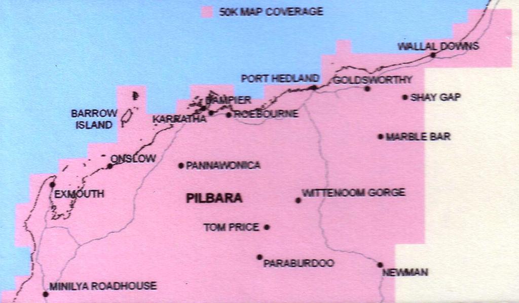
Pilbara Raster 50K Topo USB - Greg Harewood
$99.00
or make 4 interest-free payments of
$24.75 AUD
fortnightly with
![]() More info
More info
The Most Detailed Digital Mapping Resource of Western Australia’s Pilbara Region
This comprehensive USB collection delivers an exceptional topographic reference for serious explorers, land managers, GIS professionals, and 4WD adventurers venturing into the rugged expanse of the Pilbara.
Created by Greg Harewood, one of Australia's most respected topographic mappers, this collection includes 399 individual maps at a detailed 1:50,000 scale, providing unparalleled coverage and accuracy across the Pilbara region.
💾 What’s Included on the USB
| Map Content | Format |
|---|---|
| 399 x Topographic Sheets (Pilbara) | ECW and OZF |
| 1 x 100K Mosaic (Pilbara) | ECW |
| 1 x 250K Mosaic (Australia-wide) | ECW |
| Map Calibration Files | Included |
| 3D Elevation Data | 3-second (approx. 90m) spot height resolution |
All files are georeferenced and designed for compatibility with popular navigation and mapping systems.
🧭 Compatibility
The digital files are fully compatible with a wide range of GPS mapping and navigation software platforms, including:
-
Hema Navigator
-
VMS Navigation Units
-
Android Devices
-
OziExplorer / TrackRanger
-
Most GIS Mapping Systems
Whether you’re planning a remote expedition or analysing terrain for environmental or resource purposes, these maps deliver reliable, high-resolution data.
🗺️ Map Features
-
True 1:50,000 scale mapping for high-resolution terrain detail
-
3D elevation data to assist with gradient analysis and terrain visualisation
-
Ideal for off-road navigation, exploration, fieldwork, and resource management
-
Covers remote tracks, topographic features, elevations, and watercourses
-
All maps are fully calibrated for seamless integration with GPS-based mapping tools
Why Choose This Topo USB?
✔️ Field-Tested Data – Mapped by Greg Harewood, whose topographic datasets are trusted by professionals across WA’s mining, environmental, and adventure sectors
✔️ Plug-and-Play – Preloaded and ready to use straight from the USB
✔️ Australia-Wide Context – Includes full national coverage at 1:250K for planning and overlaying Pilbara data in wider context
⚙️ Technical Summary
| Specification | Detail |
|---|---|
| Coverage | Pilbara Region + Australia-wide mosaics |
| Map Scale | 1:50,000 (main), 1:100,000 & 1:250,000 (mosaics) |
| File Formats | ECW, OZF |
| Calibration | GPS Calibration Files Included |
| 3D Elevation Data | 3-sec / ~90 metre resolution |
| Media | USB Flash Drive |
Perfect For:
-
Remote 4WD Adventures
-
Topographic Surveying
-
Mining & Environmental Fieldwork
-
GIS Mapping Projects
-
Emergency and Land Services
-
Bushwalking and Exploration Enthusiasts
Unlock the hidden contours of the Pilbara. Greg Harewood’s 50K Topo USB is the essential mapping toolkit for anyone serious about navigating or working in this iconic Australian region.
Frequently Asked Questions
Where can I buy the Pilbara Raster 50K Topo USB - Greg Harewood?
The Pilbara Raster 50K Topo USB - Greg Harewood is available to buy online from Mapworld, Australia's largest map and geographic product retailer, with fast shipping Australia-wide.
Is the Pilbara Raster 50K Topo USB - Greg Harewood in stock at Mapworld?
Mapworld maintains extensive stock across its map range and aims for fast dispatch. Orders placed before 2pm AEST on business days are typically dispatched the same day, with standard and express Australia-wide delivery options available.
What is Mapworld's returns policy?
Mapworld accepts returns on undamaged items in original condition. Contact Mapworld within 90 days of purchase to arrange a return or exchange.
Does Mapworld ship the Pilbara Raster 50K Topo USB - Greg Harewood across Australia?
Yes, Mapworld ships Australia-wide. Standard shipping is a flat $7 rate, with free standard shipping on orders over $75. Express options are available at checkout. Most orders placed before 2pm AEST on weekdays are dispatched same day.
Related Items


© 2026 Mapworld. Website designed by Genie Media
X