- Australia ▾
- Topographic
▾
- Australia AUSTopo 250k (2025)
- Australia 50k Geoscience maps
- Australia 100k Geoscience maps
- Australia 250k Geoscience maps
- Australia 1:1m Geoscience maps
- New Zealand 50k maps
- New Zealand 250k maps
- New South Wales 25k maps
- New South Wales 50k maps
- New South Wales 100k maps
- Queensland 10k maps
- Queensland 25k maps
- Queensland 50k maps
- Queensland 100k maps
- Compasses
- Software
- GPS Systems
- Orienteering
- International ▾
- Wall Maps
▾
- World
- Australia & New Zealand
- Countries, Continents & Regions
- Historical
- Vintage National Geographic
- Australian Capital Territory
- New South Wales
- Northern Territory
- Queensland
- South Australia
- Tasmania
- Victoria
- Western Australia
- Celestial
- Children's
- Mining & Resources
- Wine Maps
- Healthcare
- Postcode Maps
- Electoral Maps
- Nautical ▾
- Flags
▾
- Australian Flag Sets & Banners
- Flag Bunting
- Handwavers
- Australian National Flags
- Aboriginal Flags
- Torres Strait Islander Flags
- International Flags
- Flagpoles & Accessories
- Australian Capital Territory Flags
- New South Wales Flags
- Northern Territory Flags
- Queensland Flags
- South Australia Flags
- Tasmania Flags
- Victoria Flags
- Western Australia Flags
- Gifts ▾
- Globes ▾
Dear valued customer. Please note that our checkout is not supported by old browsers. Please use a recent browser to access all checkout capabilities


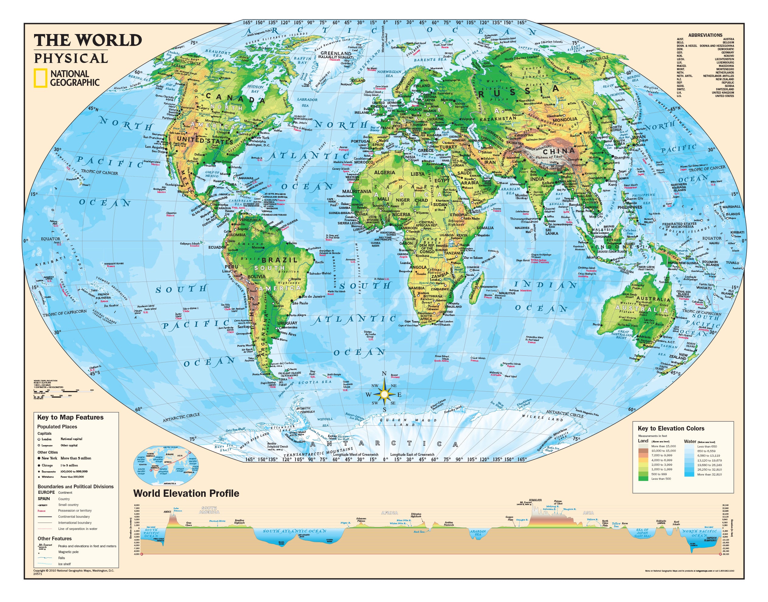
Physical World Education Wall by National Geographic 1120 x 900mm
$69.95
or make 4 interest-free payments of
$17.49 AUD
fortnightly with
![]() More info
More info
Where Cartographic Precision Meets Classroom Excellence
A trusted learning tool from one of the most respected names in geography.
Developed specifically for students in Years 4–12, this Physical World Map by National Geographic is an indispensable educational resource that brings the natural world into sharp, accurate focus. Unlike many mass-market world maps, this version employs the Winkel Tripel projection, renowned for offering the most balanced and realistic depiction of the globe.
With its clean design, clear labelling, and intuitive layout, this map helps students understand Earth’s landforms, oceans, tectonic boundaries, and elevations without distortion. Say goodbye to exaggerated poles and misleading sizes—Greenland finally looks smaller than South America, as it should.
🧭 What Makes This Map Special?
-
Educational Accuracy: Uses the Winkel Tripel projection, recommended by geographers and educators alike for its proportional balance of area, direction, and distance.
-
Designed for Years 4–12: Content and visual language tailored to young learners while remaining relevant for older students and adults.
-
Physical Geography in Detail: Clearly shows mountains, deserts, rivers, ocean currents, tectonic plate boundaries, and elevation contours—ideal for Earth science and geography curriculum.
-
Trusted Source: Produced by the National Geographic Society, an institution known worldwide for its cartographic excellence, scientific integrity, and visual clarity.
-
Visually Appealing: Soft-toned colour palette and fine detailing make this map suitable not only for learning but also for display.
📐 Map Specifications
| Feature | Details |
|---|---|
| Title | Physical World Educational Wall Map |
| Publisher | National Geographic Society |
| Projection | Winkel Tripel |
| Scale | 1:32,970,000 |
| Dimensions | 1120mm wide x 900mm high |
| Publication Date | 2010 |
| Region Coverage | Worldwide – Physical features only |
| Target Audience | School Years 4–12 (but valuable at all ages) |
Choose Your Finish – Tailored to Your Space
Whether you need a robust classroom tool, a framed centrepiece, or a long-lasting canvas display, we offer three premium finishes:
160gsm Premium Paper
-
A smooth matte finish ideal for professional framing under glass
-
Lightweight yet durable with excellent print resolution
-
A popular option for home studies, offices, and classrooms looking to frame their map
Laminated (Encapsulated Gloss)
-
Fully encapsulated between two 80-micron gloss laminate sheets
-
Waterproof and wipe-clean, perfect for hands-on learning environments
-
Long-lasting and ideal for schools, libraries, or busy family learning spaces
395gsm Matte Canvas
-
Printed on HP Professional Matte Canvas using archival pigment-based inks
-
Fade-resistant, durable, and richly textured—museum-quality finish
-
A beautiful display option for academic offices, home study walls, or school foyers
Optional Timber Hang Rails (Laminated & Canvas)
Elevate your map with hand-fitted wooden hang rails, top and bottom.
Crafted from natural lacquered timber, they add a timeless touch and a professional presentation—no framing required. A strong cord is attached to the top rail for easy hanging on a single hook or nail.
⏳ Please allow up to 10 working days for hang rail installation, as each is hand-finished by our in-house framer.
🎓 Educational Value
This map is more than decorative—it’s a pedagogical tool designed to enhance spatial awareness, physical geography comprehension, and global literacy. It aligns seamlessly with Australian and international geography curricula and makes complex concepts tangible for learners.
Ideal for lessons on:
-
Landforms and tectonic activity
-
Ocean currents and climate zones
-
Elevation and terrain comparison
-
Global physical patterns and biomes
-
Geographic literacy and map-reading skills
📦 Packaging & Delivery
-
All maps are packaged with care to ensure safe, crease-free delivery
-
Express and international shipping options available at checkout
-
Shipped from Australia
🎁 Who Is This Map For?
| Audience | Why They’ll Love It |
|---|---|
| Teachers & Schools | Adds geographic clarity and accuracy to the classroom |
| Students & Families | Makes global learning more engaging and accessible |
| Home Educators | A high-quality, curriculum-aligned visual aid |
| Libraries & Learning Centres | A bold and useful wall feature for all ages |
| Office Spaces | A sophisticated reference piece with educational value |
| Gift Buyers | A thoughtful gift for educators, students, or explorers at heart |
✅ Why Buy From Us?
-
Maps Are Our Passion – We specialise in premium, accurate wall maps and educational tools
-
Printed in Australia – Supporting local craftsmanship and high production standards
-
Outstanding Support – Have a question? Our expert team is ready to help
-
Reliable Delivery – Fast, safe, and carefully packed shipping worldwide
Bring the physical world into sharper focus.
With its educational depth, timeless design, and scientific accuracy, the National Geographic Physical World Map is a must-have for every classroom, home learning space, and geography enthusiast.
Frequently Asked Questions
What are the dimensions of the Physical World Education Wall by National Geographic 1120 x 900mm?
Mapworld wall maps range from standard 700×1000mm to large-format 1000×1430mm Supermaps. The exact dimensions for this map are shown in the product title. Where multiple sizes are available, select your preferred size when adding to cart.
Is this wall map available laminated?
Many Mapworld wall maps are available in paper, laminated, or framed finishes. Check the product options when adding to cart. Laminated maps are wipe-clean and more durable.
Is this the latest edition?
Mapworld stocks the most current editions available from all publishers. Edition year is shown in the product title where applicable. Mapworld updates its catalogue as new editions are released.
Can I write on or pin this wall map?
Laminated wall maps can be written on with whiteboard markers and wiped clean. Paper maps can be pinned on a corkboard. Choose a laminated option for a writeable surface.
Does Mapworld ship the Physical World Education Wall by National Geographic 1120 x 900mm across Australia?
Yes, Mapworld ships Australia-wide. Standard shipping is a flat $7 rate, with free standard shipping on orders over $75. Express options are available at checkout. Most orders placed before 2pm AEST on weekdays are dispatched same day.
Related Items


© 2026 Mapworld. Website designed by Genie Media
X