- Australia ▾
- Topographic
▾
- Australia AUSTopo 250k (2025)
- Australia 50k Geoscience maps
- Australia 100k Geoscience maps
- Australia 250k Geoscience maps
- Australia 1:1m Geoscience maps
- New Zealand 50k maps
- New Zealand 250k maps
- New South Wales 25k maps
- New South Wales 50k maps
- New South Wales 100k maps
- Queensland 10k maps
- Queensland 25k maps
- Queensland 50k maps
- Queensland 100k maps
- Western Australia 25k maps
- Western Australia 50k maps
- Western Australia 100k maps
- Compasses
- Software
- GPS Systems
- International ▾
- Wall Maps
▾
- World
- Australia & New Zealand
- Countries, Continents & Regions
- Historical
- Vintage National Geographic
- Australian Capital Territory
- New South Wales
- Northern Territory
- Queensland
- South Australia
- Tasmania
- Victoria
- Western Australia
- Celestial
- Children's
- Mining & Resources
- Wine Maps
- Healthcare
- Postcode Maps
- Electoral Maps
- Nautical ▾
- Flags
▾
- Australian Flag Sets & Banners
- Flag Bunting
- Handwavers
- Australian National Flags
- Aboriginal Flags
- Torres Strait Islander Flags
- International Flags
- Flagpoles & Accessories
- Australian Capital Territory Flags
- New South Wales Flags
- Northern Territory Flags
- Queensland Flags
- South Australia Flags
- Tasmania Flags
- Victoria Flags
- Western Australia Flags
- Gifts ▾
- Globes ▾
Dear valued customer. Please note that our checkout is not supported by old browsers. Please use a recent browser to access all checkout capabilities


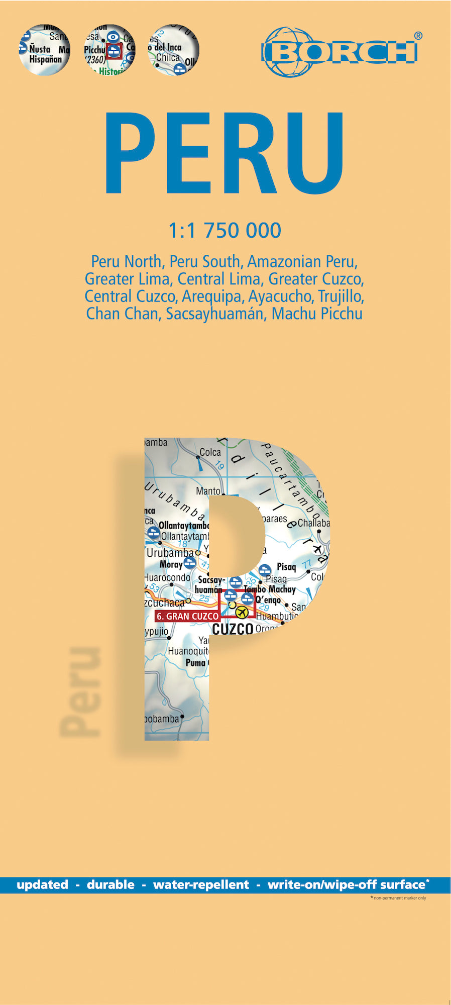
Peru Borch Folded Laminated Map
$21.95
Afterpay is only available for orders between $50.00 and $1000.00 More info
🇵🇪 Discover the Wonders of Peru with Clarity and Confidence
From the misty heights of Machu Picchu to the depths of the Amazon Basin, Peru is a land of breathtaking contrasts — and this 14th edition Borch laminated map is designed to help you navigate them all. Whether you’re trekking the Sacred Valley, exploring Lima’s historic quarters, or venturing deep into the jungle, this folded, waterproof map gives you the detailed perspective you need with the practicality of a compact format.
Laminated for durability and easy to wipe clean, the map is tear-resistant and built to endure the rigours of adventurous travel — from mountain trails to rainforest boat rides.
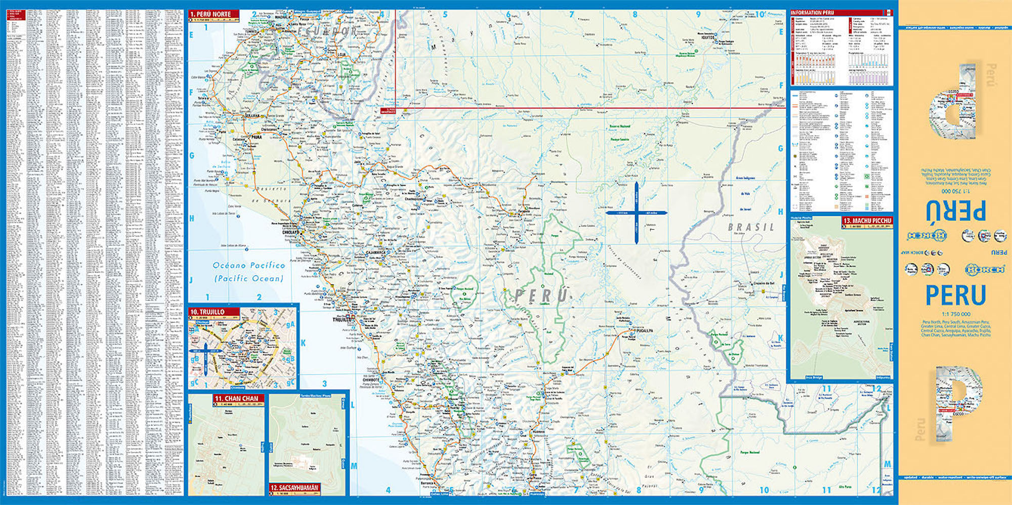
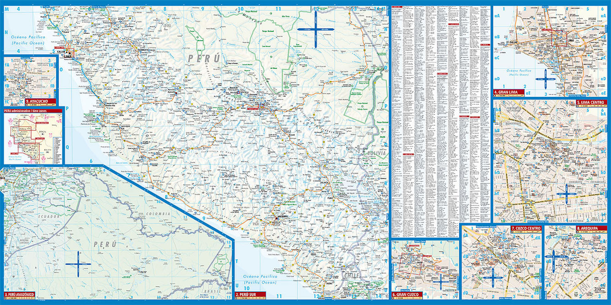
🧭 Key Map Coverage
| 🌎 Area | 📍 Scale |
|---|---|
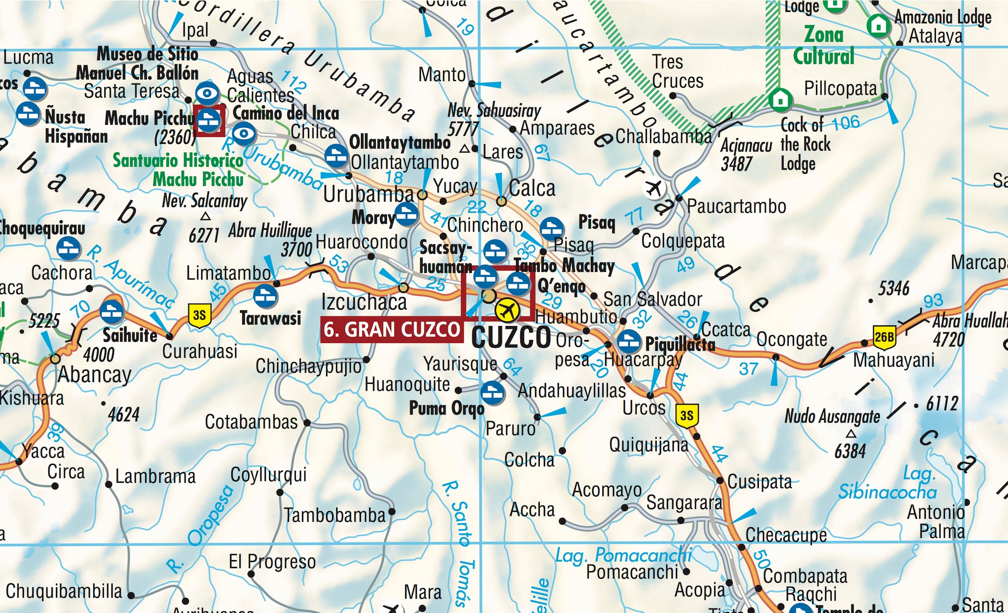
| Peru North & South | 1:1,750,000 |
| Amazonian Peru | 1:2,500,000 |
| Central Lima | 1:18,000 |
| Greater Lima | 1:150,000 |
| Central Cuzco | 1:12,000 |
| Greater Cuzco | 1:50,000 |
| Machu Picchu | 1:44,000 |
| Arequipa | 1:17,000 |
| Ayacucho | 1:20,000 |
| Trujillo | 1:20,000 |
| Chan Chan | 1:40,000 |
| Sacsayhuaman | 1:10,000 |
| Administrative Regions & Time Zones | – |
📐 Specifications
| Feature | Details |
|---|---|
| Title | Peru Borch Map |
| Scale | 1:1,750,000 (main maps) |
| ISBN | 978-3-86609-354-6 |
| Edition | 14th Edition, 2018 |
| Map Size (unfolded) | 990 mm x 494 mm (39 in x 19.5 in) |
| Folded Size | 243 mm x 110 mm x 8 mm (9.6 in x 4.3 in x 0.3 in) |
| Weight | 79 g (2.8 oz) |
| Format | Folded, soft-laminated |
| Language | Multilingual legend |
🗺️ Map Highlights
-
🌄 Topographic detail with clearly marked mountains, rivers, valleys and major natural features
-
🛤️ Road networks, railways, airports and regional connections clearly shown
-
🏛️ Cultural & archaeological sites such as Machu Picchu, Chan Chan, and Sacsayhuaman
-
🏙️ City insets provide walkable street-level mapping of major urban centres
-
📌 Tourist Points of Interest: museums, markets, hotels, parks, and ruins
-
📊 Climate Charts with average temperatures, rainfall, and sunshine hours
-
🔢 Conversion Tables for measurements, weights, and temperatures
✨ Why Choose This Map?
-
✅ Laminated for longevity – water-resistant and ideal for humid or dusty conditions
-
✅ Superb legibility – easy-to-read fonts and colour-coded elevations
-
✅ Ideal for planning routes – by car, foot, or guided tour
-
✅ Comprehensive overview of both urban centres and remote natural regions
-
✅ Lightweight and portable – perfect for your daypack or glove box
🧳 Explore Peru, Your Way
Peru is a land of soaring peaks, ancient civilizations, vibrant culture, and untamed wilderness. This map provides access to all of it:
-
🦙 Trek the Inca Trail to the sun gate of Machu Picchu
-
🐒 Navigate the dense biodiversity of Amazonian Peru
-
🏙️ Discover colonial charm in Cuzco, Lima, and Arequipa
-
🐚 Wander pre-Incan ruins like Chan Chan and Chavín
-
🐧 Visit wildlife sanctuaries near Pisco and Islas Ballestas
Whether you’re a backpacker, archaeologist, road-tripper, or culture enthusiast, this map will guide your journey with clarity, precision, and practicality.
📦 Please Note
🕐 This is an order-on-demand item. Please allow up to 10 business days for delivery.
Frequently Asked Questions
Where can I buy the Peru Borch Folded Laminated Map?
The Peru Borch Folded Laminated Map is available to buy online from Mapworld, Australia's largest map and geographic product retailer, with fast shipping Australia-wide.
Is the Peru Borch Folded Laminated Map in stock at Mapworld?
Mapworld maintains extensive stock across its map range and aims for fast dispatch. Orders placed before 2pm AEST on business days are typically dispatched the same day, with standard and express Australia-wide delivery options available.
What is Mapworld's returns policy?
Mapworld accepts returns on undamaged items in original condition. Contact Mapworld within 90 days of purchase to arrange a return or exchange.
Does Mapworld ship the Peru Borch Folded Laminated Map across Australia?
Yes, Mapworld ships Australia-wide. Standard shipping is a flat $7 rate, with free standard shipping on orders over $75. Express options are available at checkout. Most orders placed before 2pm AEST on weekdays are dispatched same day.
Related Items


© 2026 Mapworld. Website designed by Genie Media
X