- Australia ▾
- Topographic
▾
- Australia AUSTopo 250k (2025)
- Australia 50k Geoscience maps
- Australia 100k Geoscience maps
- Australia 250k Geoscience maps
- Australia 1:1m Geoscience maps
- New Zealand 50k maps
- New Zealand 250k maps
- New South Wales 25k maps
- New South Wales 50k maps
- New South Wales 100k maps
- Queensland 10k maps
- Queensland 25k maps
- Queensland 50k maps
- Queensland 100k maps
- Western Australia 25k maps
- Western Australia 50k maps
- Western Australia 100k maps
- Compasses
- Software
- GPS Systems
- International ▾
- Wall Maps
▾
- World
- Australia & New Zealand
- Countries, Continents & Regions
- Historical
- Vintage National Geographic
- Australian Capital Territory
- New South Wales
- Northern Territory
- Queensland
- South Australia
- Tasmania
- Victoria
- Western Australia
- Celestial
- Children's
- Mining & Resources
- Wine Maps
- Healthcare
- Postcode Maps
- Electoral Maps
- Nautical ▾
- Flags
▾
- Australian Flag Sets & Banners
- Flag Bunting
- Handwavers
- Australian National Flags
- Aboriginal Flags
- Torres Strait Islander Flags
- International Flags
- Flagpoles & Accessories
- Australian Capital Territory Flags
- New South Wales Flags
- Northern Territory Flags
- Queensland Flags
- South Australia Flags
- Tasmania Flags
- Victoria Flags
- Western Australia Flags
- Gifts ▾
- Globes ▾
Dear valued customer. Please note that our checkout is not supported by old browsers. Please use a recent browser to access all checkout capabilities


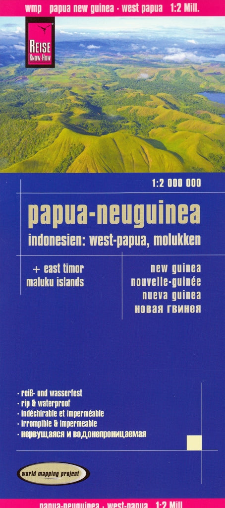
New Guinea, East Timor & Maluku Islands – Reise Know-How Folded Travel Map
$24.95
Afterpay is only available for orders between $50.00 and $1000.00 More info
Waterproof • Tear-Resistant • Double-Sided
Scale: 1:2,000,000 | Size: 1000 mm x 700 mm | Edition: World Mapping Project Series
🌍 A Comprehensive Map of a Culturally Rich and Geographically Diverse Region
This expertly detailed, double-sided travel map from Reise Know-How covers one of the most rugged and fascinating regions in the world—New Guinea, West Papua, Papua New Guinea, East Timor, and the Maluku Islands. Whether you're a traveller, researcher, overlander, or adventurer, this map provides a clear and practical overview of this vast and often under-mapped area.
🧭 Coverage Includes:
-
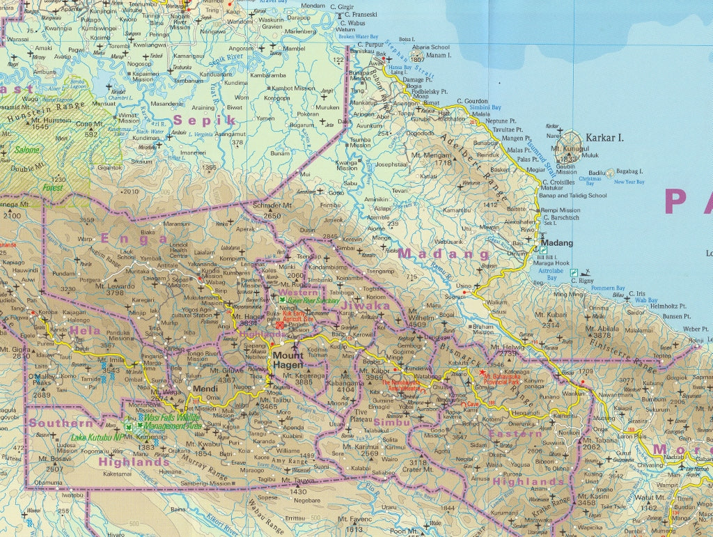
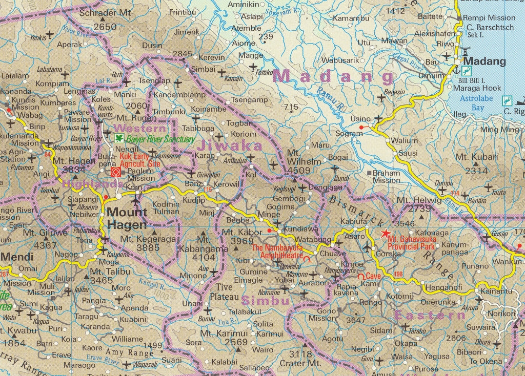
West Papua & Papua New Guinea – from Jayapura to Port Moresby, including the Sepik and Highlands regions
-
East Timor (Timor-Leste) – showing Dili, Baucau, and key regional roads
-
Maluku Islands (Moluccas) – including Ambon, Ternate, Halmahera, and Seram
-
Surrounding Indonesian Islands – with connecting ferry and air routes
🌟 Map Features
| ✔ Feature | ✅ Description |
|---|---|
| 🗺️ Double-sided cartography | Separates regions clearly while maintaining scale consistency |
| 🔍 Place name index | Extensive and easy-to-use |
| 🚙 Road network & tracks | Primary roads, unsealed routes, and 4WD tracks shown |
| 🏞️ Topography | Hypsometric tinting, contour lines & shaded relief for terrain clarity |
| 🧭 GPS-compatible | Ideal for navigation with coordinates & elevation cues |
| ✏️ Writeable surface | Can be written on with pencil despite being waterproof |
| 🧳 Detachable sleeve | Protects your map and makes folding easier on the move |
🛡️ Built for Real-World Travel
Part of Reise Know-How’s World Mapping Project, this map is:
-
✅ Printed on rip-proof, waterproof synthetic paper – perfect for humid, tropical, and wet climates
-
✅ Durable and flexible – made to withstand folding, packing, and daily use
-
✅ Weatherproof and field-tested – trusted by independent travellers and researchers alike
📐 Specifications
| Attribute | Detail |
|---|---|
| Publisher | Reise Know-How |
| Title | New Guinea, East Timor & Maluku Islands |
| Series | World Mapping Project |
| Format | Folded Map with detachable cover |
| Material | Synthetic waterproof paper |
| Scale | 1:2,000,000 |
| Sheet Size | 1000 mm x 700 mm |
| Sidedness | Double-sided |
🧭 Ideal For:
-
🌿 Independent travellers and adventurers in New Guinea and the Moluccas
-
🏕️ Backpackers, overlanders, and cultural explorers
-
🎒 Field researchers, NGOs, and development agencies
-
🗺️ Map collectors and geography educators
Explore one of the world’s last frontiers with a map designed to go wherever you do.
Frequently Asked Questions
Where can I buy the New Guinea, East Timor & Maluku Islands – Reise Know-How Folded Travel?
The New Guinea, East Timor & Maluku Islands – Reise Know-How Folded Travel is available to buy online from Mapworld, Australia's largest map and geographic product retailer, with fast shipping Australia-wide.
Is the New Guinea, East Timor & Maluku Islands – Reise Know-How Folded Travel in stock at Mapworld?
Mapworld maintains extensive stock across its map range and aims for fast dispatch. Orders placed before 2pm AEST on business days are typically dispatched the same day, with standard and express Australia-wide delivery options available.
What is Mapworld's returns policy?
Mapworld accepts returns on undamaged items in original condition. Contact Mapworld within 90 days of purchase to arrange a return or exchange.
Does Mapworld ship the New Guinea, East Timor & Maluku Islands – Reise Know-How Folded Travel across Australia?
Yes, Mapworld ships Australia-wide. Standard shipping is a flat $7 rate, with free standard shipping on orders over $75. Express options are available at checkout. Most orders placed before 2pm AEST on weekdays are dispatched same day.
Related Items


© 2026 Mapworld. Website designed by Genie Media
X