- Australia ▾
- Topographic
▾
- Australia AUSTopo 250k (2025)
- Australia 50k Geoscience maps
- Australia 100k Geoscience maps
- Australia 250k Geoscience maps
- Australia 1.1m Geoscience maps
- New Zealand 50k maps
- New Zealand 250k maps
- New South Wales 25k maps
- New South Wales 50k maps
- New South Wales 100k maps
- Queensland 10k maps
- Queensland 25k maps
- Queensland 50k maps
- Queensland 100k maps
- Compasses
- Software
- GPS Systems
- Orienteering
- International ▾
- Wall Maps
▾
- World
- Australia & New Zealand
- Countries, Continents & Regions
- Historical
- Vintage National Geographic
- Australian Capital Territory
- New South Wales
- Northern Territory
- Queensland
- South Australia
- Tasmania
- Victoria
- Western Australia
- Celestial
- Children's
- Mining & Resources
- Wine Maps
- Healthcare
- Postcode Maps
- Electoral Maps
- Nautical ▾
- Flags
▾
- Australian Flag Sets & Banners
- Flag Bunting
- Handwavers
- Australian National Flags
- Aboriginal Flags
- Torres Strait Islander Flags
- International Flags
- Flagpoles & Accessories
- Australian Capital Territory Flags
- New South Wales Flags
- Northern Territory Flags
- Queensland Flags
- South Australia Flags
- Tasmania Flags
- Victoria Flags
- Western Australia Flags
- Gifts ▾
- Globes ▾
Dear valued customer. Please note that our checkout is not supported by old browsers. Please use a recent browser to access all checkout capabilities
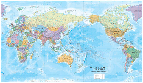
Pacific Centred World Time Zone Wall Map 1022 x 595mm
$69.95
or make 4 interest-free payments of
$17.49 AUD
fortnightly with
![]() More info
More info
🌏 Pacific-Centred World Time Zone Wall Map — 1022 × 595mm
A vibrant and practical world reference designed for anyone who works, studies, or travels across multiple time zones. Centred on the vast Pacific Ocean, this beautifully produced map seamlessly blends detailed political cartography with contrasting vertical colour bands that clearly represent time zones across continents and oceans.
This Pacific-centred perspective is ideal for those in Australia, New Zealand, Asia, and the Americas, showing the Pacific Rim as the central focus and providing a natural view for trans-Pacific business and travel planning.
🗺 Key Features
-
🕒 Time Zones at a Glance — Distinct colour bands for each time zone, labelled for quick reference.
-
🌐 Political & Geographic Detail — Includes countries, capitals, major cities, boundaries, and key physical features.
-
🌊 Pacific-Centred Projection — Ideal for Pacific Rim users and global trade routes.
-
📊 Daylight Saving Reference — Inset chart detailing countries and states that observe daylight saving hours.
-
🖋 Expert Cartography — Clear labelling ensures legibility without crowding the map.
📏 Specifications
| Feature | Details |
|---|---|
| Size | 1022 mm (W) × 595 mm (H) |
| Scale | 1:40,000,000 |
| Projection | Pacific-Centred |
| Finish Options | Paper, Laminated, Laminated with Hang Rails, Canvas, Canvas with Hang Rails |
| Country of Manufacture | Made in Australia |
🎨 Format & Finish Options
Choose the style and durability that best suit your space:
-
📄 Heavyweight Paper (160gsm) — Crisp, sharp print; perfect for framing under glass.
-
💧 Laminated — Encapsulated with two layers of 80-micron gloss laminate; durable, wipe-clean, and suitable for whiteboard markers.
-
🖼 Laminated with Hang Rails — Ready-to-hang with natural timber rails and cord for a polished finish.
-
🖌 Premium Canvas (395gsm HP Professional Matte) — Textured, museum-grade surface with fade-resistant pigment inks for long-term display.
-
🖌 Canvas with Hang Rails — A luxury, ready-to-hang version combining rich canvas texture with elegant timber rails.
⏳ Lead Time: Please allow up to 10 working days for hang-railed maps as these are custom-mounted by our framer.
💡 Perfect For
-
📊 International Businesses — Schedule meetings across Pacific and global time zones.
-
🏫 Classrooms & Universities — Teach global geography with an engaging visual tool.
-
✈️ Travellers & Cruise Planners — Plan routes across Asia, Oceania, and the Americas.
-
🎁 Gift Buyers — A practical and decorative present for executives, teachers, or world travellers.
📜 Why Choose This Pacific-Centred Map
This projection places the Pacific Ocean — and the nations surrounding it — at the heart of the map. This makes it particularly valuable for Australian, New Zealand, and Pacific-based users, as well as for those working in trans-Pacific trade, aviation, or communications.
With its compact 1022 × 595mm size, it fits perfectly in home offices, study areas, meeting rooms, or travel agency walls, offering an immediate visual reference without overwhelming the space.
➡ Order today for a functional, beautifully presented, and internationally relevant addition to your wall.


