- Australia ▾
- Topographic
▾
- Australia AUSTopo 250k (2025)
- Australia 50k Geoscience maps
- Australia 100k Geoscience maps
- Australia 250k Geoscience maps
- Australia 1:1m Geoscience maps
- New Zealand 50k maps
- New Zealand 250k maps
- New South Wales 25k maps
- New South Wales 50k maps
- New South Wales 100k maps
- Queensland 10k maps
- Queensland 25k maps
- Queensland 50k maps
- Queensland 100k maps
- Western Australia 25k maps
- Western Australia 50k maps
- Western Australia 100k maps
- Compasses
- Software
- GPS Systems
- International ▾
- Wall Maps
▾
- World
- Australia & New Zealand
- Countries, Continents & Regions
- Historical
- Vintage National Geographic
- Australian Capital Territory
- New South Wales
- Northern Territory
- Queensland
- South Australia
- Tasmania
- Victoria
- Western Australia
- Celestial
- Children's
- Mining & Resources
- Wine Maps
- Healthcare
- Postcode Maps
- Electoral Maps
- Nautical ▾
- Flags
▾
- Australian Flag Sets & Banners
- Flag Bunting
- Handwavers
- Australian National Flags
- Aboriginal Flags
- Torres Strait Islander Flags
- International Flags
- Flagpoles & Accessories
- Australian Capital Territory Flags
- New South Wales Flags
- Northern Territory Flags
- Queensland Flags
- South Australia Flags
- Tasmania Flags
- Victoria Flags
- Western Australia Flags
- Gifts ▾
- Globes ▾
Dear valued customer. Please note that our checkout is not supported by old browsers. Please use a recent browser to access all checkout capabilities


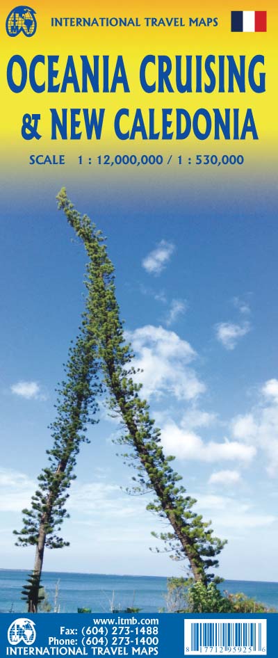
New Caledonia & Oceania Cruising Map – ITMB
$24.95
Afterpay is only available for orders between $50.00 and $1000.00 More info
Double-Sided Folded Travel & Cruise Map
Scale: Varies | Size: 685 mm x 990 mm | Format: Paper (lamination optional)
🌴 Explore the South Pacific – From Island Shores to Open Sea
This beautifully rendered, double-sided map by International Travel Maps (ITMB) is your essential guide to New Caledonia and the broader cruising region of Oceania. Designed for travellers, adventurers, and cruise ship passengers alike, this map combines detailed local cartography with a sweeping overview of the entire South Pacific—from the remote Loyalty Islands to the bustling ports of Sydney and Honolulu.
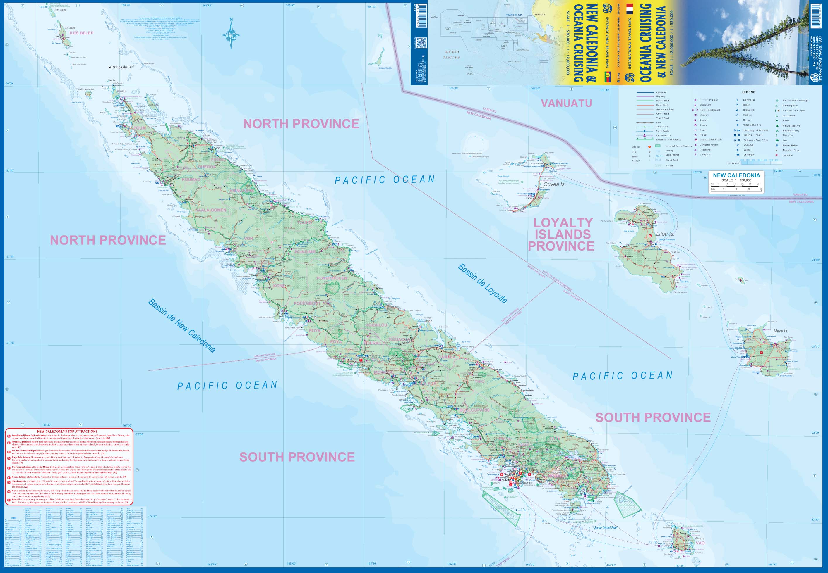
🧭 Side One: New Caledonia & the Loyalty Islands
-
Main Island Coverage: Grande Terre is shown in detail, including the capital Nouméa, national highways, smaller roads, villages, resorts, and points of interest.
-
Loyalty Islands Included: Lifou, Maré, Ouvéa, and Tiga – key highlights for divers, eco-tourists, and cultural explorers.
-
WWII Historical Significance: Strategic military importance noted, with locations that played a role during the war.
-
Resorts and Urban Infrastructure: Road network linking coastal towns, beaches, and the capital, along with resort icons.
-
French Overseas Territory: Shows regional divisions, marine parks, and French place names.
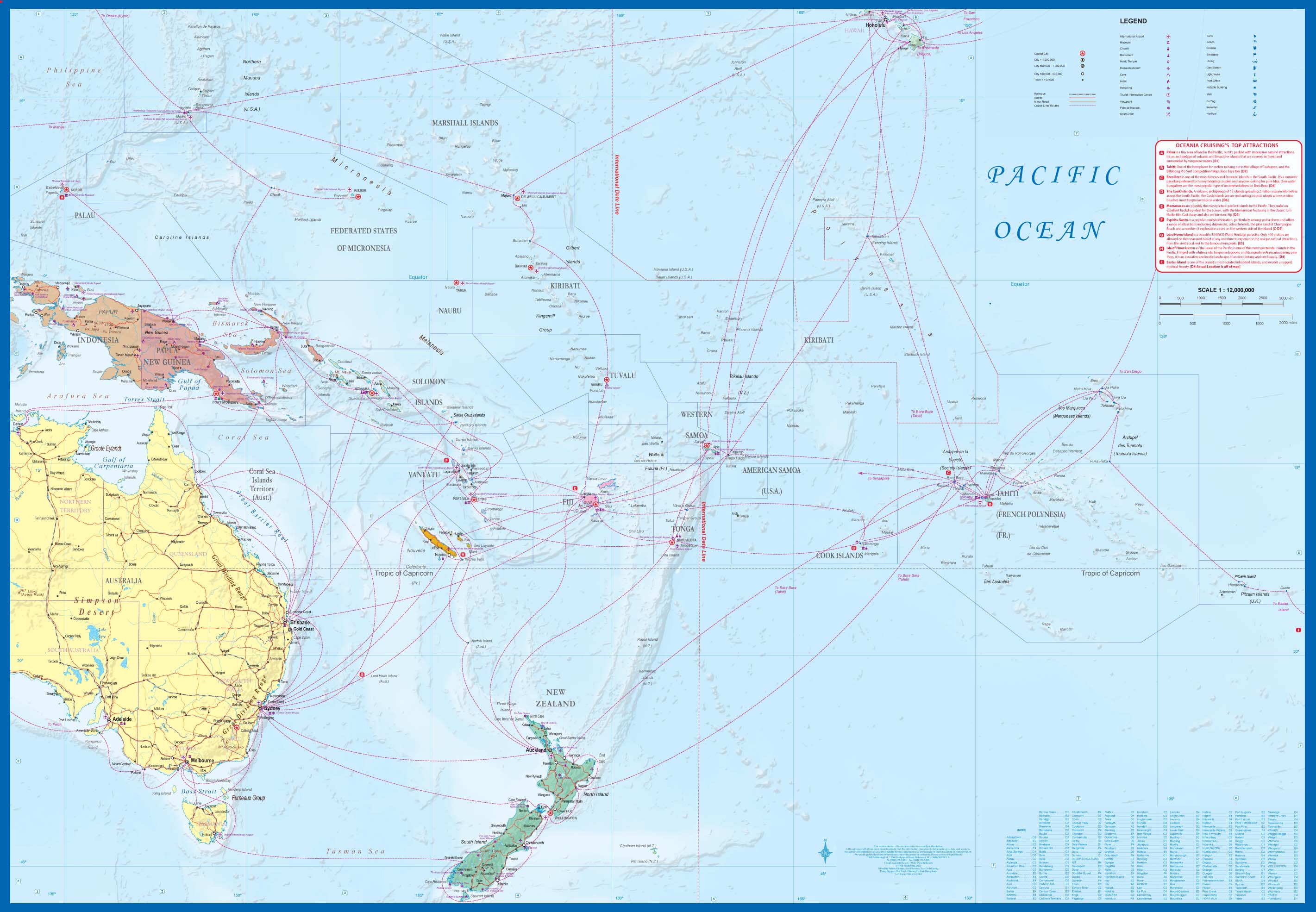
🌊 Side Two: Oceania – South Pacific Cruising Map
Covering the entire cruising corridor of the South Pacific, this side offers a rare regional view ideal for:
-
Cruise planning from Australia, New Zealand, and Hawaii
-
Island hopping and yacht navigation
-
Educational use for understanding geography, island nations, and maritime routes
Includes:
| Region / Feature | Covered |
|---|---|
| 🏝️ Hawaii to the Marianas | Including Guam and Micronesia |
| 🇦🇺 Eastern Australia | Sydney, Brisbane, Cairns |
| 🇳🇿 All of New Zealand | North and South Islands |
| 🇼🇸 Samoa, American Samoa, Fiji, Tonga | Central Polynesia |
| 🇹🇻 Tuvalu, Kiribati, Marshall Islands | North-central Pacific |
| 🇨🇰 Cook Islands & French Polynesia | Including Tahiti and Bora Bora |
| 🌐 Major cruise routes | With port cities and key sea lanes |
🌟 Key Features
-
✅ Double-sided: Local map + regional oceanic overview
-
✅ Cruise and tourism focused: Resorts, harbours, and touristic highlights marked
-
✅ Political boundaries and major cities included
-
✅ Extensive indexing: Easy reference to place names
-
✅ Printed on quality paper for clarity and colour
🛡️ Optional Lamination Available
Want a map that can handle more than a sea breeze?
-
✍️ Write-on/wipe-off surface (great for cruise planning or classroom use)
-
💧 Water-resistant & tear-proof with 80-micron gloss laminate
-
🎯 Map dots & whiteboard markers can be used without damaging the surface
Laminated maps are made by carefully flattening the folded map and encapsulating it in a protective layer. Note: slight fold lines may still be visible due to the original format.
We also offer:
-
Canvas printing on 395gsm matte canvas with pigment inks
-
Timber hang rails (allow 10 working days for framed delivery)
📐 Specifications
| Attribute | Detail |
|---|---|
| Publisher | International Travel Maps (ITMB) |
| Title | New Caledonia & Oceania Cruising Map |
| Format | Folded paper (laminated & canvas options available) |
| Printed Area | 685 mm x 990 mm |
| Scale | Varies by region |
| Sidedness | Double-sided (New Caledonia / South Pacific) |
🧳 Ideal For:
-
🌊 Cruise passengers & planners exploring South Pacific routes
-
✈️ Australians & New Zealanders vacationing in Nouméa or the Loyalty Islands
-
🗺️ Travel agents and tourism operators
-
🏫 Educators and students studying Pacific geography
-
🌍 Map collectors and globetrotters
✈️ Travel Tip:
New Caledonia is an increasingly popular getaway for travellers from Australia, New Zealand, and France—offering crystal-clear lagoons, colonial architecture, and laid-back island culture, just a short flight or cruise away.
Frequently Asked Questions
Where can I buy the New Caledonia & Oceania Cruising Map – ITMB?
The New Caledonia & Oceania Cruising Map – ITMB is available to buy online from Mapworld, Australia's largest map and geographic product retailer, with fast shipping Australia-wide.
Is the New Caledonia & Oceania Cruising Map – ITMB in stock at Mapworld?
Mapworld maintains extensive stock across its map range and aims for fast dispatch. Orders placed before 2pm AEST on business days are typically dispatched the same day, with standard and express Australia-wide delivery options available.
What is Mapworld's returns policy?
Mapworld accepts returns on undamaged items in original condition. Contact Mapworld within 90 days of purchase to arrange a return or exchange.
Does Mapworld ship the New Caledonia & Oceania Cruising Map – ITMB across Australia?
Yes, Mapworld ships Australia-wide. Standard shipping is a flat $7 rate, with free standard shipping on orders over $75. Express options are available at checkout. Most orders placed before 2pm AEST on weekdays are dispatched same day.
Related Items


© 2026 Mapworld. Website designed by Genie Media
X