- Australia ▾
- Topographic
▾
- Australia AUSTopo 250k (2025)
- Australia 50k Geoscience maps
- Australia 100k Geoscience maps
- Australia 250k Geoscience maps
- Australia 1:1m Geoscience maps
- New Zealand 50k maps
- New Zealand 250k maps
- New South Wales 25k maps
- New South Wales 50k maps
- New South Wales 100k maps
- Queensland 10k maps
- Queensland 25k maps
- Queensland 50k maps
- Queensland 100k maps
- Compasses
- Software
- GPS Systems
- Orienteering
- International ▾
- Wall Maps
▾
- World
- Australia & New Zealand
- Countries, Continents & Regions
- Historical
- Vintage National Geographic
- Australian Capital Territory
- New South Wales
- Northern Territory
- Queensland
- South Australia
- Tasmania
- Victoria
- Western Australia
- Celestial
- Children's
- Mining & Resources
- Wine Maps
- Healthcare
- Postcode Maps
- Electoral Maps
- Nautical ▾
- Flags
▾
- Australian Flag Sets & Banners
- Flag Bunting
- Handwavers
- Australian National Flags
- Aboriginal Flags
- Torres Strait Islander Flags
- International Flags
- Flagpoles & Accessories
- Australian Capital Territory Flags
- New South Wales Flags
- Northern Territory Flags
- Queensland Flags
- South Australia Flags
- Tasmania Flags
- Victoria Flags
- Western Australia Flags
- Gifts ▾
- Globes ▾
Dear valued customer. Please note that our checkout is not supported by old browsers. Please use a recent browser to access all checkout capabilities


Nowra & District Craigies Map
$14.95
Afterpay is only available for orders between $50.00 and $1000.00 More info
Nowra & District Map – Craigies Maps
Your trusted navigation tool for exploring Nowra, Bomaderry, and the surrounding Shoalhaven region
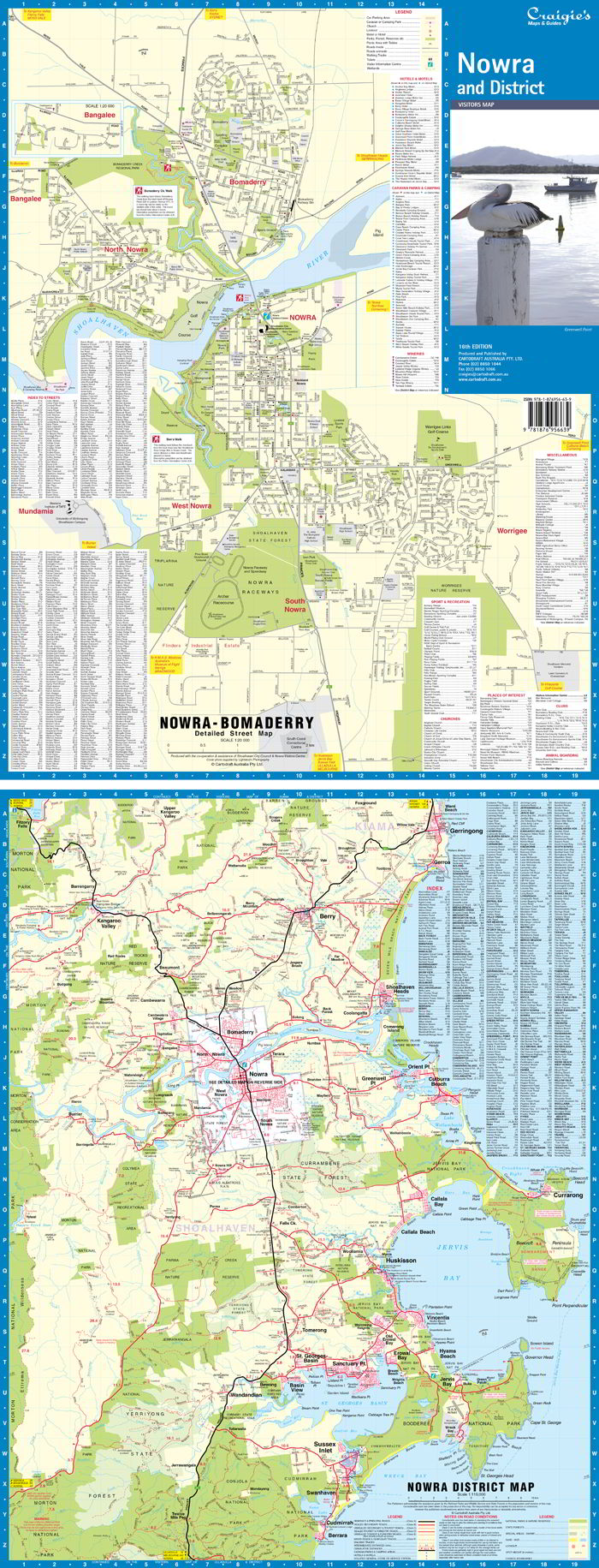
Whether you're a resident, visitor, or road-tripper heading through the scenic South Coast of New South Wales, the Craigies Nowra & District Map is an essential resource for navigating this vibrant and diverse region. With comprehensive coverage from Gerringong and Kangaroo Valley in the north, to Cudmirrah in the south, and west to Morton National Park, this map combines regional clarity with detailed urban street mapping.
Designed for ease of use, this dual-scale map is perfect for tourists, locals, business travellers, and delivery drivers alike.
🌿 Regional Coverage Highlights
The Nowra & District Map spans a wide and popular stretch of the NSW South Coast, capturing the junction of coastal charm, rural farmland, and pristine bushland. Key locations within the map include:
-
🏙️ Nowra & Bomaderry – with full street-level mapping
-
🌲 Morton National Park – for bushwalking, camping, and scenic drives
-
🏞️ Kangaroo Valley – a beloved destination for outdoor recreation and heritage tourism
-
🌊 Shoalhaven River & Jervis Bay vicinity
-
🏖️ South Coast beaches, including Cudmirrah and Sussex Inlet
Whether you're exploring historic town centres, planning outdoor adventures, or tracing local backroads, this map offers the guidance you need.
🧭 Map Features
| Feature | Description |
|---|---|
| 🗺️ District Map Scale | 1:110,000 – Ideal for broad regional planning |
| 🏘️ Street Map Scale | 1:20,000 – High detail for urban navigation in Nowra & Bomaderry |
| 🛣️ Road Networks | Covers major roads, minor roads, and access routes to regional attractions |
| 🏞️ Natural Features | Includes rivers, forests, national parks, and reserves |
| 🧭 Orientation Tools | Clearly marked grid references and map legends for easy use |
| 🏕️ Points of Interest | Parks, lookouts, community facilities, and more |
| 🧳 Visitor-Friendly Layout | Great for planning sightseeing, travel routes, or local excursions |
📐 Map Specifications
| Detail | Specification |
|---|---|
| Publisher | Craigies Maps |
| Map Title | Nowra & District |
| Street Map Scale | 1:20,000 |
| District Map Scale | 1:110,000 |
| Coverage Area | Gerringong, Kangaroo Valley, Cudmirrah, Morton National Park |
| Format | Folded regional and street map |
| Printed Size | Large-format for clarity and legibility |
| Weight | Lightweight and portable – perfect for glovebox or travel pack |
🎯 Perfect For
-
🚗 Self-drive tourists exploring the Shoalhaven and South Coast region
-
🏡 Local residents needing a reliable map of Nowra and surrounds
-
🛻 Delivery drivers and tradies requiring detailed road and street layouts
-
🏕️ Campers and adventurers visiting Kangaroo Valley and Morton National Park
-
📚 Students and educators studying local geography or planning field trips
-
🧳 Holidaymakers and weekenders heading to South Coast beach towns
🌟 Why Choose Craigies Maps?
For decades, Craigies Maps has been producing practical and dependable maps tailored to Australia's unique landscape and travel needs. This Nowra & District edition is:
-
✔️ Locally relevant and up-to-date
-
✔️ Clear and easy to read
-
✔️ Ideal for both planning and in-field reference
-
✔️ Australian-made cartographic quality
🧭 Navigate with Confidence
From river crossings and forest trails to seaside towns and national parks, the Craigies Nowra & District Map gives you the detail you need and the confidence to explore further. Whether you’re planning your next escape, navigating day-to-day routes, or simply discovering new corners of the Shoalhaven, this map is the perfect companion.
Discover the beauty, history, and hidden gems of the Nowra region — with Craigies at your side.
Frequently Asked Questions
Where can I buy the Nowra & District Craigies Map?
The Nowra & District Craigies Map is available to buy online from Mapworld, Australia's largest map and geographic product retailer, with fast shipping Australia-wide.
Is the Nowra & District Craigies Map in stock at Mapworld?
Mapworld maintains extensive stock across its map range and aims for fast dispatch. Orders placed before 2pm AEST on business days are typically dispatched the same day, with standard and express Australia-wide delivery options available.
What is Mapworld's returns policy?
Mapworld accepts returns on undamaged items in original condition. Contact Mapworld within 90 days of purchase to arrange a return or exchange.
Does Mapworld ship the Nowra & District Craigies Map across Australia?
Yes, Mapworld ships Australia-wide. Standard shipping is a flat $7 rate, with free standard shipping on orders over $75. Express options are available at checkout. Most orders placed before 2pm AEST on weekdays are dispatched same day.
Related Items


© 2026 Mapworld. Website designed by Genie Media
X