- Australia ▾
- Topographic
▾
- Australia AUSTopo 250k (2025)
- Australia 50k Geoscience maps
- Australia 100k Geoscience maps
- Australia 250k Geoscience maps
- Australia 1:1m Geoscience maps
- New Zealand 50k maps
- New Zealand 250k maps
- New South Wales 25k maps
- New South Wales 50k maps
- New South Wales 100k maps
- Queensland 10k maps
- Queensland 25k maps
- Queensland 50k maps
- Queensland 100k maps
- Western Australia 25k maps
- Western Australia 50k maps
- Western Australia 100k maps
- Compasses
- Software
- GPS Systems
- International ▾
- Wall Maps
▾
- World
- Australia & New Zealand
- Countries, Continents & Regions
- Historical
- Vintage National Geographic
- Australian Capital Territory
- New South Wales
- Northern Territory
- Queensland
- South Australia
- Tasmania
- Victoria
- Western Australia
- Celestial
- Children's
- Mining & Resources
- Wine Maps
- Healthcare
- Postcode Maps
- Electoral Maps
- Nautical ▾
- Flags
▾
- Australian Flag Sets & Banners
- Flag Bunting
- Handwavers
- Australian National Flags
- Aboriginal Flags
- Torres Strait Islander Flags
- International Flags
- Flagpoles & Accessories
- Australian Capital Territory Flags
- New South Wales Flags
- Northern Territory Flags
- Queensland Flags
- South Australia Flags
- Tasmania Flags
- Victoria Flags
- Western Australia Flags
- Gifts ▾
- Globes ▾
Dear valued customer. Please note that our checkout is not supported by old browsers. Please use a recent browser to access all checkout capabilities


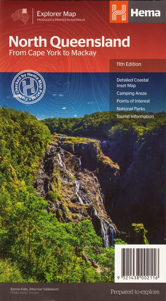
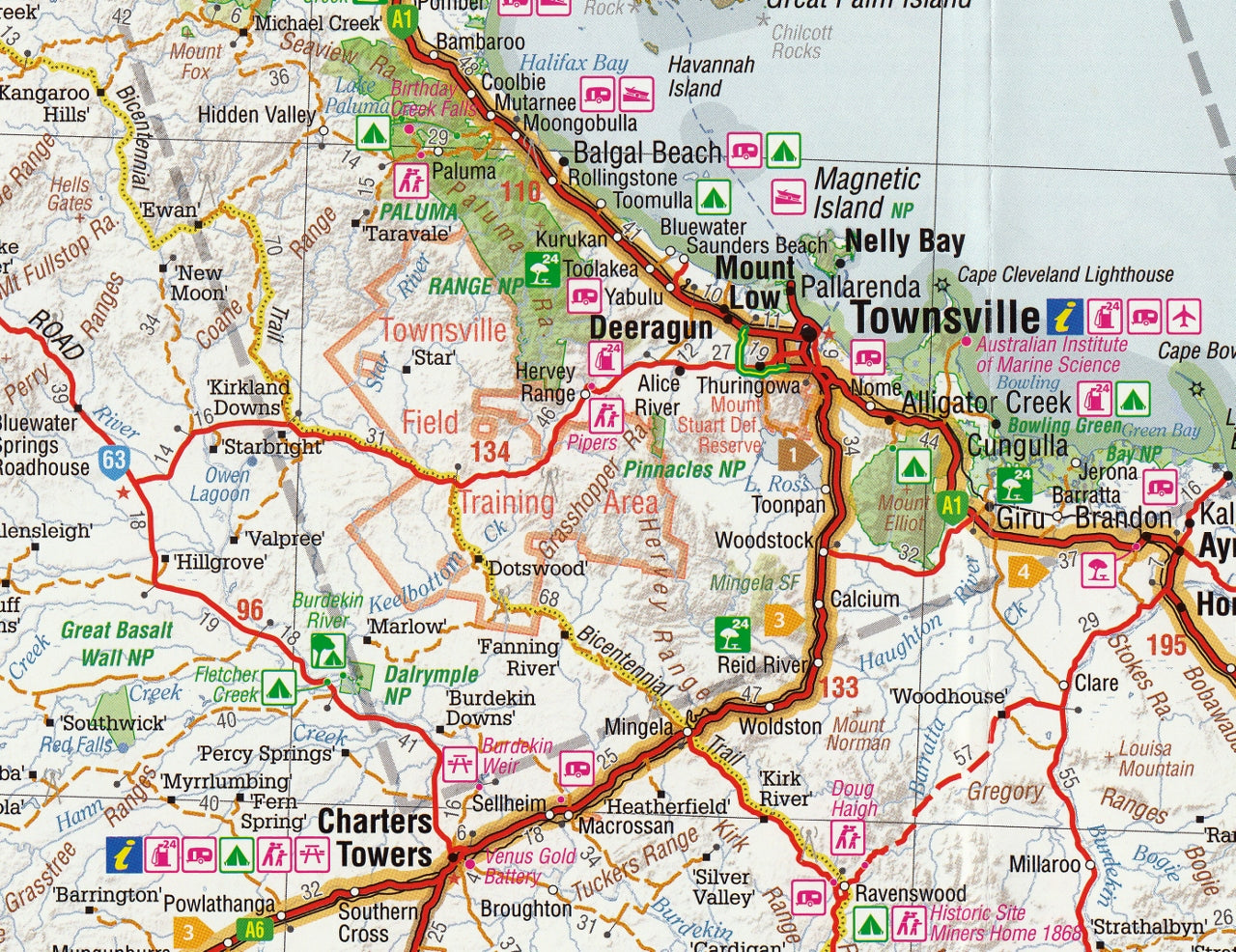
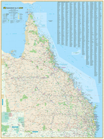
Hema North Queensland Regional Map – 11th Edition
$14.95
Afterpay is only available for orders between $50.00 and $1000.00 More info
Your essential companion for exploring tropical North Queensland from Mackay to the Tip of Cape York.
From the idyllic beaches of the Whitsundays to the rugged remoteness of Cape York, the Hema North Queensland Regional Map offers a detailed and reliable overview of one of Australia's most geographically diverse regions. Whether you're a tourist, four-wheel drive enthusiast, grey nomad, or weekend adventurer, this map provides the practical detail and visual clarity needed to navigate North Queensland with confidence.
Produced by Hema Maps—Australia's most trusted name in off-road and touring cartography—this 11th edition has been extensively field-checked and updated, making it perfect for both road travel and remote outback exploration.
🗺️ What the Map Covers
-
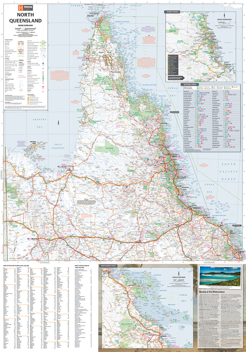
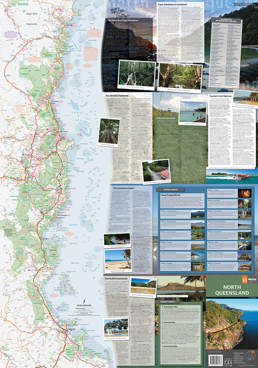
Geographic Scope:
-
Covers from Mackay in the south to the Tip of Cape York in the north
-
Includes the Whitsundays, Townsville, Ingham, Innisfail, Cairns, Cooktown, Weipa, Bamaga, and Torres Strait Islands
-
Extends westward to include remote inland roads, tracks, and national parks
-
-
Inset Maps:
-
Mackay & The Whitsundays
-
Townsville to Cooktown coastal strip
-
Selected town enlargements and island group highlights for added detail
-
🧭 Map Features
-
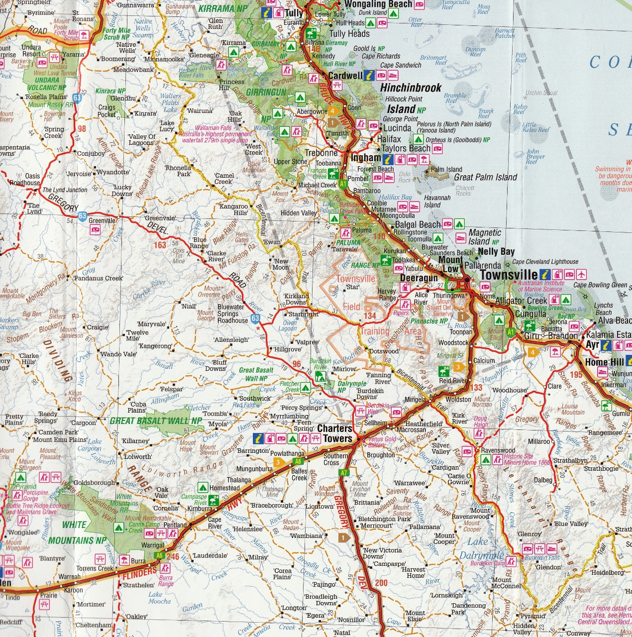
Scale: 1:750,000 — striking a balance between regional overview and navigational detail
-
Relief Shading & Topographic Detail: Helps you understand terrain, elevation, and access in both mountainous and coastal zones
-
4WD Tracks & Unsealed Roads: Clearly marked for overlanding and bush access, including distances and road classifications
-
National Parks & Conservation Areas: Clearly identified with boundaries and icons showing available facilities such as camping areas, walking trails, boat ramps, and lookouts
-
Touring Symbols: Pinpoint attractions like waterfalls, thermal springs, scenic lookouts, fishing spots, Aboriginal rock art sites, and more
-
Rest Stops & Fuel Locations: Strategically placed icons to assist in trip planning and vehicle range management
-
Distances & Driving Times: Between key towns and waypoints—handy for itinerary planning
📋 Technical Specifications
-
Edition: 11th Edition
-
Publication Date: December 2013
-
Flat Size: 1000 mm (W) x 700 mm (H)
-
Folded Size: 140 mm x 250 mm
-
Weight: Approx. 90g
-
Material: Printed on high-quality, durable paper with an easy-fold design
-
Optional Format: Laminated version available from select stockists
🏕️ Ideal For
-
4WD Explorers: Navigate inland tracks, national parks, and remote bush roads
-
Caravanners & Campers: Locate free campsites, caravan parks, and scenic overnight stops
-
Hikers & Nature Lovers: Discover national parks, walking trails, and natural wonders like waterfalls and gorges
-
Road Trippers: Plan multi-day drives from tropical coastlines to inland savannahs and rainforest routes
-
Tour Operators & Guides: Use as a visual aid when designing itineraries or guiding groups
-
Educational Use: Teachers and students studying North Queensland’s geography or tourism sector
🧭 Why Choose Hema?
Hema Maps is renowned for on-the-ground GPS fieldwork, which means the information you receive is not just desktop-compiled—it’s been driven, tested, and verified by professional mapmakers. You’re not just buying a map, you're accessing decades of travel experience and mapping expertise.
🧳 Summary
Whether you're winding your way up the Great Green Way, seeking adventure in the Cape York Peninsula, or relaxing on the coast near Port Douglas, the North Queensland Regional Map by Hema gives you the detail you need to explore this remarkable region safely and enjoyably.
Go prepared. Travel smart. Discover more.
With Hema, the road less travelled is never the road uncharted.
This map is also available as a laminated map encapsulated in high-quality plastic.
Frequently Asked Questions
Where can I buy the Hema North Queensland Regional Map – 11th Edition?
The Hema North Queensland Regional Map – 11th Edition is available to buy online from Mapworld, Australia's largest map and geographic product retailer, with fast shipping Australia-wide.
Is the Hema North Queensland Regional Map – 11th Edition in stock at Mapworld?
Mapworld maintains extensive stock across its map range and aims for fast dispatch. Orders placed before 2pm AEST on business days are typically dispatched the same day, with standard and express Australia-wide delivery options available.
What is Mapworld's returns policy?
Mapworld accepts returns on undamaged items in original condition. Contact Mapworld within 90 days of purchase to arrange a return or exchange.
Does Mapworld ship the Hema North Queensland Regional Map – 11th Edition across Australia?
Yes, Mapworld ships Australia-wide. Standard shipping is a flat $7 rate, with free standard shipping on orders over $75. Express options are available at checkout. Most orders placed before 2pm AEST on weekdays are dispatched same day.
Related Items

© 2026 Mapworld. Website designed by Genie Media
X