- Australia ▾
- Topographic
▾
- Australia AUSTopo 250k (2024)
- Australia 50k Geoscience maps
- Australia 100k Geoscience maps
- Australia 250k Geoscience maps
- Australia 1.1m Geoscience maps
- New Zealand 50k maps
- New Zealand 250k maps
- New South Wales 25k maps
- New South Wales 50k maps
- New South Wales 100k maps
- Queensland 10k maps
- Queensland 25k maps
- Queensland 50k maps
- Queensland 100k maps
- Compasses
- Software
- GPS Systems
- Orienteering
- International ▾
- Wall Maps
▾
- World
- Australia & New Zealand
- Countries, Continents & Regions
- Historical
- Vintage National Geographic
- Australian Capital Territory
- New South Wales
- Northern Territory
- Queensland
- South Australia
- Tasmania
- Victoria
- Western Australia
- Celestial
- Children's
- Mining & Resources
- Wine Maps
- Healthcare
- Postcode Maps
- Electoral Maps
- Nautical ▾
- Flags
▾
- Australian Flag Sets & Banners
- Flag Bunting
- Handwavers
- Australian National Flags
- Aboriginal Flags
- Torres Strait Islander Flags
- International Flags
- Flagpoles & Accessories
- Australian Capital Territory Flags
- New South Wales Flags
- Northern Territory Flags
- Queensland Flags
- South Australia Flags
- Tasmania Flags
- Victoria Flags
- Western Australia Flags
- Gifts ▾
- Globes ▾
Dear valued customer. Please note that our checkout is not supported by old browsers. Please use a recent browser to access all checkout capabilities


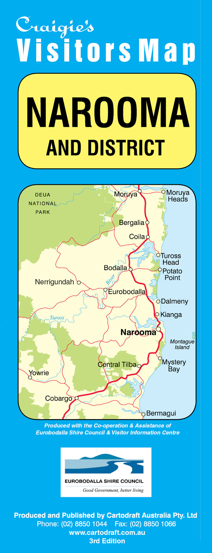
Narooma & District Craigies Map
$12.95
Afterpay is only available for orders between $50.00 and $1000.00 More info
Narooma & District Map – Craigies Premium Edition
Comprehensive Navigation for the Sapphire Coast and Eurobodalla Hinterland
Explore the breathtaking Sapphire Coast with the Narooma & District Map by Craigies, a meticulously crafted and highly accurate map designed for travellers, locals, and service professionals. Whether you're heading off on a weekend getaway, planning an extended road trip, or working in the region, this map provides you with the reliable information needed to navigate with ease and confidence.
This premium edition showcases the coastal and inland beauty of southern New South Wales, from the tranquil estuaries and wild headlands of Tuross Head, to the vibrant marina and rolling farmlands of Bermagui. Ideal for recreational use, tourism planning, deliveries, and local government reference, this map offers a wide scope of detail in a convenient format.
🌏 Regional Coverage
The district map stretches from:
-
Moruya in the north – gateway to Eurobodalla and the Clyde River
-
Bermagui in the south – known for deep-sea fishing and artisan food culture
-
And includes the full stretch of Eurobodalla’s coastal towns and villages in between
Explore the scenic and community-rich coastline and hinterland of:
-
🏖️ Narooma – the heart of the region, with access to Montague Island, golf courses, boardwalks, and whale-watching points
-
🏕️ Tuross Head – a peaceful estuary town ideal for kayaking, birdwatching, and fishing
-
🏡 Dalmeny & Kianga – relaxed seaside suburbs with local charm
-
🎣 Bermagui – a popular destination for fishing charters, coastal walks, and boutique shopping
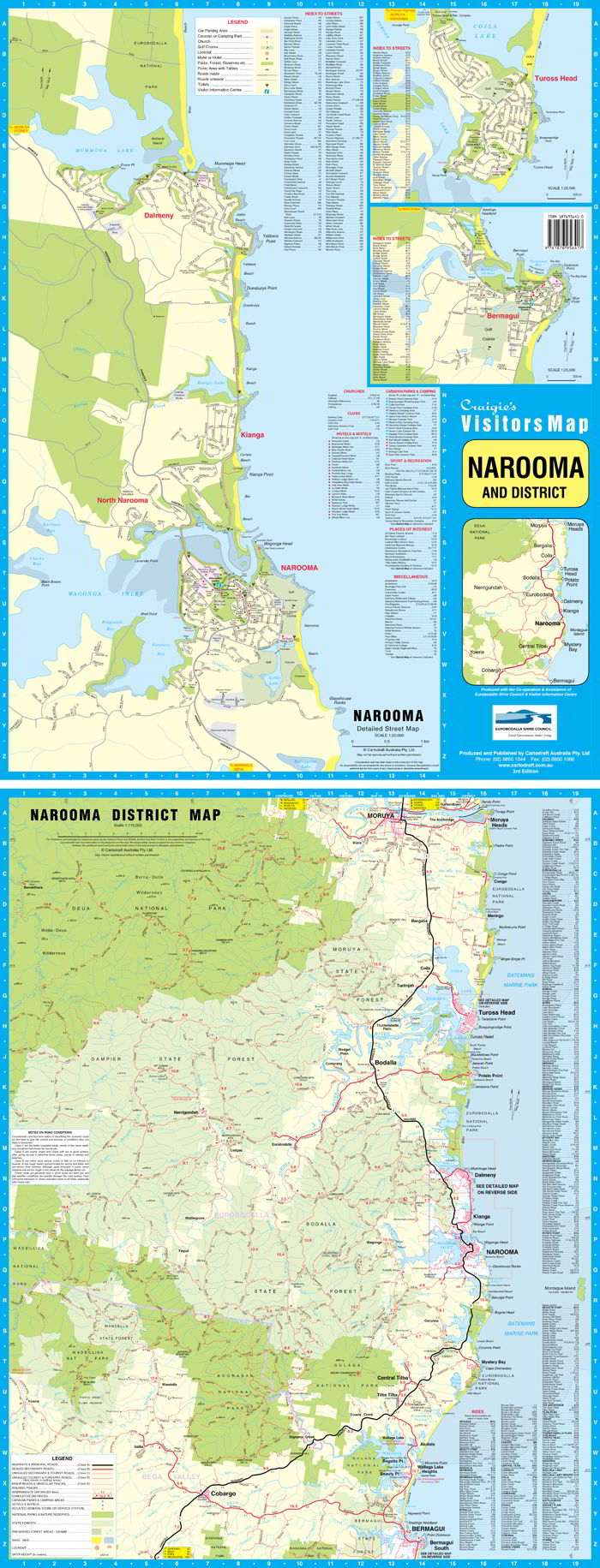
🏙️ Street Maps & Urban Detail
This edition includes high-resolution street maps for all key population centres, highlighting:
-
Street names and blocks
-
Community centres and local halls
-
Recreation grounds and sports facilities
-
Boat ramps, jetties, and wharfs
-
Medical centres, schools, churches, and amenities
✅ Featured Localities (with individual street-level maps):
-
Narooma
-
Bermagui
-
Tuross Head
-
Dalmeny
-
Kianga
These inset maps allow you to easily plan local walks, identify streets for deliveries or services, or locate the nearest beach access, fuel, or camping ground.
📐 Map Scales & Specifications
| Map Component | Scale | Coverage |
|---|---|---|
| District Map | 1:110,000 | Moruya to Bermagui, including inland routes |
| Street Maps (varies) | 1:20,000 – 1:25,000 | Narooma, Bermagui, Tuross Head, Dalmeny, Kianga |
-
Printed Format: Folded paper map for easy handling
-
Map Style: Full colour with clear iconography and legend
-
Size: Fits neatly in glove compartments, backpacks, or planning folders
🧭 Key Features
-
✔️ Up-to-date Road Network – Includes sealed roads, gravel roads, and scenic coastal drives
-
✔️ Tourist Symbols – Lookouts, picnic areas, visitor centres, accommodation options
-
✔️ Recreational Markers – Walking trails, beaches, surf breaks, cycle routes
-
✔️ Boating & Fishing Info – Boat ramps, river systems, marinas, estuaries
-
✔️ Cultural & Historical Points – Heritage towns, Aboriginal sites, lighthouses
-
✔️ Community Facilities – Emergency services, public toilets, schools, churches, fuel
-
✔️ Natural Features – Coastal cliffs, rivers, lakes, forests, wetlands
🌿 Perfect For:
-
Tourists & Holidaymakers – Navigate with ease between beaches, national parks, and charming towns
-
Caravanners & Campers – Plan stops, locate campgrounds, and find local amenities
-
Service Providers & Tradespeople – Pinpoint street-level locations for deliveries or call-outs
-
Outdoor Enthusiasts – Access bushwalking tracks, lookout points, and water access
-
Photographers & Nature Lovers – Discover hidden coves, forests, and estuarine landscapes
-
New Residents – Learn the layout of your community and surrounding region
-
Education & Research – A useful resource for geography projects, tourism studies, and regional development
🧭 Why Choose a Craigies Map?
Craigies Maps are Australian-made and designed with local knowledge and expert cartography. Renowned for clarity, durability, and ease of use, Craigies has served local governments, travellers, and community organisations for decades.
You can trust this map to provide:
-
Accurate geographic detail
-
Clear, legible fonts and symbology
-
Smart layout and regional logic
-
Reliable navigation and reference support
🧳 Plan with Confidence. Explore with Clarity.
Whether you're chasing a weekend escape, planning a coastal adventure, or servicing the Eurobodalla region for business, the Narooma & District Map by Craigies is your all-in-one tool for smart, seamless travel. Get to know the Sapphire Coast from the inside out — and never miss a highlight along the way.
Narooma awaits — let Craigies be your guide.


