- Australia ▾
- Topographic
▾
- Australia AUSTopo 250k (2024)
- Australia 50k Geoscience maps
- Australia 100k Geoscience maps
- Australia 250k Geoscience maps
- Australia 1.1m Geoscience maps
- New Zealand 50k maps
- New Zealand 250k maps
- New South Wales 25k maps
- New South Wales 50k maps
- New South Wales 100k maps
- Queensland 10k maps
- Queensland 25k maps
- Queensland 50k maps
- Queensland 100k maps
- Compasses
- Software
- GPS Systems
- Orienteering
- International ▾
- Wall Maps
▾
- World
- Australia & New Zealand
- Countries, Continents & Regions
- Historical
- Vintage National Geographic
- Australian Capital Territory
- New South Wales
- Northern Territory
- Queensland
- South Australia
- Tasmania
- Victoria
- Western Australia
- Celestial
- Children's
- Mining & Resources
- Wine Maps
- Healthcare
- Postcode Maps
- Electoral Maps
- Nautical ▾
- Flags
▾
- Australian Flag Sets & Banners
- Flag Bunting
- Handwavers
- Australian National Flags
- Aboriginal Flags
- Torres Strait Islander Flags
- International Flags
- Flagpoles & Accessories
- Australian Capital Territory Flags
- New South Wales Flags
- Northern Territory Flags
- Queensland Flags
- South Australia Flags
- Tasmania Flags
- Victoria Flags
- Western Australia Flags
- Gifts ▾
- Globes ▾
Dear valued customer. Please note that our checkout is not supported by old browsers. Please use a recent browser to access all checkout capabilities


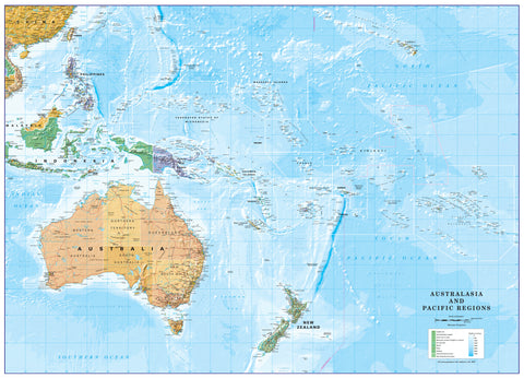
Micronesia Wall Map
$69.95
or make 4 interest-free payments of
$17.49 AUD
fortnightly with
![]() More info
More info
Geographic, Cultural & Environmental Overview
Size: 1000 mm (W) × 500 mm (H)
🌏 Explore the Heart of the Western Pacific
The Federated States of Micronesia (FSM) is a sovereign island nation and associated state of the United States, scattered across the vast expanse of the North Pacific Ocean. While its combined land area measures just 702 sq. km (271 sq. mi), its reach is immense — spanning a maritime territory of 2,600,000 sq. km, granting it the 14th largest Exclusive Economic Zone in the world.
This detailed wall map captures the intricate geography of FSM and its surrounding waters, providing both a visual reference and an educational resource.
🏝 Islands of the Caroline Archipelago
Comprising around 607 islands and islets, FSM is part of the Caroline Islands Archipelago. The nation’s geography is strikingly varied:
-
High Volcanic Islands – Rich, fertile soils, dense rainforests, and diverse flora.
-
Low-Lying Coral Atolls – Thin, sandy soils and unique coastal ecosystems.
🌿 Pohnpei – The Crown Jewel
The largest, wettest, and highest island in FSM, Pohnpei is a lush, mountainous sanctuary. Rising to Mount Nanlaud — the highest point in FSM at 782 m (2,566 ft) — the island’s rugged interior is cloaked in tropical rainforest, giving way to mangrove swamps on the lower slopes. A ring of coral reefs encircles the island, creating brilliant turquoise lagoons.
📍 Key Map Features
-
Detailed Geographic Coverage – Clearly shows the four FSM states: Yap, Chuuk, Pohnpei, and Kosrae.
-
Physical Relief & Elevations – Highlights mountainous terrain, volcanic origins, and atoll structures.
-
Marine & Coastal Details – Depicts surrounding seas, reef systems, and Exclusive Economic Zone boundaries.
-
Readable Labels – Towns, islands, and significant natural landmarks are clearly marked.
📐 Specifications
| Feature | Details |
|---|---|
| Dimensions | 1000 mm (W) × 500 mm (H) |
| Scale | Optimised for clarity and minimal distortion |
| Projection | Pacific-centred |
| Edition | Current |
| Origin | Made in Australia |
🖌 Premium Material & Display Options
| Format | Description |
|---|---|
| Paper (160 gsm) | Heavyweight matte-coated paper — perfect for framing under glass. |
| Laminated | Fully encapsulated in 80-micron gloss laminate — water-resistant, tear-proof, and compatible with non-permanent markers. |
| Laminated + Hang Rails | Laminated map mounted on natural timber rails with a hanging cord for ready-to-hang convenience. |
| Canvas (395 gsm) | HP Professional Matte Canvas printed with pigment-based inks for exceptional UV resistance, colour depth, and a tactile finish. |
| Canvas + Hang Rails | Canvas version mounted on lacquered timber rails for a stylish, gallery-quality display. |
Please Note: Allow up to 10 working days for delivery of hang-railed maps, as they are professionally mounted by our framer.
🎯 Who Is This Map For?
-
Educators & Students – Perfect for geography, environmental science, and marine studies.
-
Travellers & Sailors – Ideal for voyage planning across the Pacific.
-
Environmental Organisations – Useful for marine conservation and climate research.
-
Collectors & Decorators – A striking conversation piece for home or office.
🌟 Why This Micronesia Map is Special
-
Combines Political & Physical Detail – Suitable for reference, research, or display.
-
Rich Geographic Context – Highlights both land and marine territories.
-
Durable Formats – From archival-grade paper to museum-quality canvas.
-
Australian Made – Printed locally using pigment-based inks for lasting colour and detail.