- Australia ▾
- Topographic
▾
- Australia AUSTopo 250k (2025)
- Australia 50k Geoscience maps
- Australia 100k Geoscience maps
- Australia 250k Geoscience maps
- Australia 1:1m Geoscience maps
- New Zealand 50k maps
- New Zealand 250k maps
- New South Wales 25k maps
- New South Wales 50k maps
- New South Wales 100k maps
- Queensland 10k maps
- Queensland 25k maps
- Queensland 50k maps
- Queensland 100k maps
- Western Australia 25k maps
- Western Australia 50k maps
- Western Australia 100k maps
- Compasses
- Software
- GPS Systems
- International ▾
- Wall Maps
▾
- World
- Australia & New Zealand
- Countries, Continents & Regions
- Historical
- Vintage National Geographic
- Australian Capital Territory
- New South Wales
- Northern Territory
- Queensland
- South Australia
- Tasmania
- Victoria
- Western Australia
- Celestial
- Children's
- Mining & Resources
- Wine Maps
- Healthcare
- Postcode Maps
- Electoral Maps
- Nautical ▾
- Flags
▾
- Australian Flag Sets & Banners
- Flag Bunting
- Handwavers
- Australian National Flags
- Aboriginal Flags
- Torres Strait Islander Flags
- International Flags
- Flagpoles & Accessories
- Australian Capital Territory Flags
- New South Wales Flags
- Northern Territory Flags
- Queensland Flags
- South Australia Flags
- Tasmania Flags
- Victoria Flags
- Western Australia Flags
- Gifts ▾
- Globes ▾
Dear valued customer. Please note that our checkout is not supported by old browsers. Please use a recent browser to access all checkout capabilities


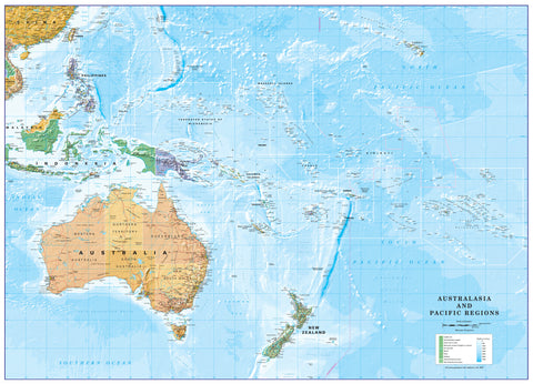
Melanesia Wall Map
$69.95
or make 4 interest-free payments of
$17.49 AUD
fortnightly with
![]() More info
More info
Geographic, Cultural & Anthropological Overview
Size: 1000 mm (W) × 900 mm (H)
🌏 Discover the Islands of Melanesia
Stretching across the southwestern Pacific, Melanesia is a captivating region of volcanic high islands, lush tropical rainforests, and extraordinary cultural diversity. This detailed wall map captures the geographic beauty and complexity of an area that includes:
-
Papua New Guinea
-
Solomon Islands
-
Vanuatu
-
New Caledonia
-
Fiji (in the east, with cultural influences from both Melanesia and Polynesia)
From the jagged peaks of Papua New Guinea’s Highlands to the coral-fringed shores of Vanuatu, Melanesia is a place where nature’s power and human heritage intertwine.
🏝 A Cultural and Linguistic Tapestry
The Melanesian peoples are renowned for their rich traditions, deep ties to the land, and intensely tribal societies. This is one of the most linguistically diverse regions on Earth, with over 1,300 languages spoken.
While Fiji and New Caledonia have their own distinct histories and official languages, most of Melanesia is united by a modern form of pidgin English — a simplified, adaptable language blending English with local vocabulary.
Physically, Melanesian people are often described as shorter and sturdier than their Polynesian neighbours, with tightly curled hair, dark complexions, and ancestral links to both Papuan and Austronesian peoples.
📍 Key Map Features
-
Comprehensive Geographic Coverage – Clearly shows the islands, seas, and neighbouring regions.
-
Physical Landforms – Highlights mountainous interiors, volcanic origins, and coastal plains.
-
Political Boundaries – Clear demarcation of nations and territories.
-
Surrounding Waters – Includes the Coral Sea, Solomon Sea, and other key maritime regions.
-
Readable Labels – Towns, capitals, and major geographic features marked with clarity.
📐 Specifications
| Feature | Details |
|---|---|
| Dimensions | 1000 mm (W) × 900 mm (H) |
| Projection | Designed for clarity and minimal distortion |
| Orientation | Landscape |
| Edition | Current |
| Origin | Made in Australia |
🖌 Premium Material & Display Options
| Format | Description |
|---|---|
| Paper (160 gsm) | Heavyweight matte-coated paper — perfect for framing under glass. |
| Laminated | Fully encapsulated in 80-micron gloss laminate — water-resistant, tear-proof, and compatible with non-permanent markers. |
| Laminated + Hang Rails | Laminated map mounted on natural timber rails with a hanging cord for ready-to-hang convenience. |
| Canvas (395 gsm) | HP Professional Matte Canvas printed with pigment-based inks for exceptional UV resistance, colour depth, and a tactile finish. |
| Canvas + Hang Rails | Canvas version mounted on lacquered timber rails for a stylish, gallery-quality display. |
Please Note: Allow up to 10 working days for delivery of hang-railed maps, as they are professionally mounted by our framer.
🎯 Who Is This Map For?
-
Geography Enthusiasts – Explore one of the most culturally and linguistically diverse regions on Earth.
-
Educators & Students – Ideal for history, anthropology, and geography classrooms.
-
Travellers & Sailors – Plan voyages and explore the maritime geography of Melanesia.
-
Collectors & Decorators – A conversation piece for studies, offices, and libraries.
🌟 Why This Melanesia Map is Special
-
Combines Physical & Political Detail – Perfect for both reference and display.
-
Rich Cultural Context – Brings geography to life with anthropological insight.
-
Durable Formats – From archival paper to museum-grade canvas.
-
Australian Made – Printed locally with fade-resistant pigment inks for longevity.
Frequently Asked Questions
What are the dimensions of the Melanesia Wall Map?
Mapworld wall maps range from standard 700×1000mm to large-format 1000×1430mm Supermaps. The exact dimensions for this map are shown in the product title. Where multiple sizes are available, select your preferred size when adding to cart.
Is this wall map available laminated?
Many Mapworld wall maps are available in paper, laminated, or framed finishes. Check the product options when adding to cart. Laminated maps are wipe-clean and more durable.
Is this the latest edition?
Mapworld stocks the most current editions available from all publishers. Edition year is shown in the product title where applicable. Mapworld updates its catalogue as new editions are released.
Can I write on or pin this wall map?
Laminated wall maps can be written on with whiteboard markers and wiped clean. Paper maps can be pinned on a corkboard. Choose a laminated option for a writeable surface.
Does Mapworld ship the Melanesia Wall Map across Australia?
Yes, Mapworld ships Australia-wide. Standard shipping is a flat $7 rate, with free standard shipping on orders over $75. Express options are available at checkout. Most orders placed before 2pm AEST on weekdays are dispatched same day.
Related Items


© 2026 Mapworld. Website designed by Genie Media
X