- Australia ▾
- Topographic
▾
- Australia AUSTopo 250k (2025)
- Australia 50k Geoscience maps
- Australia 100k Geoscience maps
- Australia 250k Geoscience maps
- Australia 1:1m Geoscience maps
- New Zealand 50k maps
- New Zealand 250k maps
- New South Wales 25k maps
- New South Wales 50k maps
- New South Wales 100k maps
- Queensland 10k maps
- Queensland 25k maps
- Queensland 50k maps
- Queensland 100k maps
- Western Australia 25k maps
- Western Australia 50k maps
- Western Australia 100k maps
- Compasses
- Software
- GPS Systems
- International ▾
- Wall Maps
▾
- World
- Australia & New Zealand
- Countries, Continents & Regions
- Historical
- Vintage National Geographic
- Australian Capital Territory
- New South Wales
- Northern Territory
- Queensland
- South Australia
- Tasmania
- Victoria
- Western Australia
- Celestial
- Children's
- Mining & Resources
- Wine Maps
- Healthcare
- Postcode Maps
- Electoral Maps
- Nautical ▾
- Flags
▾
- Australian Flag Sets & Banners
- Flag Bunting
- Handwavers
- Australian National Flags
- Aboriginal Flags
- Torres Strait Islander Flags
- International Flags
- Flagpoles & Accessories
- Australian Capital Territory Flags
- New South Wales Flags
- Northern Territory Flags
- Queensland Flags
- South Australia Flags
- Tasmania Flags
- Victoria Flags
- Western Australia Flags
- Gifts ▾
- Globes ▾
Dear valued customer. Please note that our checkout is not supported by old browsers. Please use a recent browser to access all checkout capabilities


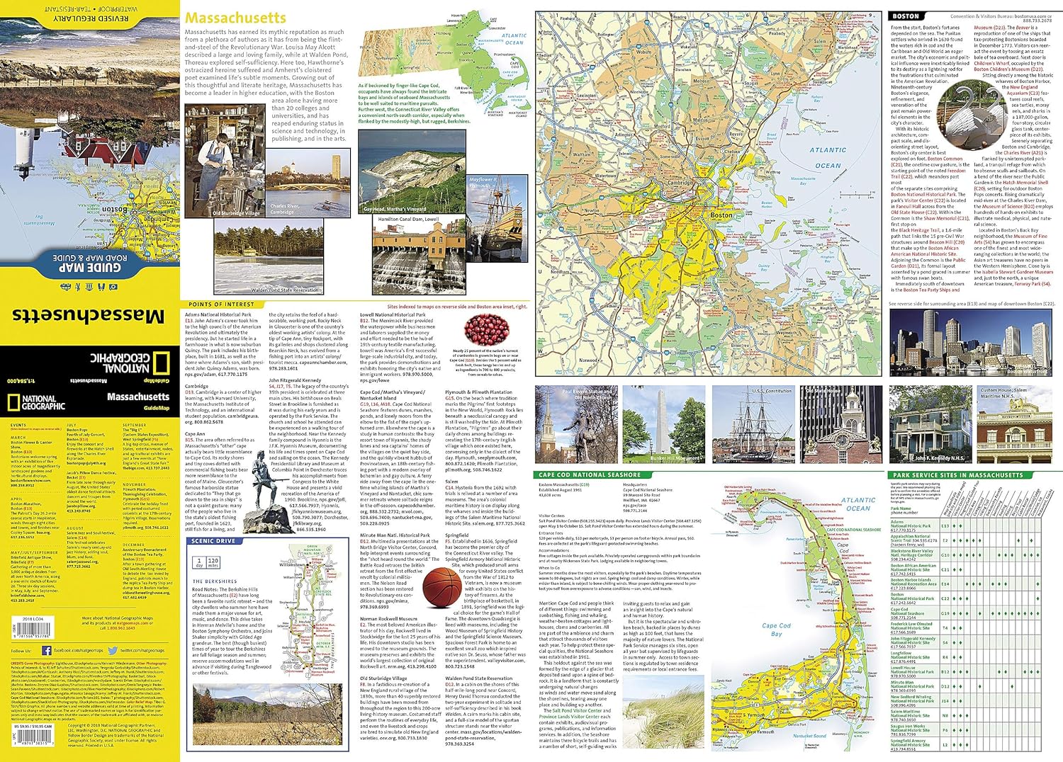
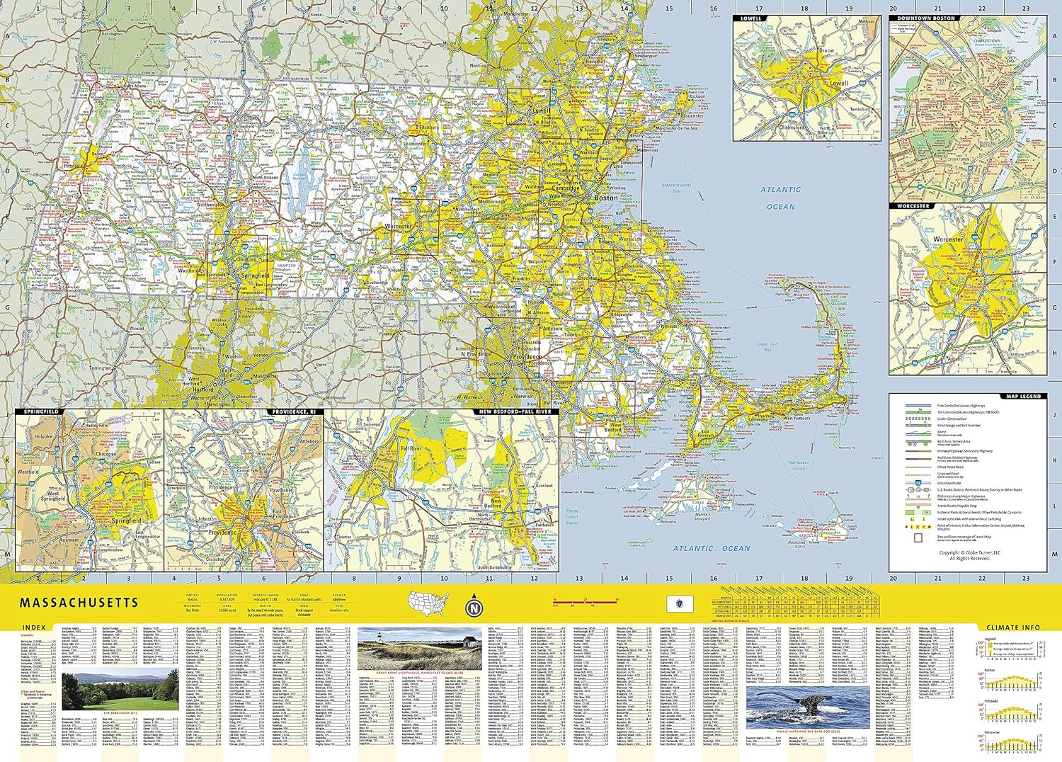
Massachusetts National Geographic Folded Map
$29.95
Afterpay is only available for orders between $50.00 and $1000.00 More info
🦞 Massachusetts – National Geographic State Guide Map
Waterproof • Tear-Resistant • Travel Map
From the cobblestone streets of Boston to the windswept dunes of Cape Cod, National Geographic’s Massachusetts State Guide Map blends meticulous cartography with practical travel information, making it an indispensable resource for exploring the Bay State. Whether you’re tracing the Freedom Trail, skiing in the Berkshires, or heading for a summer escape on Martha’s Vineyard, this map delivers clarity, durability, and detail.
🗺 Comprehensive Statewide Coverage
-
Road Network – All interstate, state, and county routes clearly marked, with mileage indicators for major highways
-
Access Types – Freeways, toll roads, paved and unpaved routes, and scenic byways clearly distinguished
-
Travel Essentials – Rest areas, airports, hospitals, public recreation areas, ski areas, and visitor information centers
📍 Detailed Insets for Key Destinations
-
Boston Metropolitan Area – Navigate the capital with ease
-
Downtown Boston – A closer look at historic streets, landmarks, and districts
-
Lowell – Once the heart of the American Industrial Revolution
-
Worcester – Central Massachusetts’ cultural and economic hub
🌊 Bonus Travel Guides & Features
-
Cape Cod National Seashore – Includes a dedicated map, visitor contact details, and key sites along the Atlantic shore
-
National Parks & Sites Chart – Service availability at major recreation areas
-
Calendar of Events – Highlighting annual festivals, parades, and cultural happenings
-
Points of Interest Guide – Contact information for Massachusetts’ most popular attractions, from historic sites to outdoor adventures
📐 Product Specifications
| Feature | Detail |
|---|---|
| Publisher | National Geographic Maps |
| Map Type | Folded State Guide Map |
| Material | Waterproof, tear-resistant synthetic paper |
| Scale | Statewide with multiple insets |
| Format | Double-sided |
| Flat Size | 660 mm x 940 mm (26" x 37") |
| Folded Size | 102 mm x 229 mm (4" x 9") |
| Order Info | Order on Demand – Please allow 7–10 working days for delivery |
🎯 Perfect For
-
City explorers navigating Boston and historic towns
-
Outdoor enthusiasts planning coastal hikes, cycling routes, or skiing trips
-
Cultural travellers following the state’s museums, theatres, and festivals
-
Educational trips to Revolutionary War sites and historic districts
With National Geographic’s Massachusetts State Guide Map, you’ll have a trusted, weatherproof, and detail-rich companion to guide you from colonial harbours to mountain trails—all in one beautifully designed, travel-ready format.
Frequently Asked Questions
What area does the Massachusetts National Geographic Folded Map cover?
The Massachusetts National Geographic Folded Map provides road coverage of the region named in the product title. The map covers major cities, highways, towns, and regional roads, with inset city maps for key urban centres where applicable.
Is the Massachusetts National Geographic Folded Map up to date?
Yes, this is the current edition. Mapworld stocks the most current editions from all major publishers, updated to reflect new roads and infrastructure.
What size is this map when unfolded?
Folded maps from Mapworld's range are compact and portable. Most standard folded road or travel maps open to between A1 (594 × 841mm) and A0 (841 × 1189mm) when fully unfolded, and fold down to approximately A4 or smaller for easy storage in a glove box, bag, or backpack.
Is the Massachusetts National Geographic Folded Map in stock at Mapworld?
Mapworld maintains extensive stock across its map range and aims for fast dispatch. Orders placed before 2pm AEST on business days are typically dispatched the same day, with standard and express Australia-wide delivery options available.
Does Mapworld ship the Massachusetts National Geographic Folded Map across Australia?
Yes, Mapworld ships Australia-wide. Standard shipping is a flat $7 rate, with free standard shipping on orders over $75. Express options are available at checkout. Most orders placed before 2pm AEST on weekdays are dispatched same day.
Related Items


© 2026 Mapworld. Website designed by Genie Media
X