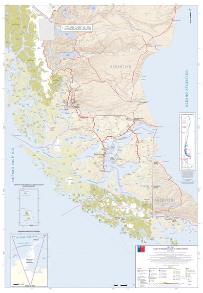
Magallanes Region Wall Map — Chile (Magallanes y Antártica Chilena)
Patagonia & Chilean Fjords | Torres del Paine | Tierra del Fuego | Premium Finishes
Chart the far south of the world with a beautifully detailed wall map of Chile’s Magallanes Region—from the wind-scoured steppe of Patagonia and the granite spires of Torres del Paine, to labyrinthine fjords, tidewater glaciers, and the remote islands of Tierra del Fuego. Anchor points such as Punta Arenas on the Strait of Magellan, Puerto Natales, and Cabo de Hornos (Cape Horn) set the scene for epic sea passages and once-in-a-lifetime overland journeys.
🗺️ Why this map captivates
-
Iconic landscapes — Torres del Paine massif, Southern Patagonian Icefield, fjords, channels, and open steppe rendered with clear relief shading.
-
Gateway to Antarctica — Context for expedition routes, Antarctic logistics hubs, and southern island chains.
-
Wildlife & wild seas — A region known for penguins, guanacos, condors, sea lions, and fiercely beautiful weather.
-
Travel-ready overview — Locate towns, ferry corridors, border crossings, national parks, estancias, and key approach roads.
-
Cruise companion — An excellent wall reference for voyages through the Strait of Magellan, Beagle Channel, and beyond.
(Wall-map overview; always use current navigation charts, park notices, and operator guidance when travelling.)
🔎 What you’ll see on the map
-
Relief & hydrology for quick reading of mountains, icefields, channels, and lakes.
-
Regional structure — provinces, protected areas, and key locality labels optimised for wall readability.
-
Access & orientation — principal highways, ferry links, and approach routes to major sights and trailheads.
-
Clean, cartographic palette — designed to look refined at home, office, lodge, or classroom scale.
✨ Premium finishes (choose your display)
| Format | Description |
|---|---|
| 📜 Paper (160 gsm matte) | Archival, smooth finish—ideal for framing under glass. |
| 🧼 Laminated (True Encapsulation) | 2 × 80-micron gloss, edge-sealed—durable, wipe-clean, planning-friendly. |
| 🖼️ Canvas (395 gsm HP Professional Matte) | Gallery-grade texture; printed with pigment-based, fade-resistant inks. |
| 🪵 Laminated + Timber Hang Rails | Natural timber rails (top/bottom) with fitted cord—ready to hang. Allow up to 10 working days. |
| 🪵 Canvas + Timber Hang Rails | Canvas finished with lacquered natural timber rails—frameless elegance. Allow up to 10 working days. |
📐 Specifications
| Feature | Detail |
|---|---|
| Title | Magallanes Region Wall Map — Chile (Magallanes y Antártica Chilena) |
| Coverage | Patagonia (Chile), Torres del Paine, Tierra del Fuego, Strait of Magellan & southern channels |
| Dimensions | 1000 mm (W) × 700 mm (H) |
| Map Type | Physical / Political regional overview |
| Finishes | Paper, Laminated (2 × 80-micron), Canvas (395 gsm), optional timber hang rails |
| Printing | Archival pigment inks for long-term colour stability |
| Origin | Printed in Australia |
🎯 Who it’s for
-
Travellers & cruise passengers exploring Patagonia’s fjords and channels.
-
Guides, lodges & classrooms needing a clear regional reference.
-
Design-led interiors seeking an adventurous, conversation-starting centrepiece.
-
Wildlife & photo enthusiasts mapping colonies, steppe routes, and lookout points.
🤝 Our Commitment
-
Local craftsmanship: Designed, printed, and finished in Australia.
-
Premium materials: Archival HP pigment inks, professional laminates, natural timber rails.
-
Colour-managed clarity: Wall-readable labels and consistent cartography at statement scale.
-
Built to last: Durable finishes to extend service life and reduce waste.
-
Packed with care: Every map is hand-checked and shipped to arrive clean and display-ready.
🚚 Shipping & lead time
-
Paper / Laminated / Canvas (rolled): Usually ships within 1–2 business days.
-
Hang-railed maps: Custom mounted—please allow up to 10 working days.
Bring the world’s far south to your wall—a daily invitation to the winds, wildlife, and wonder of Magallanes. Add to cart and start planning your Patagonian adventure.


