- Australia ▾
- Topographic
▾
- Australia AUSTopo 250k (2024)
- Australia 50k Geoscience maps
- Australia 100k Geoscience maps
- Australia 250k Geoscience maps
- Australia 1.1m Geoscience maps
- New Zealand 50k maps
- New Zealand 250k maps
- New South Wales 25k maps
- New South Wales 50k maps
- New South Wales 100k maps
- Queensland 10k maps
- Queensland 25k maps
- Queensland 50k maps
- Queensland 100k maps
- Compasses
- Software
- GPS Systems
- Orienteering
- International ▾
- Wall Maps
▾
- World
- Australia & New Zealand
- Countries, Continents & Regions
- Historical
- Vintage National Geographic
- Australian Capital Territory
- New South Wales
- Northern Territory
- Queensland
- South Australia
- Tasmania
- Victoria
- Western Australia
- Celestial
- Children's
- Mining & Resources
- Wine Maps
- Healthcare
- Postcode Maps
- Electoral Maps
- Nautical ▾
- Flags
▾
- Australian Flag Sets & Banners
- Flag Bunting
- Handwavers
- Australian National Flags
- Aboriginal Flags
- Torres Strait Islander Flags
- International Flags
- Flagpoles & Accessories
- Australian Capital Territory Flags
- New South Wales Flags
- Northern Territory Flags
- Queensland Flags
- South Australia Flags
- Tasmania Flags
- Victoria Flags
- Western Australia Flags
- Gifts ▾
- Globes ▾
Dear valued customer. Please note that our checkout is not supported by old browsers. Please use a recent browser to access all checkout capabilities
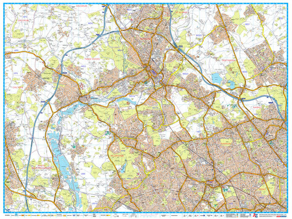
London Master Plan North West A-Z 1015 x 763mm Wall Map
$69.95
or make 4 interest-free payments of
$17.49 AUD
fortnightly with
![]() More info
More info
Size: 1015 mm (W) x 763 mm (H)
Scale: 1:21,477
Published: 2019
Publisher: Geographers’ A-Z Map Company
🧭 Navigate the Urban Heart of North West London
From the leafy avenues of Hampstead to the bustling energy of Wembley and Harrow, explore North West London in fine detail with this Master Plan Wall Map by the Geographers’ A-Z Map Company — Britain’s most trusted name in urban cartography.
This highly detailed wall map is part of a 9-sheet Master Plan series that together form a complete overview of Greater London. Designed for professionals, educators, businesses, and anyone needing an accurate reference, it features postcode district boundaries, local authority areas, and full street-level mapping — all rendered in A-Z’s iconic and easy-to-read style.
🔍 Map Features
| ✅ | Key Details |
|---|---|
| 🗺️ | Complete street-level detail with A-Z's classic style |
| 📮 | Clearly marked postcode districts and sector outlines |
| 🏙️ | Highlights local authority boundaries |
| 🚉 | Shows Underground, Overground, rail lines, and stations |
| 🏞️ | Depicts green spaces, rivers, parks, and major civic features |
| 🧩 | Designed to join seamlessly with other Master Plan sheets |
📍 Coverage Includes:
-
Hampstead
-
Wembley
-
Kilburn
-
Harrow
-
Willesden
-
Neasden
-
Cricklewood
-
Queens Park
-
Golders Green
-
Brent Cross
Whether you're planning deliveries, managing city infrastructure, or simply want a clear reference of the region, this map brings precision and clarity to every corner of North West London.
📐 Specifications
| Attribute | Detail |
|---|---|
| Scale | 1:21,477 |
| Dimensions | 1015 mm (wide) x 763 mm (high) |
| Publisher | Geographers’ A-Z Map Company |
| Edition | 2019 |
| Map Series | 1 of 9 Master Plan maps of London |
| Data Source | Ordnance Survey + A-Z street mapping |
🖨️ Format Options
| 📄 Format | 📋 Description |
|---|---|
| Paper (160 gsm) | Premium quality paper — ideal for pinning, mounting, or framing |
| Laminated | Fully encapsulated in 80-micron gloss laminate — durable, waterproof, and wipeable |
| Laminated with Hang Rails | Ready-to-hang with natural timber hang rails and cord |
| Canvas (395 gsm) | Printed on museum-grade HP Matte Canvas — fade-resistant and rich in texture |
| Canvas with Hang Rails | Mounted with timber rails for a timeless gallery-ready finish |
🎯 Ideal For:
-
🏢 Offices and council buildings needing postcode and borough reference
-
🚚 Delivery and logistics teams planning routes across North West London
-
🏫 Geography teachers and students studying London’s urban form
-
🗂️ Property professionals and urban planners tracking boundaries and growth
-
🖼️ Designers and stylists seeking a visually striking urban map for décor
Master your knowledge of North West London with the A-Z wall map that professionals trust.
Build your complete Greater London wall display or enjoy this map on its own as a bold, functional centrepiece.


