- Australia ▾
- Topographic
▾
- Australia AUSTopo 250k (2024)
- Australia 50k Geoscience maps
- Australia 100k Geoscience maps
- Australia 250k Geoscience maps
- Australia 1.1m Geoscience maps
- New Zealand 50k maps
- New Zealand 250k maps
- New South Wales 25k maps
- New South Wales 50k maps
- New South Wales 100k maps
- Queensland 10k maps
- Queensland 25k maps
- Queensland 50k maps
- Queensland 100k maps
- Compasses
- Software
- GPS Systems
- Orienteering
- International ▾
- Wall Maps
▾
- World
- Australia & New Zealand
- Countries, Continents & Regions
- Historical
- Vintage National Geographic
- Australian Capital Territory
- New South Wales
- Northern Territory
- Queensland
- South Australia
- Tasmania
- Victoria
- Western Australia
- Celestial
- Children's
- Mining & Resources
- Wine Maps
- Healthcare
- Postcode Maps
- Electoral Maps
- Nautical ▾
- Flags
▾
- Australian Flag Sets & Banners
- Flag Bunting
- Handwavers
- Australian National Flags
- Aboriginal Flags
- Torres Strait Islander Flags
- International Flags
- Flagpoles & Accessories
- Australian Capital Territory Flags
- New South Wales Flags
- Northern Territory Flags
- Queensland Flags
- South Australia Flags
- Tasmania Flags
- Victoria Flags
- Western Australia Flags
- Gifts ▾
- Globes ▾
Dear valued customer. Please note that our checkout is not supported by old browsers. Please use a recent browser to access all checkout capabilities


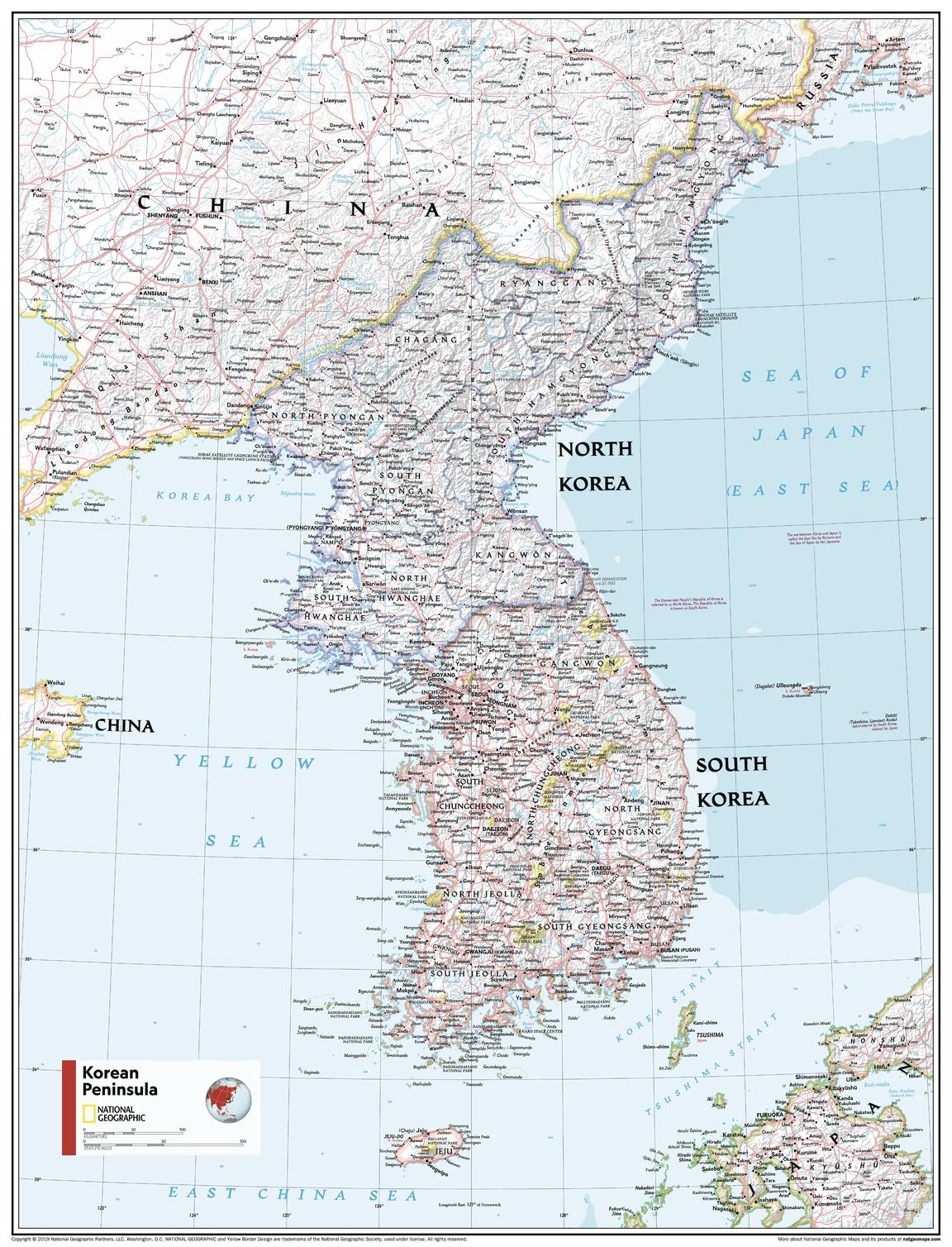
Korean Peninsula Atlas of the World, 11th Edition, National Geographic Wall Map
$69.95
or make 4 interest-free payments of
$17.49 AUD
fortnightly with
![]() More info
More info
🇰🇷 Korean Peninsula Wall Map
National Geographic | Atlas of the World, 11th Edition
A compelling cartographic portrait of a region shaped by history, culture, and natural beauty.
From the towering peaks of the Taebaek Mountains to the bustling metropolises of Seoul and Pyongyang, the Korean Peninsula Wall Map by National Geographic presents this dynamic and geopolitically important region with incredible clarity, geographical precision, and stunning visual appeal.
Originally featured in the 11th Edition of the National Geographic Atlas of the World, this map seamlessly combines physical terrain and political boundaries in a format that’s both elegant and highly informative—ideal for educators, travellers, and global studies enthusiasts.
🌏 Key Map Features
| Feature | Details |
|---|---|
| 🗺️ Map Type | Physical & Political – includes topography, cities, rivers, and coastlines |
| 🧭 Projection | Polyconic – curved parallels with straight equator, ideal for regional accuracy |
| 🏞️ Shaded Relief | Features mountain ranges, rivers, coastline and ocean bathymetry |
| 📌 Insets | Includes Central Japan & Ryukyu Islands |
| 🧾 Reference Panels | Lists administrative divisions of North and South Korea |
| 🎨 Design Palette | Bright, accessible colours with soft shaded relief and blue oceans |
🖼️ Available Formats
Choose a finish to suit your space, whether you're creating an inspiring classroom, stylish study, or elegant library wall:
| Format | Details |
|---|---|
| 📄 Paper | 160 gsm premium matte – ideal for framing under glass |
| 💧 Laminated | Encapsulated in 80-micron gloss laminate – tear-resistant and writable |
| 🪵 Laminated + Hang Rails | Fitted with timber hang rails and cord – ready to hang |
| 🖼️ Canvas | Printed on 395 gsm HP Matte Canvas – durable, fade-resistant archival inks |
| 🪵 Canvas + Hang Rails | Finished with natural timber hang rails – premium display option |
⏳ Please allow up to 10 working days for delivery of hang-railed maps, as these are handcrafted by our framer.
📐 Specifications
| Attribute | Details |
|---|---|
| Title | Korean Peninsula – Atlas of the World Map |
| Publisher | National Geographic |
| Edition | 11th Edition |
| Style | Physical & Political |
| Projection | Polyconic |
| Standard Size | 790 mm (H) × 610 mm (W) |
| Supermap Size | 1197 mm (H) × 915 mm (W) |
| Published | 2019 |
| Origin | Made in Australia |
🎓 Perfect For:
-
🏫 Classrooms – Ideal for teaching geography, East Asian history, or international relations
-
🏢 Workspaces – Add cultural and geopolitical context to your office or study
-
🧳 Globetrotters & Scholars – Trace your travels or explore the region’s complexity
-
🎁 Gift Buyers – A thoughtful present for educators, travellers, or map collectors
With its refined cartography, rich contextual detail, and flexible display options, the Korean Peninsula Wall Map is a visually stunning and intellectually enriching piece for any space.


