- Australia ▾
- Topographic
▾
- Australia AUSTopo 250k (2024)
- Australia 50k Geoscience maps
- Australia 100k Geoscience maps
- Australia 250k Geoscience maps
- Australia 1.1m Geoscience maps
- New Zealand 50k maps
- New Zealand 250k maps
- New South Wales 25k maps
- New South Wales 50k maps
- New South Wales 100k maps
- Queensland 10k maps
- Queensland 25k maps
- Queensland 50k maps
- Queensland 100k maps
- Compasses
- Software
- GPS Systems
- Orienteering
- International ▾
- Wall Maps
▾
- World
- Australia & New Zealand
- Countries, Continents & Regions
- Historical
- Vintage National Geographic
- Australian Capital Territory
- New South Wales
- Northern Territory
- Queensland
- South Australia
- Tasmania
- Victoria
- Western Australia
- Celestial
- Children's
- Mining & Resources
- Wine Maps
- Healthcare
- Postcode Maps
- Electoral Maps
- Nautical ▾
- Flags
▾
- Australian Flag Sets & Banners
- Flag Bunting
- Handwavers
- Australian National Flags
- Aboriginal Flags
- Torres Strait Islander Flags
- International Flags
- Flagpoles & Accessories
- Australian Capital Territory Flags
- New South Wales Flags
- Northern Territory Flags
- Queensland Flags
- South Australia Flags
- Tasmania Flags
- Victoria Flags
- Western Australia Flags
- Gifts ▾
- Globes ▾
Dear valued customer. Please note that our checkout is not supported by old browsers. Please use a recent browser to access all checkout capabilities
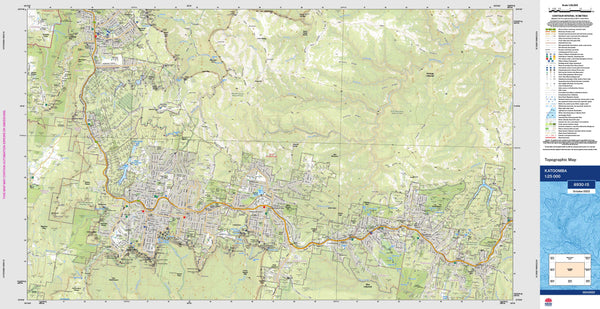
Katoomba 8930-1S Topographic Map 1:25k
$19.95
Afterpay is only available for orders between $50.00 and $1000.00 More info
An essential tool for navigation, planning, and exploration in the heart of the Blue Mountains.
The Katoomba Topographic Map by NSW Land and Property Information (LPI) is part of the authoritative 1:25,000 topographic mapping series, offering incredibly fine detail ideal for both professional use and outdoor recreation. Centred on the historic township of Katoomba, this map covers the spectacular escarpments, valleys, and bushland of the Blue Mountains National Park, one of Australia's most iconic and rugged landscapes.
Whether you're bushwalking along the Narrow Neck Plateau, exploring the vast network of trails and fire trails, or conducting environmental and planning work, this map delivers the precision and clarity required to safely and effectively navigate one of New South Wales’ most topographically complex regions.
🗺️ Map Content and Features
At 1:25,000 scale, this map is highly detailed—1 centimetre on the map represents 250 metres on the ground. It includes:
-
Contour lines showing elevation at fine intervals, allowing for accurate terrain analysis
-
Watercourses – creeks, rivers, and drainage systems clearly marked
-
Walking tracks, roads, fire trails, and 4WD routes, ideal for planning travel or emergency access
-
Buildings and infrastructure – from isolated shelters to public facilities
-
Vegetation mapping – forests, scrubland, open areas, and more
-
Place names and geographic features – peaks, gorges, cliffs, and lookouts
-
Administrative boundaries – property, national park, and management zone outlines
-
Points of interest – including picnic areas, campsites, and scenic viewpoints
🧭 Who Uses This Map?
The Katoomba 1:25k topographic map is a go-to tool for:
-
Emergency services: For bushfire response, search and rescue, hazard mapping, and coordination
-
Bushwalkers and hikers: Navigating remote trails and planning extended treks safely
-
Environmental scientists and conservationists: For fieldwork, ecological surveys, and land management
-
Surveyors, engineers, and urban planners: As a base for infrastructure development or planning applications
-
Tourism operators and adventure guides: Offering customers accurate trail and terrain insights
-
Outdoor educators and geography students: For learning practical navigation and terrain reading skills
💧 Field-Ready Options for Rugged Use
We offer a variety of print finishes to suit your specific application—whether in the office or deep in the bush:
✅ Waterproof & Tearproof Tyvek®
-
Made from DuPont™ Tyvek®: an advanced synthetic material composed of pure polyethylene fibres
-
Waterproof, tear-resistant, foldable, and extremely lightweight
-
Ideal for use in all weather conditions—whether in a backpack, on the dash, or in the rain
-
Perfect for long-term durability and outdoor professionals
✅ Laminated Version
-
Fully encapsulated between two 80-micron gloss laminate sheets
-
Draw on it with whiteboard markers for planning or demonstration
-
Use Mark-It-Dots to highlight key locations, campsites, or hazards without damaging the surface
-
Wipeable, reusable, and highly resistant to stains, smudges, water, and tearing
📐 Map Details
-
Title: Katoomba Topographic Map
-
Publisher: NSW Land and Property Information (LPI)
-
Series: NSW 1:25,000 Topographic Series
-
Scale: 1:25,000 (1cm = 250m)
-
Dimensions: 1150 mm (width) × 600 mm (height)
-
Coordinates: Covers key portions of the Blue Mountains including Katoomba, Leura, Megalong Valley, and surrounding escarpments
-
Material: Standard paper, laminated, or Tyvek options available
-
Made in: Australia
-
Updated: Latest available edition (check site for publication year)
📥 NSW Topographic Map Index
To find other maps in this series or adjacent coverage areas, download the full index of NSW 1:25,000 topographic sheets:
➡️ [NSW 1:25k Topo Index (PDF)]
Simply find the sheet name (e.g. Katoomba, Jamison, Megalong) and enter it into our search for instant ordering.
🛒 Ordering & Options
-
Standard folded paper version – great for office or light-use field reference
-
Waterproof Tyvek® edition – for outdoor field use in all conditions
-
Laminated edition – for educational, training, or reusable purposes
-
Flat maps available on request – for framing or wall-mounting
🎯 Summary
Whether you’re a rescue operator coordinating helicopter access, a bushwalker hiking to the Ruined Castle, a planner examining slope gradients, or simply someone who wants to explore one of NSW’s most scenic and historic landscapes in detail, the Katoomba Topographic Map provides the trusted clarity and precision you need.
Plan with purpose. Navigate with confidence. Explore with accuracy.
Choose the format that suits your adventure—and let the Blue Mountains unfold.


