- Australia ▾
- Topographic
▾
- Australia AUSTopo 250k (2025)
- Australia 50k Geoscience maps
- Australia 100k Geoscience maps
- Australia 250k Geoscience maps
- Australia 1:1m Geoscience maps
- New Zealand 50k maps
- New Zealand 250k maps
- New South Wales 25k maps
- New South Wales 50k maps
- New South Wales 100k maps
- Queensland 10k maps
- Queensland 25k maps
- Queensland 50k maps
- Queensland 100k maps
- Western Australia 25k maps
- Western Australia 50k maps
- Western Australia 100k maps
- Compasses
- Software
- GPS Systems
- International ▾
- Wall Maps
▾
- World
- Australia & New Zealand
- Countries, Continents & Regions
- Historical
- Vintage National Geographic
- Australian Capital Territory
- New South Wales
- Northern Territory
- Queensland
- South Australia
- Tasmania
- Victoria
- Western Australia
- Celestial
- Children's
- Mining & Resources
- Wine Maps
- Healthcare
- Postcode Maps
- Electoral Maps
- Nautical ▾
- Flags
▾
- Australian Flag Sets & Banners
- Flag Bunting
- Handwavers
- Australian National Flags
- Aboriginal Flags
- Torres Strait Islander Flags
- International Flags
- Flagpoles & Accessories
- Australian Capital Territory Flags
- New South Wales Flags
- Northern Territory Flags
- Queensland Flags
- South Australia Flags
- Tasmania Flags
- Victoria Flags
- Western Australia Flags
- Gifts ▾
- Globes ▾
Dear valued customer. Please note that our checkout is not supported by old browsers. Please use a recent browser to access all checkout capabilities


Kabul & Historic Khyber Pass ITMB Map
$24.95
Afterpay is only available for orders between $50.00 and $1000.00 More info
Double-Sided | Folded | Optional Lamination | Scale: 1:16,500 (Kabul) / 1:1,000,000 (Regional) | Size: 690 x 1000 mm
Discover one of the world’s most historically and geopolitically significant regions with this bold and pioneering map from International Travel Maps (ITMB). The Kabul & Historic Khyber Pass Map offers detailed cartographic coverage of both the capital city of Afghanistan and the broader transnational region including the legendary Khyber Pass – the ancient gateway between Central and South Asia.
Ideal for NGOs, aid agencies, researchers, cultural historians, journalists, and military families, this map is one of the few available with such a high level of detail and insight into a part of the world that is rarely charted so comprehensively.
🕌 Kabul City Map (Scale 1:16,500)
This is the first map of Kabul ever published by a major cartographic publisher. It features:
-
🏛️ Key Landmarks – Presidential Palace, embassies, mosques, universities, hospitals, parks, markets
-
🛣️ Road Network – Major thoroughfares, local streets, and key transport hubs
-
🧭 Urban Infrastructure – Government facilities, international compounds, cultural centres, and green zones
-
🏘️ Neighbourhood Layouts – Residential districts and notable city zones clearly marked
This city map is indispensable for anyone working or travelling in the region, offering valuable orientation for planning, logistics, and understanding Kabul’s urban fabric.
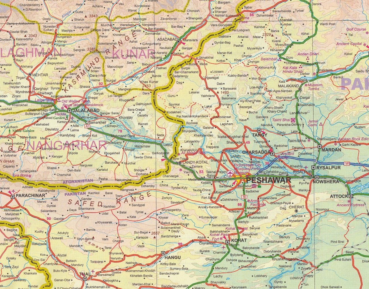
🏞️ Regional Map of Khyber Pass & Greater Afghanistan (Scale 1:1,000,000)
The reverse side presents a broad-scale map of eastern Afghanistan and northwest Pakistan, focusing on the historic Khyber Pass—a key trade and invasion route used since antiquity.
-
🌄 Geographic Highlights – Mountain ranges, river valleys, desert expanses
-
🛤️ Cross-Border Routes – Highway networks between Kabul, Jalalabad, Peshawar, and beyond
-
🏰 Cultural and Historical Sites – The Khyber forts, ancient trading routes, traditional Pashtun villages
-
🔍 Inset Focus Areas – Additional context around areas of strategic or cultural interest
This regional map gives excellent context to the historical and modern importance of the area, including tribal regions, border dynamics, and terrain complexities.
🔍 Map Features
-
✅ Double-sided format: Kabul city on one side, regional overview on the other
-
✅ Clean and up-to-date cartographic design
-
✅ Clearly marked roads, highways, and international borders
-
✅ Important government buildings and infrastructure
-
✅ Relief shading to show topography and elevation
-
✅ Index of key place names and landmarks
💧 Optional Lamination Available
For durability and practicality, you can opt for a laminated version of this map:
-
✏️ Write-on/wipe-off surface – Plan routes or mark positions using whiteboard markers
-
💦 Waterproof and tear-resistant – Ideal for fieldwork, travel, or classroom use
-
💪 Encapsulated with 80-micron gloss laminate for a robust, reusable finish
Note: Laminated maps are created by flattening the original folded version before sealing them in laminate. Slight fold lines will still be visible.
📐 Specifications
| Feature | Details |
|---|---|
| Title | Kabul & Historic Khyber Pass Map |
| Publisher | ITMB – International Travel Maps |
| Map Coverage | Kabul (City) / Afghanistan & Khyber Region |
| Scales | 1:16,500 (Kabul) / 1:1,000,000 (Regional) |
| Size | 690 mm x 1000 mm |
| Format | Folded paper map (optional laminated) |
| Print Type | Double-sided, full colour |
🎯 Who’s It For?
-
🧭 Fieldworkers & NGOs operating in Afghanistan or Pakistan
-
🏛️ Military families and personnel seeking regional understanding
-
🎒 Adventure travellers and cultural explorers
-
🧠 Academics, historians, and educators focused on South-Central Asia
-
📷 Documentarians and journalists covering regional stories
This is not just a map—it’s a rare geographic reference to one of the world’s most storied crossroads. Whether you’re navigating the streets of Kabul, tracing the caravan routes of the Silk Road, or planning humanitarian missions, the Kabul & Historic Khyber Pass ITMB Map is your indispensable companion.
Frequently Asked Questions
Where can I buy the Kabul & Historic Khyber Pass ITMB Map?
The Kabul & Historic Khyber Pass ITMB Map is available to buy online from Mapworld, Australia's largest map and geographic product retailer, with fast shipping Australia-wide.
Is the Kabul & Historic Khyber Pass ITMB Map in stock at Mapworld?
Mapworld maintains extensive stock across its map range and aims for fast dispatch. Orders placed before 2pm AEST on business days are typically dispatched the same day, with standard and express Australia-wide delivery options available.
What is Mapworld's returns policy?
Mapworld accepts returns on undamaged items in original condition. Contact Mapworld within 90 days of purchase to arrange a return or exchange.
Does Mapworld ship the Kabul & Historic Khyber Pass ITMB Map across Australia?
Yes, Mapworld ships Australia-wide. Standard shipping is a flat $7 rate, with free standard shipping on orders over $75. Express options are available at checkout. Most orders placed before 2pm AEST on weekdays are dispatched same day.
Related Items


© 2026 Mapworld. Website designed by Genie Media
X