Focused Regional Detail | Physical & Political Layers | Premium Finishes
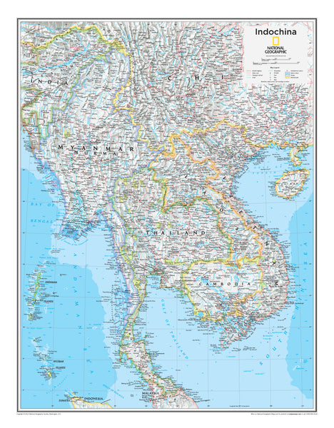
Discover the heart of Southeast Asia with National Geographic’s Indochina Wall Map—a refined blend of cartographic precision and timeless design. From the Mekong River to the shores of the South China Sea and Gulf of Thailand, this map reveals a region with a rich, complex history and dynamic, modern economies. It’s a striking statement piece for homes, offices, classrooms, and studios.
🗺️ Features & Highlights
-
Comprehensive Regional Coverage: Centers on Vietnam, Laos, and Cambodia, with surrounding context for Thailand, Myanmar, southern China, and peninsular Malaysia.
-
Physical + Political Cartography: Clearly delineated international and internal boundaries overlaid on terrain with shaded relief, rivers, lakes, and coastlines.
-
Major Cities & Landmarks: Labels for Hanoi, Ho Chi Minh City, Phnom Penh, Vientiane, the Mekong Delta, Tonlé Sap, and the Angkor region.
-
Infrastructure at a Glance: Major highways, roads, rail lines, airports, and ports help visualize regional connectivity.
-
Elegant National Geographic Style: Classic color palette, clear typography, and meticulous detail make it both decorative and educational.
✨ Available Finishes
| Format | Description |
|---|---|
| 📜 Paper (160 gsm) | Heavyweight matte-coated paper—perfect for framing under glass. |
| 🧼 Laminated (Encapsulated) | Fully sealed in 80-micron gloss laminate for a durable, wipe-clean surface—ideal for classrooms and high-traffic areas. |
| 🪵 Laminated with Wooden Hang Rails | Laminated map mounted with lacquered natural timber rails (top & bottom) and a sturdy hanging cord—arrives ready to display. |
| 🖼️ Canvas (395 gsm) | HP Professional Matte Canvas printed with archival pigment inks—rich texture, fade-resistant, gallery-quality. |
| 🪵 Canvas with Wooden Hang Rails | Canvas mounted with timber rails and hanging cord—no frame needed for a timeless, exhibition-style presentation. |
🔨 Note: Hang-railed maps are custom mounted—please allow up to 10 working days.
📐 Specifications
| Feature | Detail |
|---|---|
| Title | Indochina National Geographic Wall Map |
| Map Type | Physical & Political |
| Dimensions | 711 mm (W) × 559 mm (H) |
| Materials | Paper, Laminated, Canvas; with/without Timber Rails |
| Printing | Pigment-based, fade-resistant inks |
| Made In | Australia |
🎁 Perfect For
-
Home & Office Décor: A sophisticated focal point with cultural depth.
-
Education & Research: Ideal for teaching geography, history, and regional studies.
-
Travel & Business Planning: Visualize routes, hubs, and regional connections across mainland Southeast Asia.
🚚 Delivery
-
Paper, Laminated, Canvas (rolled): Typically ship within 1–2 business days.
-
Hang-Railed Maps: Made to order—please allow up to 10 working days.
-
Secure Packaging: Carefully packed to arrive in pristine condition.
Celebrate the culture, history, and momentum of Indochina with National Geographic cartography.
Add to cart and bring Southeast Asia’s story to your wall.


