- Australia ▾
- Topographic
▾
- Australia AUSTopo 250k (2025)
- Australia 50k Geoscience maps
- Australia 100k Geoscience maps
- Australia 250k Geoscience maps
- Australia 1:1m Geoscience maps
- New Zealand 50k maps
- New Zealand 250k maps
- New South Wales 25k maps
- New South Wales 50k maps
- New South Wales 100k maps
- Queensland 10k maps
- Queensland 25k maps
- Queensland 50k maps
- Queensland 100k maps
- Compasses
- Software
- GPS Systems
- Orienteering
- International ▾
- Wall Maps
▾
- World
- Australia & New Zealand
- Countries, Continents & Regions
- Historical
- Vintage National Geographic
- Australian Capital Territory
- New South Wales
- Northern Territory
- Queensland
- South Australia
- Tasmania
- Victoria
- Western Australia
- Celestial
- Children's
- Mining & Resources
- Wine Maps
- Healthcare
- Postcode Maps
- Electoral Maps
- Nautical ▾
- Flags
▾
- Australian Flag Sets & Banners
- Flag Bunting
- Handwavers
- Australian National Flags
- Aboriginal Flags
- Torres Strait Islander Flags
- International Flags
- Flagpoles & Accessories
- Australian Capital Territory Flags
- New South Wales Flags
- Northern Territory Flags
- Queensland Flags
- South Australia Flags
- Tasmania Flags
- Victoria Flags
- Western Australia Flags
- Gifts ▾
- Globes ▾
Dear valued customer. Please note that our checkout is not supported by old browsers. Please use a recent browser to access all checkout capabilities


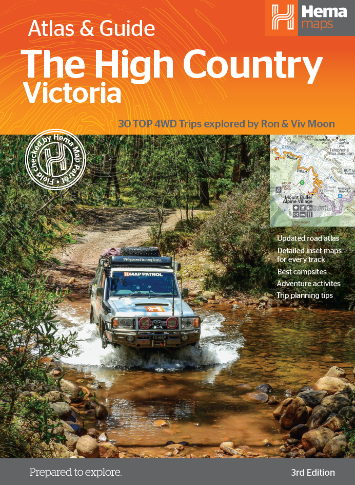
High Country Victoria Atlas & Guide Hema
$49.95
Afterpay is only available for orders between $50.00 and $1000.00 More info
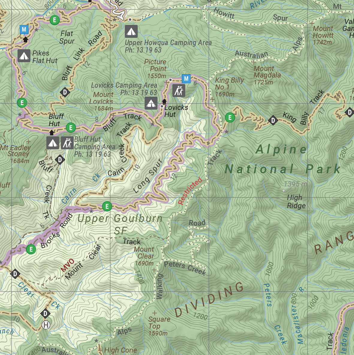
A comprehensive adventure guide to one of Australia's most breathtaking and remote regions – with expert 4WD advice, topographic maps, and detailed travel tips
The Victorian High Country Atlas & Guide, now in its 3rd Edition, is Hema’s most detailed and practical publication for anyone wanting to explore Victoria’s legendary alpine and backcountry regions. Created in collaboration with well-known 4WD adventurers Ron and Viv Moon, this spiral-bound guidebook is a trusted reference for overlanders, campers, hikers, and nature lovers looking to access the High Country's rugged terrain, river valleys, remote campsites, and historical trails.
Spanning everything from iconic 4WD tracks to alpine peaks, from the Great Alpine Road to remote wilderness trails in Snowy River National Park, this atlas offers a rich blend of practical navigation, regional insights, and first-hand experience.
🗺️ What's Inside: Key Features
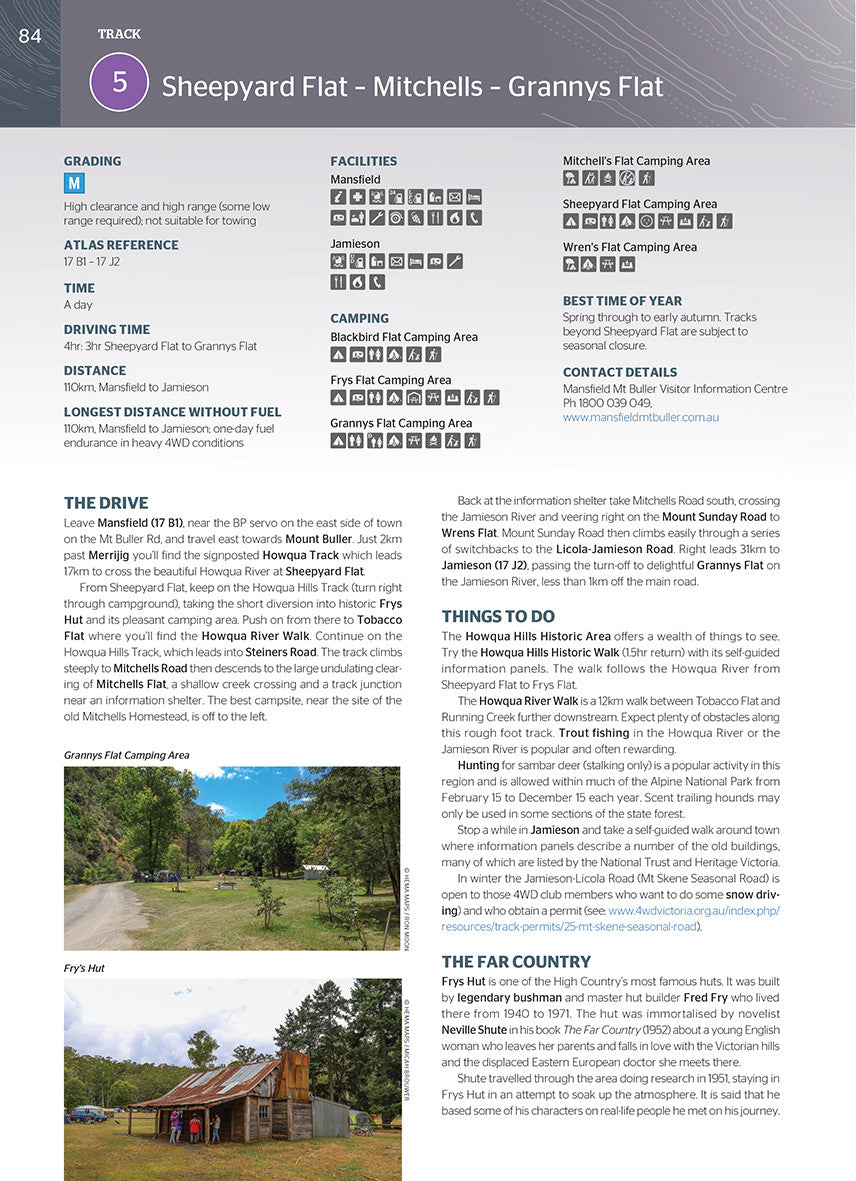
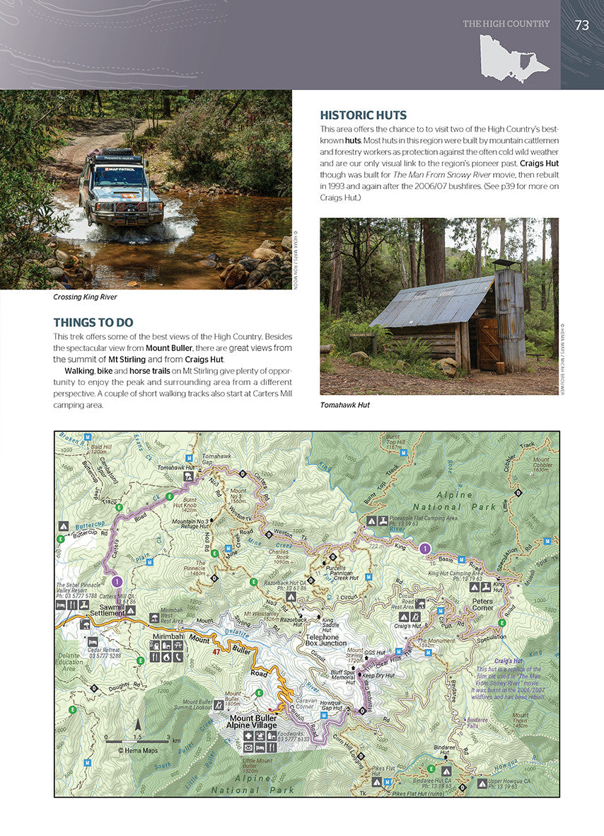
🚙 30 Best 4WD Adventures – Handpicked by the Experts
-
Written by veteran outback explorers Ron and Viv Moon, the 30 featured routes cater to a variety of skill levels — from beginner to advanced 4WDers
-
Each route includes:
-
Track notes and distances
-
Grading and difficulty levels
-
Fuel stops and access conditions
-
Camping recommendations and facilities
-
Warnings for seasonal closures, water crossings, and road surface changes
-
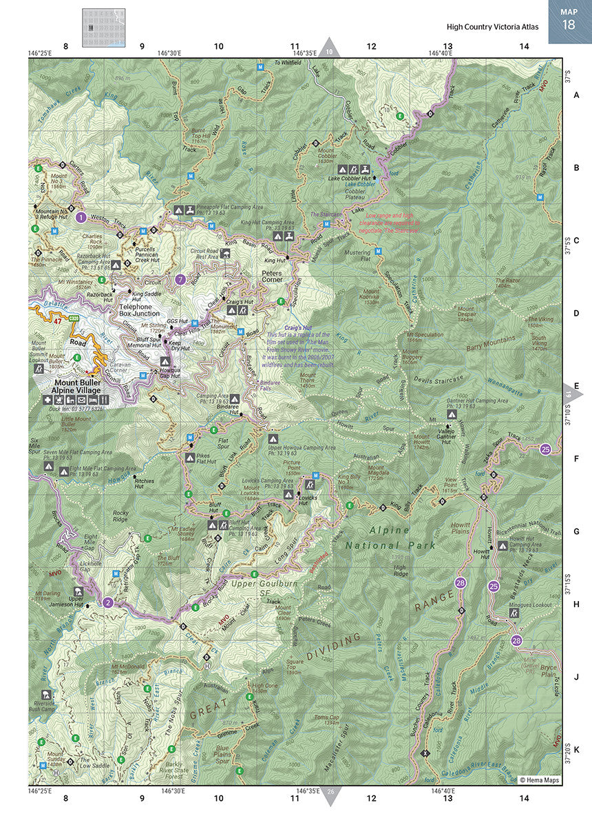
🧭 Atlas Mapping – Clear, Reliable & Up-To-Date
-
40 pages of Hema’s renowned topographic mapping
-
Map scale: 1:150,000 – ideal for off-road navigation and route planning
-
Shows 4WD tracks, fire trails, walking tracks, rivers, altitude contours, and campsites
🌄 Extensive Regional Coverage
Explore the full scope of the High Country, including:
-
Mansfield, Bright, Omeo, Walhalla, Dargo, Licola, Mt Hotham, Falls Creek, and Mt Buller
-
Snowy River National Park
-
Alpine National Park
-
Baw Baw and Avon Wilderness Parks
-
Lakes Entrance and the Gippsland Lakes
-
Great Alpine Road, Barry Way, Crooked River Track, and Wonnangatta Valley
🌿 Nature & Cultural Insights
-
Learn about the flora, fauna, geology, and Indigenous and colonial history of the High Country
-
Includes information on historic huts, gold mining ruins, and the pioneering legends of the region
-
Useful climate and seasonal tips to help you prepare for variable alpine weather conditions
📖 Guidebook Specifications
-
Edition: 3rd
-
Published: April 2017
-
Format: A4, spiral-bound
-
Pages: 208 pages packed with info, photos, and maps
-
Dimensions: 297 mm x 210 mm (A4 landscape)
-
Weight: Approx. 1 kg
-
ISBN: 9781876413149
-
Publisher: Hema Maps
🎯 Who It’s For
-
4WD and touring enthusiasts looking to explore beyond the blacktop
-
Campers and caravanners seeking remote alpine sites with clear access info
-
Hikers and nature lovers interested in the walking trails and natural history of Victoria’s mountain ranges
-
Geography teachers and school groups studying Victorian ecosystems and geography
-
Travellers seeking the best combination of recreation, wilderness, and history
✅ Why Choose This Guide?
-
Trusted by thousands of off-road adventurers, grey nomads, and weekend warriors
-
Combines Hema’s award-winning cartography with local knowledge and years of field-tested experience
-
Easy to use in vehicles with lay-flat spiral binding and tough pages
-
Helps you travel smarter, safer, and with greater confidence
-
Excellent companion to GPS systems or apps, especially in remote areas with poor reception
-
Makes a thoughtful gift for any outdoor enthusiast or new 4WD owner
Breathtaking alpine scenery. River crossings and remote trails. History in every stone hut and mining relic.
The High Country Victoria Atlas & Guide is your key to unlocking the spirit of adventure in one of Australia’s most scenic and remote playgrounds.
Take the high road, plan your route, and go further — with Hema.
Frequently Asked Questions
What does the High Country Victoria Atlas & Guide Hema cover?
This atlas covers the geographic region indicated in the product title, including roads, towns, distances, and key travel information. Mapworld stocks atlases for Australian states and territories, 4WD regions, and international destinations.
Is this the latest edition?
Yes, this is the latest edition. Mapworld stocks the most current editions available from publishers.
Is this atlas or guide spiral bound?
Spiral binding is indicated in the product title where applicable. Spiral-bound atlases and guides lay flat when open, making them ideal for use in vehicles or on a table without needing to hold pages open.
Is the High Country Victoria Atlas & Guide Hema in stock at Mapworld?
Mapworld maintains extensive stock across its map range and aims for fast dispatch. Orders placed before 2pm AEST on business days are typically dispatched the same day, with standard and express Australia-wide delivery options available.
Does Mapworld ship the High Country Victoria Atlas & Guide Hema across Australia?
Yes, Mapworld ships Australia-wide. Standard shipping is a flat $7 rate, with free standard shipping on orders over $75. Express options are available at checkout. Most orders placed before 2pm AEST on weekdays are dispatched same day.
Related Items


© 2026 Mapworld. Website designed by Genie Media
X