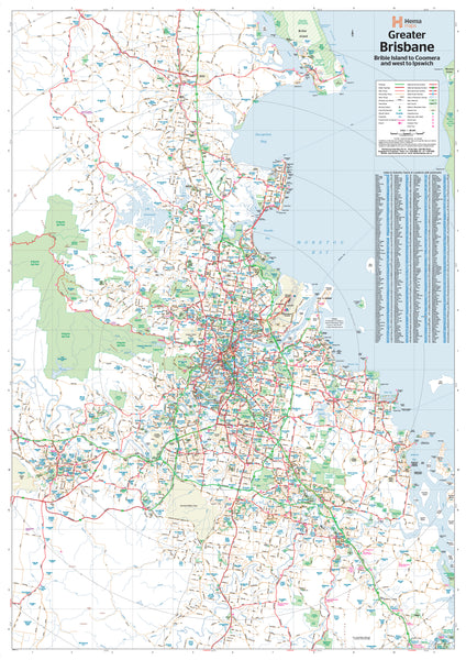
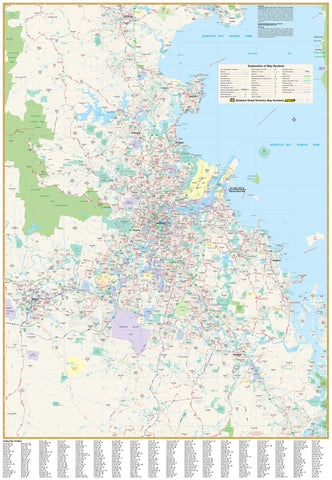
Explore, plan, and visualise South East Queensland’s most important urban region in exceptional detail.
The Greater Brisbane Map by Hema offers a high-resolution, professionally designed representation of the entire Brisbane metropolitan region. Covering major suburbs, arterial routes, and future infrastructure developments, this map is an essential resource for business planning, educational use, logistics, and home reference.
From the sun-drenched beaches of Bribie Island in the north, down through the rapidly growing southern suburbs of Logan and Jimboomba, and west to Ipswich, this comprehensive map captures the full spatial scope of Australia’s third-largest city and the diverse communities that make up its metropolitan fabric.
🗺️ Map Coverage
This large-format wall map includes detailed coverage of:
-
Brisbane City and Inner Suburbs – including the CBD, South Brisbane, Fortitude Valley, and surrounds
-
Northern Corridor – Bribie Island, Caboolture, Morayfield, North Lakes, and Redcliffe Peninsula
-
Southern Growth Belt – Logan Central, Jimboomba, Beenleigh, and Greenbank
-
Western Brisbane and Ipswich Region – Springfield, Ripley, Goodna, and Ipswich proper
-
Eastern Suburbs and Bayside – Wynnum, Manly, Cleveland, Redland Bay, and Victoria Point
-
Surrounding Local Government Areas: Including Moreton Bay, Logan, Redland, and Ipswich City Councils
📍 Key Map Features
-
Road Networks:
-
Full delineation of major highways, arterial and secondary roads, as well as present and proposed freeway alignments
-
Includes Met Roads, State Routes, and National Route numbers
-
-
Suburb and Postcode Information:
-
Every suburb is labelled with its postcode boundary, essential for delivery planning, real estate, and area zoning
-
Indexed list of suburbs ensures quick lookup and navigation
-
-
Infrastructure and Landmarks:
-
Schools, hospitals, universities, shopping centres, airports, and major recreational facilities
-
Public transport corridors including train lines, busways, and ferry terminals
-
Parks, forests, waterways, and green corridors
-
-
Urban Structure:
-
Built-up areas distinguished from undeveloped or natural regions
-
Industrial zones and future development corridors clearly indicated
-
Coastal and riverine detail for the Brisbane River and Moreton Bay
-
🖨️ Print & Laminate Quality
Crafted with the same quality and attention to detail Hema is known for, this map is:
-
Printed on 120 gsm FSC matte-coated paper – smooth, glare-free finish ideal for up-close viewing
-
Uses pigment-based, fade-resistant inks – long-lasting, high-definition colour
-
Laminated between two 80-micron gloss sheets – ensuring complete encapsulation for:
-
Waterproofing
-
Tear-resistance
-
UV and moisture protection
-
Compatibility with whiteboard markers and Mark-It-Dots (non-permanent location markers)
-
📐 Map Specifications
-
Scale: 1:100,000 – suitable for suburb-level road detail and regional overview
-
Size: 700 mm (W) × 1000 mm (H)
-
Orientation: Portrait
-
Made in: Australia
-
Publisher: Hema Maps
-
Edition: Most recent available
🛒 Purchase Options
-
Flat Laminated Map – $99.00
-
Delivered rolled in a sturdy mailing tube
-
Ideal for wall mounting or framing
-
Perfect for offices, planning spaces, or educational settings
-
-
Laminated Folded Map – $45.00
-
A professionally laminated version of a previously folded map
-
Some crease lines may be visible, but it retains full durability and clarity
-
A budget-friendly, practical solution for business or casual use
-
🎯 Ideal Applications
-
Business Owners & Logistics Teams: Plan delivery areas, sales territories, or service zones with postcode accuracy
-
Town Planners and Developers: Visualise growth corridors, zoning boundaries, and infrastructure planning
-
Educators and Classrooms: Teach local geography, planning, and transport systems
-
Home Offices and Study Spaces: Explore Brisbane’s structure, suburbs, and transport links
-
Real Estate Professionals: Reference zoning, pricing catchments, and accessibility
-
Tourism and Hospitality Operators: Map travel corridors, accommodation hubs, and attractions
-
Government and Community Organisations: Understand jurisdictional boundaries and service delivery areas
🖼️ Optional Canvas Display
Want a high-end presentation? This map is also available on archival-quality canvas, which can be fitted with:
-
Natural timber hang rails, top and bottom
-
A discreet hanging cord for quick wall installation
-
Lacquered finish for a clean, modern aesthetic
-
Please allow up to 10 business days for custom finishing by our framing team
🌟 Why Choose the Greater Brisbane Map by Hema?
-
Produced by Australia’s most trusted mapmaker
-
Field-verified for accuracy and continually updated
-
Combines visual clarity, cartographic precision, and practical design
-
Built for real-world use—across offices, classrooms, government departments, and homes
Plan smarter. Display proudly. Understand your region.
The Greater Brisbane Wall Map by Hema isn’t just a visual aid—it’s a professional-grade resource for anyone working with or within South East Queensland.
Order yours today and put Brisbane in full view.


