- Australia ▾
- Topographic
▾
- Australia AUSTopo 250k (2025)
- Australia 50k Geoscience maps
- Australia 100k Geoscience maps
- Australia 250k Geoscience maps
- Australia 1:1m Geoscience maps
- New Zealand 50k maps
- New Zealand 250k maps
- New South Wales 25k maps
- New South Wales 50k maps
- New South Wales 100k maps
- Queensland 10k maps
- Queensland 25k maps
- Queensland 50k maps
- Queensland 100k maps
- Western Australia 25k maps
- Western Australia 50k maps
- Western Australia 100k maps
- Compasses
- Software
- GPS Systems
- International ▾
- Wall Maps
▾
- World
- Australia & New Zealand
- Countries, Continents & Regions
- Historical
- Vintage National Geographic
- Australian Capital Territory
- New South Wales
- Northern Territory
- Queensland
- South Australia
- Tasmania
- Victoria
- Western Australia
- Celestial
- Children's
- Mining & Resources
- Wine Maps
- Healthcare
- Postcode Maps
- Electoral Maps
- Nautical ▾
- Flags
▾
- Australian Flag Sets & Banners
- Flag Bunting
- Handwavers
- Australian National Flags
- Aboriginal Flags
- Torres Strait Islander Flags
- International Flags
- Flagpoles & Accessories
- Australian Capital Territory Flags
- New South Wales Flags
- Northern Territory Flags
- Queensland Flags
- South Australia Flags
- Tasmania Flags
- Victoria Flags
- Western Australia Flags
- Gifts ▾
- Globes ▾
Dear valued customer. Please note that our checkout is not supported by old browsers. Please use a recent browser to access all checkout capabilities


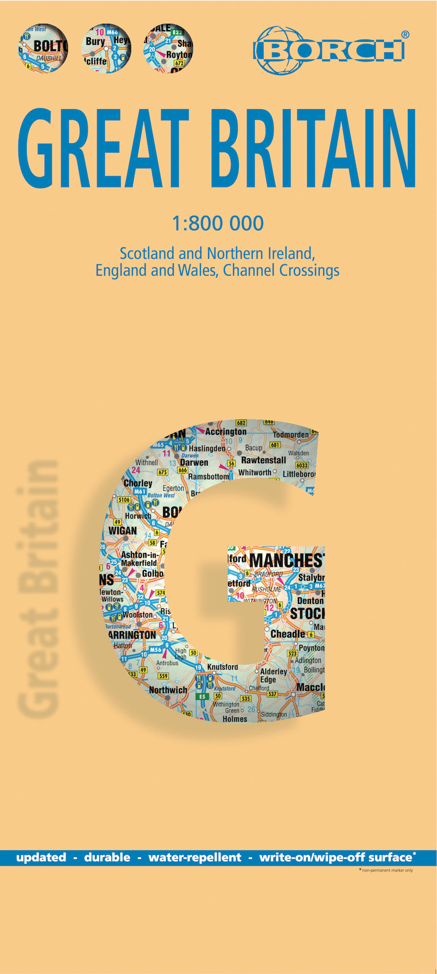
Great Britain Borch Folded Laminated Map
$21.95
Afterpay is only available for orders between $50.00 and $1000.00 More info
🇬🇧 Great Britain Borch Folded Laminated Map
Durable, Foldable, and Fully Indexed – A Perfect Companion for Touring the UK
Explore the full breadth of England, Scotland, and Wales with this 13th edition Borch laminated road map of Great Britain, designed for clarity, resilience, and easy use on the go. Whether you're road-tripping through the Highlands, navigating the scenic coasts of Cornwall, or planning your route across the English countryside, this soft-laminated, weather-resistant map is built for adventure.
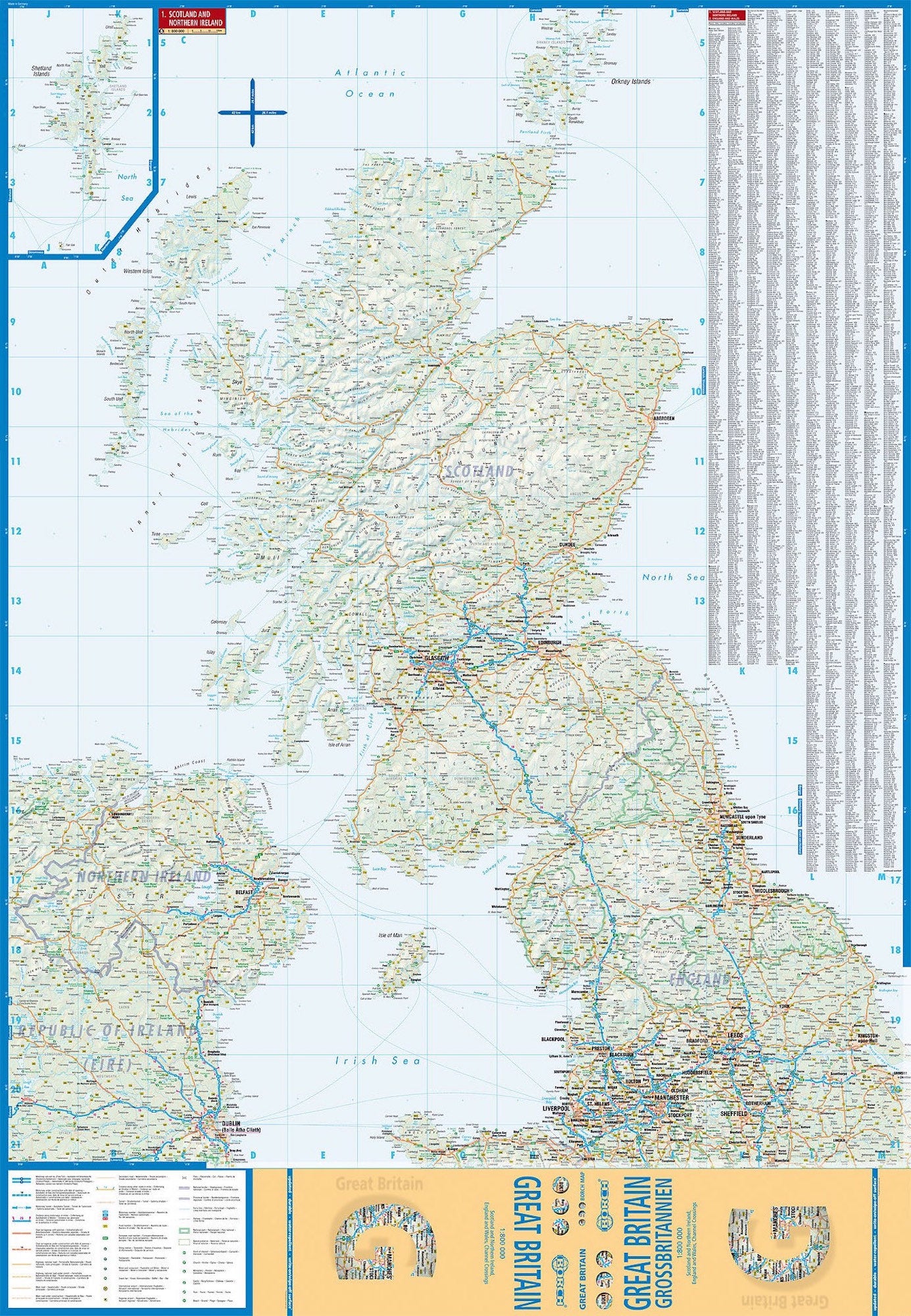
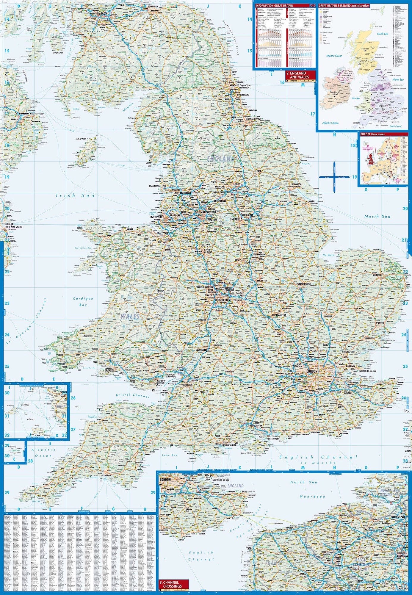
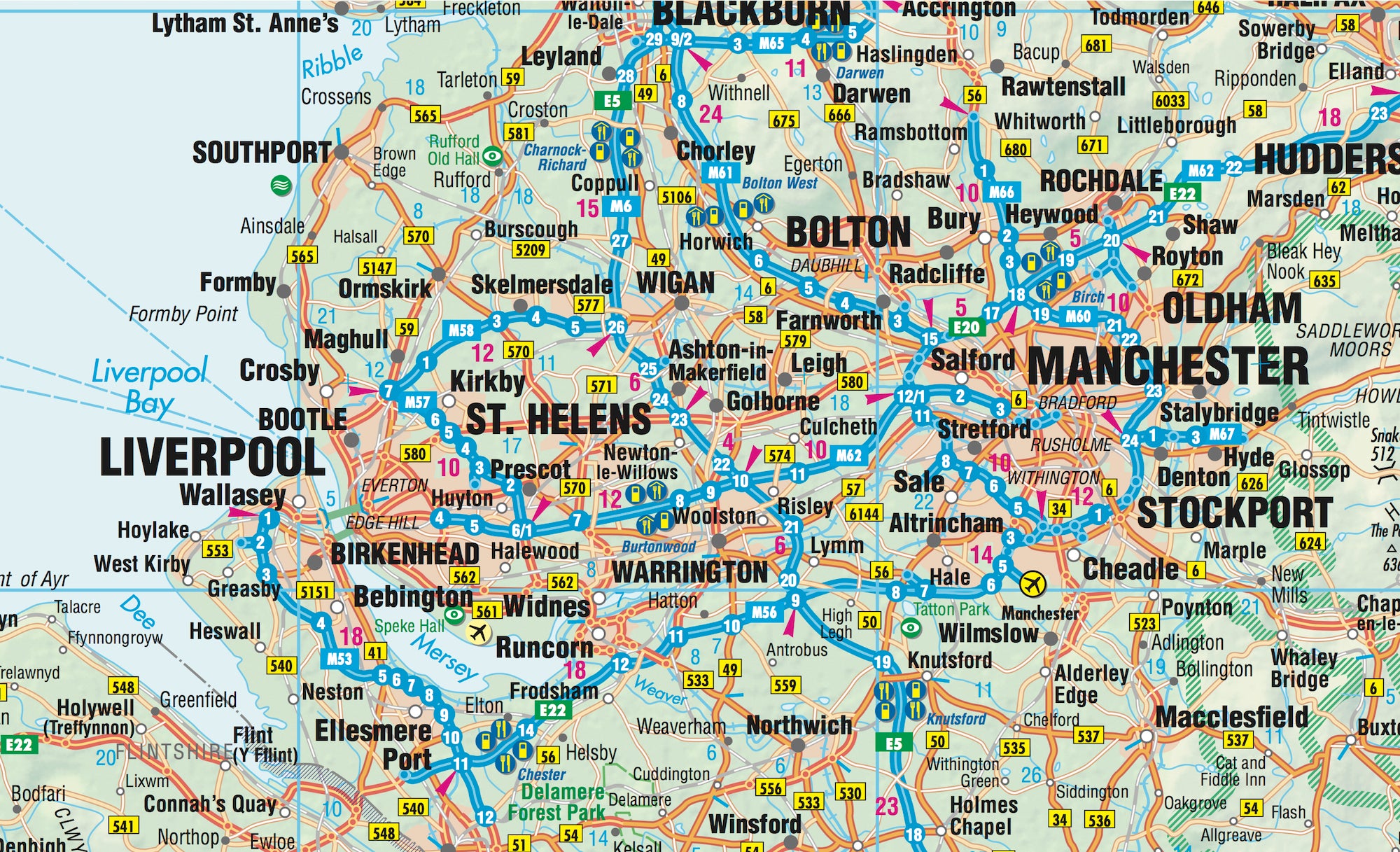
🗺️ Map Coverage & Detail
This comprehensive map offers broad regional coverage and highly useful reference maps:
-
Main Map:
-
Great Britain at 1:800,000 scale – Includes England, Scotland, and Wales
-
-
Inset Maps:
-
Channel Crossings – Major ferry routes across the English Channel
-
Administrative Overview – Great Britain & Ireland political divisions
-
Europe Time Zones – A handy reference for international travel
-
🔍 Map Features
Borch maps are known for their exceptional legibility and user-friendly design, ideal for both casual visitors and serious trip planners. Features include:
-
Tourist highlights: monuments, museums, historic landmarks, castles, ruins
-
Natural attractions: viewpoints, scenic routes, coastlines
-
Public transport routes and symbols
-
Climate charts: monthly averages for sunshine, temperature, and rainfall
-
Metric conversions: handy tables for weights, measures, and temperatures
-
Fully indexed with cities, towns, and major points of interest
📐 Specifications
| Specification | Detail |
|---|---|
| Map Title | Great Britain |
| Publisher | Borch Maps |
| Edition | 13th Edition (2014) |
| ISBN | 978-3-86609-315-7 |
| Scale | 1:800,000 |
| Map Size (unfolded) | 990 mm x 685 mm (39 in x 27 in) |
| Folded Size | 243 mm x 110 mm x 10 mm |
| Weight | 103 g (3.6 oz) |
| Format | Folded, soft-laminated road map |
💡 Why Choose a Borch Map?
-
✅ Soft-laminated: Water-repellent, wipe-clean surface
-
✅ Tear-resistant: Designed to endure the wear and tear of travel
-
✅ Easily foldable: Smooth refolding, unlike bulky plastic maps
-
✅ Full of detail: Ideal for road trips, cultural exploration, or trip planning
🌍 About Great Britain
The island of Great Britain encompasses England, Scotland, and Wales, along with surrounding smaller islands such as the Hebrides, Isle of Wight, Anglesey, Isles of Scilly, Orkney, and Shetland. With rugged mountain ranges in the north and west, and gently rolling green meadows in the south and east, the landscape is as varied as its deep cultural heritage.
Whether you're chasing Shakespeare’s trails in Stratford-upon-Avon, climbing Ben Nevis, or enjoying Cornish pasties in St Ives, this map provides the practical detail and visual clarity needed to make the most of your journey.
Frequently Asked Questions
Where can I buy the Great Britain Borch Folded Laminated Map?
The Great Britain Borch Folded Laminated Map is available to buy online from Mapworld, Australia's largest map and geographic product retailer, with fast shipping Australia-wide.
Is the Great Britain Borch Folded Laminated Map in stock at Mapworld?
Mapworld maintains extensive stock across its map range and aims for fast dispatch. Orders placed before 2pm AEST on business days are typically dispatched the same day, with standard and express Australia-wide delivery options available.
What is Mapworld's returns policy?
Mapworld accepts returns on undamaged items in original condition. Contact Mapworld within 90 days of purchase to arrange a return or exchange.
Does Mapworld ship the Great Britain Borch Folded Laminated Map across Australia?
Yes, Mapworld ships Australia-wide. Standard shipping is a flat $7 rate, with free standard shipping on orders over $75. Express options are available at checkout. Most orders placed before 2pm AEST on weekdays are dispatched same day.
Related Items


© 2026 Mapworld. Website designed by Genie Media
X