- Australia ▾
- Topographic
▾
- Australia AUSTopo 250k (2024)
- Australia 50k Geoscience maps
- Australia 100k Geoscience maps
- Australia 250k Geoscience maps
- Australia 1.1m Geoscience maps
- New Zealand 50k maps
- New Zealand 250k maps
- New South Wales 25k maps
- New South Wales 50k maps
- New South Wales 100k maps
- Queensland 10k maps
- Queensland 25k maps
- Queensland 50k maps
- Queensland 100k maps
- Compasses
- Software
- GPS Systems
- Orienteering
- International ▾
- Wall Maps
▾
- World
- Australia & New Zealand
- Countries, Continents & Regions
- Historical
- Vintage National Geographic
- Australian Capital Territory
- New South Wales
- Northern Territory
- Queensland
- South Australia
- Tasmania
- Victoria
- Western Australia
- Celestial
- Children's
- Mining & Resources
- Wine Maps
- Healthcare
- Postcode Maps
- Electoral Maps
- Nautical ▾
- Flags
▾
- Australian Flag Sets & Banners
- Flag Bunting
- Handwavers
- Australian National Flags
- Aboriginal Flags
- Torres Strait Islander Flags
- International Flags
- Flagpoles & Accessories
- Australian Capital Territory Flags
- New South Wales Flags
- Northern Territory Flags
- Queensland Flags
- South Australia Flags
- Tasmania Flags
- Victoria Flags
- Western Australia Flags
- Gifts ▾
- Globes ▾
Dear valued customer. Please note that our checkout is not supported by old browsers. Please use a recent browser to access all checkout capabilities


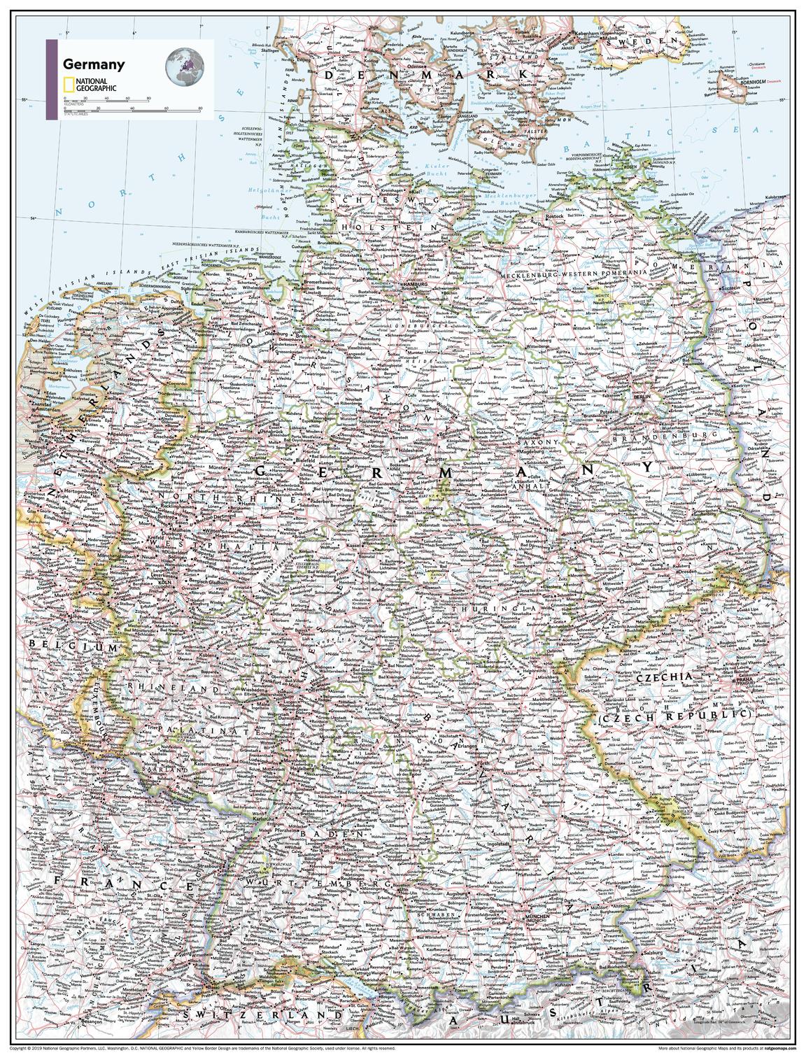
Germany Atlas of the World, 11th Edition, National Geographic Wall Map
$69.95
or make 4 interest-free payments of
$17.49 AUD
fortnightly with
![]() More info
More info
🇩🇪 Germany Wall Map – National Geographic
Atlas of the World, 11th Edition – 2019
Sizes: 790 × 610 mm (Standard) | 915 × 1197 mm (Supermap)
📍 Cartographic Excellence. Iconic Design. Timeless Detail.
Bring the rich geography, cultural complexity, and precision of Germany to your wall with this stunning National Geographic wall map — drawn from the prestigious 11th Edition Atlas of the World. This beautifully crafted physical and political map blends aesthetic charm with scientific detail, capturing Germany’s iconic topography, cities, and borders in all their clarity.
Whether you're teaching, travelling, decorating, or dreaming — this map inspires curiosity and delivers insight. From the peaks of the Bavarian Alps to the winding Elbe and Rhine, every feature is mapped with elegance and intent.
✨ Why You'll Love This Map
✅ Authoritative Cartography – Produced by the National Geographic Society, one of the world’s most trusted mapmakers for over 120 years.
✅ Vivid Relief & Political Detail – Clearly defined Bundesländer, state capitals, transport routes, rivers, mountain ranges, and neighbouring nations.
✅ A Work of Art – Blue seas, shaded terrain, and a warm, readable colour palette make this map as beautiful as it is informative.
✅ Ideal for Home, Office or Classroom – Inspire learning, decorate with intention, or plan your next adventure.
📐 Specifications at a Glance
| Feature | Details |
|---|---|
| Map Title | Germany – National Geographic Atlas of the World, 11th Edition |
| Cartographer | National Geographic Society |
| Edition | 2019 |
| Projection | Albers Conic Equal-Area – ideal for depicting the country’s full spread |
| Features Included | State boundaries, cities, rivers, mountains, forests, road & rail networks |
| Labeling | Clear and legible names for towns, rivers, ranges, and key geographic points |
| Language | English |
| Inset Maps | Full country view with accurate borders and neighbouring context |
🖨️ Format & Material Options
| Format | Material | Finish & Use |
|---|---|---|
| 🗺️ Paper (Unlaminated) | 160 gsm premium matte-coated paper | Ideal for framing behind glass — elegant and glare-free |
| 💧 Laminated | Encapsulated in dual 80-micron gloss film | Wipeable, durable, water-resistant — perfect for daily use |
| 🖼️ Canvas | 395 gsm HP Professional Matte Canvas | Soft-textured, gallery-quality – luxurious and long-lasting |
| 🪵 Laminated + Timber Rails | Laminated map with top & bottom wooden rails | Ready to hang – great for offices and classrooms |
| 🪵 Canvas + Timber Rails | Canvas map with top & bottom wooden rails | A showpiece – perfect for homes, libraries, or executive spaces |
📏 Available Sizes
| Size | Dimensions (W × H) | Recommended For |
|---|---|---|
| Standard | 790 × 610 mm | Desks, study nooks, classrooms, apartments |
| Supermap | 915 × 1197 mm | Living rooms, meeting spaces, libraries, galleries |
🚚 Delivery & Mounting
-
🛠️ Optional Wooden Hang Rails are lacquered in a natural timber finish and include a top hanging cord.
-
⏳ Please allow 10 working days for delivery of hang-railed maps – professionally framed by hand in Australia.
-
📦 Maps are shipped rolled.
🌍 Who This Map is For
-
Educators bringing German geography alive for students.
-
Travellers planning their next road trip through the Black Forest or along the Romantic Road.
-
History lovers connecting to Germany’s diverse regions and borders.
-
Professionals needing a practical and beautiful reference for business or research.
-
Home decorators looking to add intelligent, European flair to a living or study space.
Discover Germany through the lens of National Geographic — where precision meets inspiration.


