- Australia ▾
- Topographic
▾
- Australia AUSTopo 250k (2024)
- Australia 50k Geoscience maps
- Australia 100k Geoscience maps
- Australia 250k Geoscience maps
- Australia 1.1m Geoscience maps
- New Zealand 50k maps
- New Zealand 250k maps
- New South Wales 25k maps
- New South Wales 50k maps
- New South Wales 100k maps
- Queensland 10k maps
- Queensland 25k maps
- Queensland 50k maps
- Queensland 100k maps
- Compasses
- Software
- GPS Systems
- Orienteering
- International ▾
- Wall Maps
▾
- World
- Australia & New Zealand
- Countries, Continents & Regions
- Historical
- Vintage National Geographic
- Australian Capital Territory
- New South Wales
- Northern Territory
- Queensland
- South Australia
- Tasmania
- Victoria
- Western Australia
- Celestial
- Children's
- Mining & Resources
- Wine Maps
- Healthcare
- Postcode Maps
- Electoral Maps
- Nautical ▾
- Flags
▾
- Australian Flag Sets & Banners
- Flag Bunting
- Handwavers
- Australian National Flags
- Aboriginal Flags
- Torres Strait Islander Flags
- International Flags
- Flagpoles & Accessories
- Australian Capital Territory Flags
- New South Wales Flags
- Northern Territory Flags
- Queensland Flags
- South Australia Flags
- Tasmania Flags
- Victoria Flags
- Western Australia Flags
- Gifts ▾
- Globes ▾
Dear valued customer. Please note that our checkout is not supported by old browsers. Please use a recent browser to access all checkout capabilities


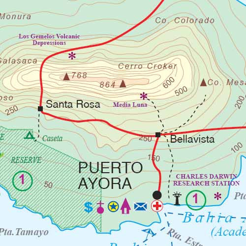
Galapagos Islands Quito & Guayaquil ITMB Map
$24.95
Afterpay is only available for orders between $50.00 and $1000.00 More info
Explore One of the World’s Most Unique Ecosystems—With the Cities That Get You There
Whether you're chasing the footsteps of Darwin or planning the trip of a lifetime, this double-sided travel map from ITMB is the perfect tool for planning and navigating your Galápagos adventure. Thoughtfully designed to include the remote Galápagos archipelago and Ecuador’s two main international gateways—Quito and Guayaquil—this map is a must-have for travellers seeking the full picture.
Printed on durable paper and featuring detailed cartographic information, it blends natural wonder with practical logistics to help you make the most of your journey.
🌋 Side A – The Galápagos Islands + Guayaquil Inset
-
Scale: 1:420,000 (main islands)
-
Covers the entire Galápagos archipelago, including:
-
Santa Cruz, San Cristóbal, Isabela, Fernandina, Floreana, and lesser-known islands.
-
Locations of wildlife hotspots including marine iguanas, sea lions, Galápagos tortoises, and blue-footed boobies.
-
Detailed representation of national park zones, walking trails, and cruise access points.
-
The main town of Puerto Ayora, plus smaller communities and visitor sites.
-
-
Inset Map of Guayaquil – A useful reference for travellers connecting via Ecuador’s main coastal city.
🛳️ Only authorised tours are allowed in the Galápagos Islands. This map includes likely wildlife viewing areas and routes used by cruise vessels, but travellers must follow official tour guidelines.
🏙️ Side B – Quito & Region
-
Scales:
-
1:12,500 – Full city map
-
1:7,500 – Quito Centre
-
-
Shows:
-
Major streets, plazas, parks, historic landmarks, and attractions.
-
Public transport routes and key roads to Mariscal Sucre International Airport (located well outside the city).
-
Tourist-friendly features such as hotel zones, museums, markets, and more.
-
Invaluable for managing layovers, excursions, or exploring the capital city before or after your island expedition.
-
✅ Map Features:
| Feature | Description |
|---|---|
| 🐢 Wildlife Hotspots | View likely locations to spot iguanas, tortoises, seals & seabirds |
| 🛫 Access City Insets | Includes Guayaquil (island side) and Quito (reverse side) |
| 🗺️ Topographical Detail | Shows elevation, vegetation, terrain, and coastlines |
| 🧳 Tour-Friendly Info | Ideal for cruise and eco-tour planning |
| 📍 Points of Interest | Includes towns, ports, roads, and tourism infrastructure |
| 🧼 Optional Lamination | Whiteboard-marker compatible; resists tearing, dirt, and moisture |
🛡️ Why Choose the Laminated Version?
We offer professional lamination, which turns your map into a sturdy, reusable, and display-worthy reference tool. Ideal for:
-
✅ Trip planning with whiteboard markers
-
✅ Applying map dots or removable labels
-
✅ Classroom use, fieldwork, or guides
-
✅ Long-term archival or decor display
Note: To laminate this map, we flatten it from the original folded form. Some light fold lines may remain visible under the laminate.
📐 Specifications:
| Attribute | Details |
|---|---|
| Publisher | ITMB (International Travel Maps) |
| Regions Covered | Galápagos Islands, Quito, Guayaquil |
| Scales | 1:420,000 / 1:12,500 / 1:7,500 |
| Size (unfolded) | 690 mm x 1000 mm |
| Format | Folded map (laminated optional) |
| Edition | [Confirm latest edition if needed] |
| ISBN | [Add ISBN if required] |
🌍 Why This Map Stands Out
-
📌 3-in-1 Mapping Tool — Galápagos + Quito + Guayaquil, ideal for logistics and wildlife exploration
-
🧭 Navigational Precision — Reliable routes, island features, and visitor zones
-
🐦 Built for Naturalists & Adventurers — Whether you’re a birder, ecologist, cruise planner, or independent traveller, this map provides the grounding you need.
-
📚 Educational Value — Perfect for classrooms and wildlife studies as well as personal travel.
📦 Shipping & Delivery
-
🚚 Ships from Australia
-
⏱️ Next business day dispatch
-
📦 Order laminated for a ready-to-use, durable travel tool
If you're visiting the Galápagos Islands, this map will be your best friend in the field, on the ship, or at home planning the adventure.


