- Australia ▾
- Topographic
▾
- Australia AUSTopo 250k (2025)
- Australia 50k Geoscience maps
- Australia 100k Geoscience maps
- Australia 250k Geoscience maps
- Australia 1:1m Geoscience maps
- New Zealand 50k maps
- New Zealand 250k maps
- New South Wales 25k maps
- New South Wales 50k maps
- New South Wales 100k maps
- Queensland 10k maps
- Queensland 25k maps
- Queensland 50k maps
- Queensland 100k maps
- Compasses
- Software
- GPS Systems
- Orienteering
- International ▾
- Wall Maps
▾
- World
- Australia & New Zealand
- Countries, Continents & Regions
- Historical
- Vintage National Geographic
- Australian Capital Territory
- New South Wales
- Northern Territory
- Queensland
- South Australia
- Tasmania
- Victoria
- Western Australia
- Celestial
- Children's
- Mining & Resources
- Wine Maps
- Healthcare
- Postcode Maps
- Electoral Maps
- Nautical ▾
- Flags
▾
- Australian Flag Sets & Banners
- Flag Bunting
- Handwavers
- Australian National Flags
- Aboriginal Flags
- Torres Strait Islander Flags
- International Flags
- Flagpoles & Accessories
- Australian Capital Territory Flags
- New South Wales Flags
- Northern Territory Flags
- Queensland Flags
- South Australia Flags
- Tasmania Flags
- Victoria Flags
- Western Australia Flags
- Gifts ▾
- Globes ▾
Dear valued customer. Please note that our checkout is not supported by old browsers. Please use a recent browser to access all checkout capabilities
France/Belgium/Netherlands National Geographic 597 x 768mm Wall Map
$59.95
or make 4 interest-free payments of
$14.99 AUD
fortnightly with
![]() More info
More info
🇫🇷🇧🇪🇳🇱 France, Belgium & Netherlands Wall Map – National Geographic
Classic Political Map | Elegant Detail | Premium Display Options
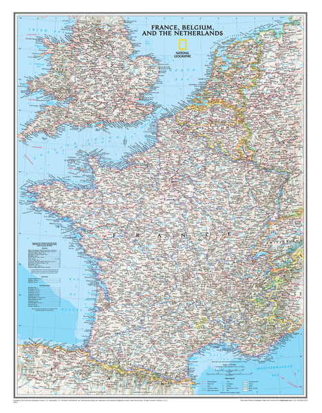
Bring the heart of Western Europe to your wall with this elegant political map of France, Belgium, and the Netherlands, designed and published by National Geographic. Featuring updated infrastructure, clear cartographic detail, and timeless design, this map is both informative and decorative—perfect for home, office, classroom, or study.
Originally published in 2016, this map captures the rich geography of the region with clearly marked international boundaries, thousands of place names, and an array of contemporary transport and industrial infrastructure.
🗺️ A Beautifully Rendered Regional Overview
Highlighted features include:
-
International borders and regional subdivisions
-
Cities, towns, and cultural landmarks
-
Major highways, roads, and rail lines
-
Airports, ferry routes, canals, and pipelines
-
National parks and protected areas
-
Oil fields and high-speed rail networks
-
Shaded relief and bathymetric ocean contours
The map also includes Luxembourg and portions of the United Kingdom, Germany, Switzerland, Spain, and Italy, offering broader European context.
Rendered in National Geographic’s signature colour palette, this map combines visual elegance with functional clarity—making it suitable for both educational and decorative purposes.
🖼️ Format Options to Suit Any Space
Choose the finish that best matches your room, purpose, or presentation style:
| Format | Description |
|---|---|
| 📜 Paper (160 gsm) | Printed on heavyweight matte-coated paper—ideal for traditional glass framing. Clean, sharp, and professional. |
| 🧼 Laminated (Encapsulated) | Fully sealed between two 80-micron gloss laminate sheets for exceptional durability. Wipeable and tear-resistant—perfect for classrooms or high-use areas. |
| 🪵 Laminated with Wooden Hang Rails | Laminated version professionally mounted with natural timber hang rails (top and bottom) and hanging cord. A practical and elegant ready-to-hang display. |
| 🖼️ Canvas (395 gsm) | Printed on HP Professional Matte Canvas using archival pigment-based inks. The result is a richly textured, fade-resistant finish with gallery-quality depth. |
| 🪵 Canvas with Wooden Hang Rails | Our premium format. Canvas mounted with lacquered timber rails and top hanging cord—timeless, tactile, and easy to install. Ideal for heritage homes, libraries, and travel spaces. |
🔨 Please allow up to 10 working days for hang-railed maps, as each piece is custom-mounted by our professional framer.
📐 Specifications
| Feature | Detail |
|---|---|
| Title | France / Belgium / Netherlands Wall Map |
| Publisher | National Geographic |
| Publication Date | 2016 |
| Scale | 1:1,955,000 |
| Dimensions | 597 mm (W) x 768 mm (H) |
| Coverage | France, Belgium, Netherlands + parts of UK, Germany, Luxembourg, Spain, Switzerland, Italy |
| Materials | 160 gsm paper / 80-micron gloss laminate / 395 gsm matte canvas |
| Printed & Mounted In | Australia |
💡 Why Choose This Map?
✔️ High-clarity cartography from the world’s most trusted map publisher
✔️ Elegant shaded relief and bathymetry add visual depth
✔️ Multiple finishing options for framing or easy hanging
✔️ Up-to-date political and infrastructure data
✔️ A perfect educational or decorative gift
✔️ Crafted and finished in Australia with care and precision
🎁 Ideal for...
-
World travellers and Europhiles
-
History and geography enthusiasts
-
Home offices, libraries, or classrooms
-
Travel agencies or boutique accommodation
-
Anyone who loves maps with style and substance
🚚 Delivery & Production Notes
-
Paper, laminated, and canvas (rolled) maps ship within 1–2 business days
-
Hang-railed maps are mounted to order – please allow up to 10 working days
-
All maps are shipped with care from Australia, in protective packaging
🌍 Add Europe’s Heartland to Your Wall Today
This beautifully detailed map of France, Belgium, and the Netherlands is more than just a reference—it’s a window into the cultural and geographic richness of Western Europe. Printed to the highest standards, it’s a map designed to last, inspire, and elevate.
👉 Order now and bring timeless European elegance to your space.


