- Australia ▾
- Topographic
▾
- Australia AUSTopo 250k (2024)
- Australia 50k Geoscience maps
- Australia 100k Geoscience maps
- Australia 250k Geoscience maps
- Australia 1.1m Geoscience maps
- New Zealand 50k maps
- New Zealand 250k maps
- New South Wales 25k maps
- New South Wales 50k maps
- New South Wales 100k maps
- Queensland 10k maps
- Queensland 25k maps
- Queensland 50k maps
- Queensland 100k maps
- Compasses
- Software
- GPS Systems
- Orienteering
- International ▾
- Wall Maps
▾
- World
- Australia & New Zealand
- Countries, Continents & Regions
- Historical
- Vintage National Geographic
- Australian Capital Territory
- New South Wales
- Northern Territory
- Queensland
- South Australia
- Tasmania
- Victoria
- Western Australia
- Celestial
- Children's
- Mining & Resources
- Wine Maps
- Healthcare
- Postcode Maps
- Electoral Maps
- Nautical ▾
- Flags
▾
- Australian Flag Sets & Banners
- Flag Bunting
- Handwavers
- Australian National Flags
- Aboriginal Flags
- Torres Strait Islander Flags
- International Flags
- Flagpoles & Accessories
- Australian Capital Territory Flags
- New South Wales Flags
- Northern Territory Flags
- Queensland Flags
- South Australia Flags
- Tasmania Flags
- Victoria Flags
- Western Australia Flags
- Gifts ▾
- Globes ▾
Dear valued customer. Please note that our checkout is not supported by old browsers. Please use a recent browser to access all checkout capabilities
Florida State Wall Map
$69.95
or make 4 interest-free payments of
$17.49 AUD
fortnightly with
![]() More info
More info
Vibrant, Accurate, and Ideal for Education, Business, and Travel Planning
Size: 1000 mm (W) × 735 mm (H)
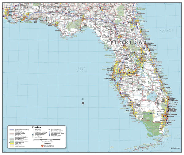
Florida — known for its sun-soaked beaches, vibrant cities, and diverse landscapes — is brought vividly to life in this meticulously detailed wall map. Whether you're mapping out a coastal road trip, studying the state’s geography, or planning logistics for business, this map delivers clarity, precision, and style in equal measure.
From the sparkling shores of Miami to the tranquil Gulf Islands, the wild beauty of the Everglades to the historic streets of St. Augustine, every corner of the Sunshine State is clearly marked and beautifully presented.
📍 Key Features at a Glance
-
Complete State Coverage – Every county in Florida is clearly outlined and named.
-
Transport & Road Networks – Displays all national and state highways, major routes, and connecting roads for easy navigation.
-
Land Use & Special Zones – Legend includes symbols for urban areas, parks, forests, military zones, waterways, and conservation areas.
-
Geographic Highlights – Pinpoints rivers, lakes, mountain ranges, and key natural features.
-
Major Cities & Towns – Easy-to-read labels for capitals, major hubs, and smaller towns.
-
Colour-Coded & Easy to Read – Attractive, vibrant colour palette for visual clarity and instant recognition.
📐 Specifications
| Feature | Details |
|---|---|
| Dimensions | 1000 mm (W) × 735 mm (H) |
| Scale | State-level detail with urban focus |
| Publication | Current edition |
| Projection | Clear and accurate cartographic projection |
| Orientation | Landscape |
| Detail Level | Cities, counties, roads, parks, water features, land use |
🖌 Premium Material & Display Options
| Format | Description |
|---|---|
| Paper (160 gsm) | Heavyweight matte-coated paper, perfect for framing under glass. |
| Laminated | Fully encapsulated in 80-micron gloss laminate — waterproof, tear-resistant, and suitable for whiteboard marker use. |
| Laminated + Hang Rails | Laminated version mounted on natural timber rails with hanging cord for instant wall display. |
| Canvas (395 gsm) | HP Professional Matte Canvas with pigment-based inks for exceptional durability and fade resistance. |
| Canvas + Hang Rails | Canvas version mounted on lacquered timber rails for a ready-to-hang, gallery-style presentation. |
Note: Please allow up to 10 working days for delivery of hang-railed maps, as each one is professionally mounted by our custom framer.
🌟 Why This Florida Map Stands Out
-
Perfect for All Uses – Suitable for schools, government offices, tourism operators, logistics companies, and home display.
-
Made to Last – Archival-quality printing and materials ensure long-term clarity and colour retention.
-
Educational Value – A visual aid for students learning about Florida’s geography, history, and environmental diversity.
-
Custom State Printing Available – We currently offer the five most visited US states, but can produce any state map on request.
🏆 Ideal For:
-
Teachers & Schools – An engaging educational tool for geography lessons.
-
Business & Corporate Use – Great for planning service areas, delivery routes, or regional projects.
-
Travel Enthusiasts – Perfect for plotting road trips and exploring Florida’s attractions.
-
Interior Décor – Adds a sophisticated and informative touch to offices, libraries, or living spaces.
This Florida State Wall Map isn’t just a reference tool — it’s a statement piece that combines function, design, and enduring quality. Whether hung in a classroom, conference room, travel agency, or living room, it’s a map you’ll return to again and again for both practical information and visual enjoyment.


