- Australia ▾
- Topographic
▾
- Australia AUSTopo 250k (2024)
- Australia 50k Geoscience maps
- Australia 100k Geoscience maps
- Australia 250k Geoscience maps
- Australia 1.1m Geoscience maps
- New Zealand 50k maps
- New Zealand 250k maps
- New South Wales 25k maps
- New South Wales 50k maps
- New South Wales 100k maps
- Queensland 10k maps
- Queensland 25k maps
- Queensland 50k maps
- Queensland 100k maps
- Compasses
- Software
- GPS Systems
- Orienteering
- International ▾
- Wall Maps
▾
- World
- Australia & New Zealand
- Countries, Continents & Regions
- Historical
- Vintage National Geographic
- Australian Capital Territory
- New South Wales
- Northern Territory
- Queensland
- South Australia
- Tasmania
- Victoria
- Western Australia
- Celestial
- Children's
- Mining & Resources
- Wine Maps
- Healthcare
- Postcode Maps
- Electoral Maps
- Nautical ▾
- Flags
▾
- Australian Flag Sets & Banners
- Flag Bunting
- Handwavers
- Australian National Flags
- Aboriginal Flags
- Torres Strait Islander Flags
- International Flags
- Flagpoles & Accessories
- Australian Capital Territory Flags
- New South Wales Flags
- Northern Territory Flags
- Queensland Flags
- South Australia Flags
- Tasmania Flags
- Victoria Flags
- Western Australia Flags
- Gifts ▾
- Globes ▾
Dear valued customer. Please note that our checkout is not supported by old browsers. Please use a recent browser to access all checkout capabilities


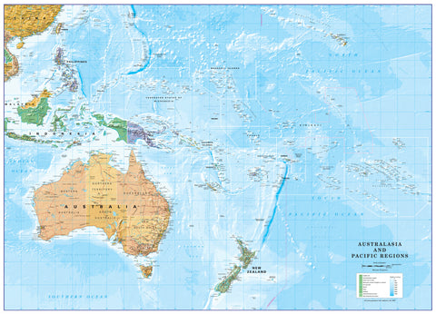
Fiji & Tonga ITMB Map
$24.95
Afterpay is only available for orders between $50.00 and $1000.00 More info
Fully Updated • Double-Sided Cartography • Optional Lamination for All-Weather Use
🌏 A Map That’s as Beautiful as the Destination
For years, International Travel Maps has been synonymous with reliable, detailed, and adventure-ready cartography. But this edition of the Fiji & Tonga Map goes beyond the ordinary. It’s the result of one of ITMB’s most extensive update projects ever—with the expertise of a local Fijian cartographer ensuring cultural accuracy, geographic precision, and insider insight.
The result is a map that doesn’t just get you from A to B—it draws you into the very heart of the South Pacific. From Fiji’s sun-drenched shores to Tonga’s tranquil lagoons, every curve of the coastline and every speck of coral reef has been rendered with care.
🏝 Double-Sided Island Coverage
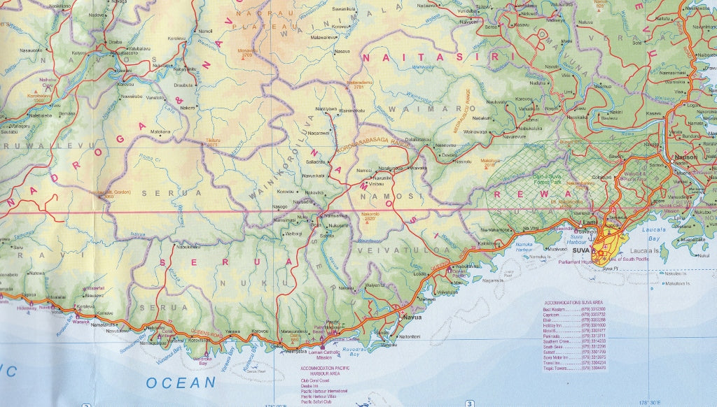
Side 1 – Fiji
-
Complete mapping of over 300 islands, from the bustling hubs of Viti Levu and Vanua Levu to remote, untouched atolls.
-
Clearly marked airports, ferry routes, and road networks for seamless island-hopping.
-
Inset Map of Suva – Fiji’s capital, featuring government buildings, cultural sites, hotels, and shopping districts.
-
Detailed topography to show mountain ranges, rivers, reefs, and marine parks.
Side 2 – Tonga
-
Full coverage of the three main island groups – Tongatapu, Ha’apai, and Vava’u – as well as outer islands.
-
Extensive marine detail for divers, sailors, and eco-travellers, including reef systems and anchorage points.
-
Inset Map of Nuku’alofa – highlighting key streets, markets, accommodation areas, and cultural attractions.
📌 Notable Features at a Glance
-
Tourist attractions – beaches, dive sites, heritage landmarks, and national parks.
-
Transport links – airports, harbours, ferry connections, and scenic drives.
-
Local facilities – hospitals, accommodation areas, marinas, and visitor centres.
-
Practical symbols for quick visual reference.
-
Balanced scale for both route planning and local navigation.
🛡 Lamination Upgrade – Built for Real-World Travel
For explorers who want their map to survive every adventure, we offer a professional lamination service:
-
80-micron full encapsulation for maximum durability.
-
Write-on/wipe-off surface – perfect for plotting routes with whiteboard markers.
-
Protection from water, humidity, sand, sunscreen, and general wear and tear.
-
Ideal for yacht decks, dive boats, beach trips, and tropical climates.
Please note: lamination is applied to a flattened folded map, so subtle fold lines will still be visible.
📐 Product Specifications
| Feature | Detail |
|---|---|
| Publisher | ITMB – International Travel Maps |
| Edition | Latest updated edition |
| Regions Covered | All islands of Fiji (with Suva inset) and Tonga (with Nuku’alofa inset) |
| Scale | Varies |
| Flat Size | 690 mm x 1000 mm |
| Folded Size | Compact for travel use |
| Material | Premium paper or laminated finish |
| ISBN | [Insert ISBN if available] |
🎯 Who This Map Is For
-
Couples & honeymooners seeking secluded beaches and luxury resorts.
-
Cruise passengers looking to explore beyond the port.
-
Scuba divers & snorkellers needing to pinpoint reefs and dive spots.
-
Sailors & yacht crews navigating between anchorages and island chains.
-
Backpackers & independent travellers planning island-hopping itineraries.
💬 Why Choose This Map?
This Fiji & Tonga ITMB Map isn’t just a navigational tool—it’s a gateway to two of the world’s most enchanting island nations. With its blend of accuracy, readability, and cultural insight, it will serve you equally well when dreaming at home, planning your trip, or navigating on the ground.
Whether you’re sailing into Vava’u’s sheltered waters, driving Fiji’s Coral Coast, or tracking down a hidden beach only the locals know, this map keeps your journey on course.