- Australia ▾
- Topographic
▾
- Australia AUSTopo 250k (2025)
- Australia 50k Geoscience maps
- Australia 100k Geoscience maps
- Australia 250k Geoscience maps
- Australia 1:1m Geoscience maps
- New Zealand 50k maps
- New Zealand 250k maps
- New South Wales 25k maps
- New South Wales 50k maps
- New South Wales 100k maps
- Queensland 10k maps
- Queensland 25k maps
- Queensland 50k maps
- Queensland 100k maps
- Western Australia 25k maps
- Western Australia 50k maps
- Western Australia 100k maps
- Compasses
- Software
- GPS Systems
- International ▾
- Wall Maps
▾
- World
- Australia & New Zealand
- Countries, Continents & Regions
- Historical
- Vintage National Geographic
- Australian Capital Territory
- New South Wales
- Northern Territory
- Queensland
- South Australia
- Tasmania
- Victoria
- Western Australia
- Celestial
- Children's
- Mining & Resources
- Wine Maps
- Healthcare
- Postcode Maps
- Electoral Maps
- Nautical ▾
- Flags
▾
- Australian Flag Sets & Banners
- Flag Bunting
- Handwavers
- Australian National Flags
- Aboriginal Flags
- Torres Strait Islander Flags
- International Flags
- Flagpoles & Accessories
- Australian Capital Territory Flags
- New South Wales Flags
- Northern Territory Flags
- Queensland Flags
- South Australia Flags
- Tasmania Flags
- Victoria Flags
- Western Australia Flags
- Gifts ▾
- Globes ▾
Dear valued customer. Please note that our checkout is not supported by old browsers. Please use a recent browser to access all checkout capabilities


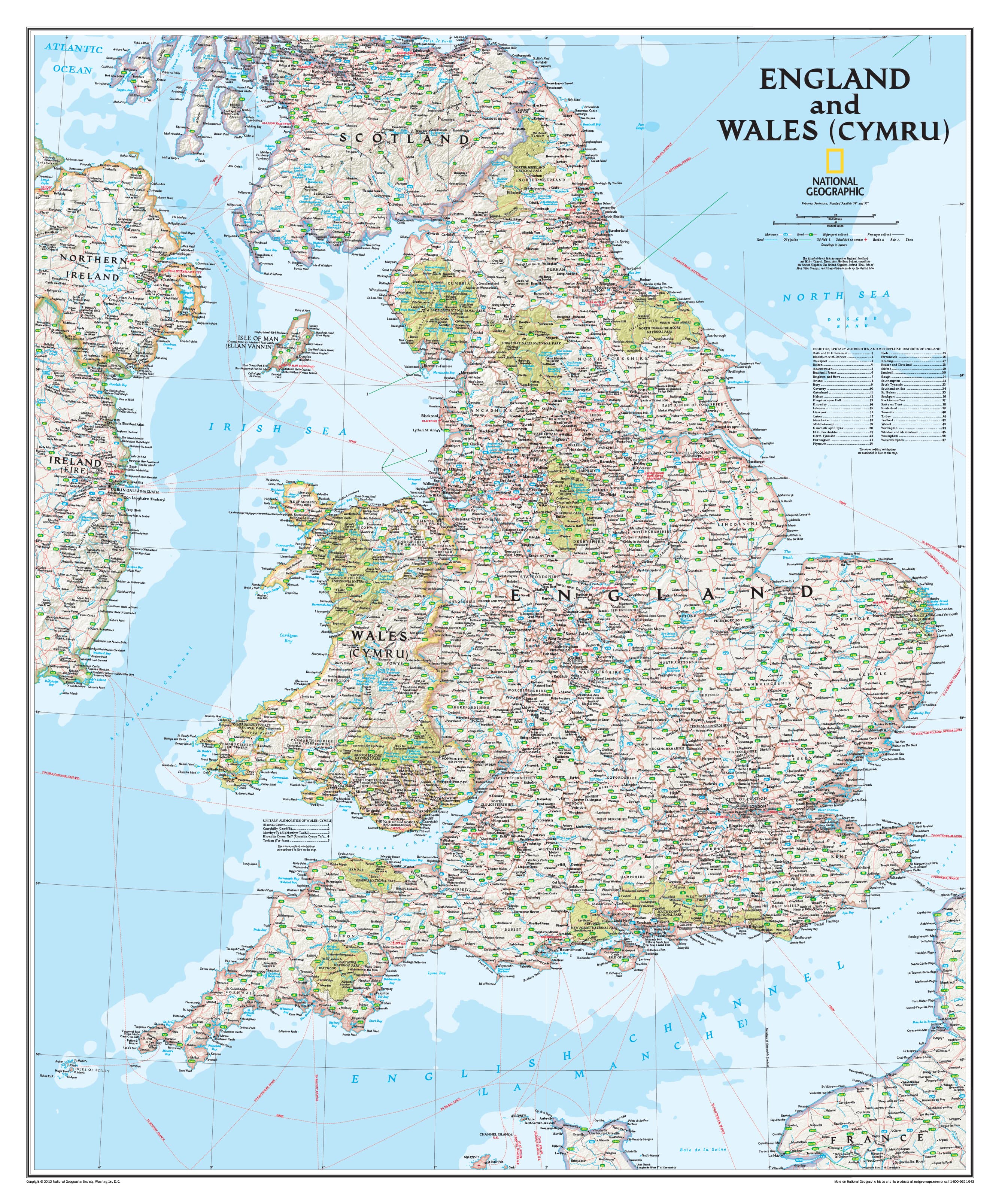
England & Wales Classic National Geographic 1200 x 1440mm Wall Map
$149.95
or make 4 interest-free payments of
$37.49 AUD
fortnightly with
![]() More info
More info
🏰 England & Wales Classic Wall Map
By National Geographic
Size: 1200 mm (W) x 1440 mm (H)
Bring the heritage, geography, and intricate human landscape of England and Wales to life with this beautifully detailed Classic Political Wall Map by National Geographic. Whether you're a passionate traveller, an educator, or a proud local, this map is more than a reference—it's a timeless celebration of the storied landscapes and urban heartlands of Britain’s most historic regions.
🗺️ A Masterclass in Cartography
Designed with the precision and elegance that have made National Geographic maps world-renowned, this large-format piece features:
-
Thousands of place names from bustling cities and quaint market towns to remote coastal villages
-
Clearly defined political boundaries for counties and unitary authorities
-
Major highways, roads, rail lines, and ferry routes
-
Airports, rivers, lakes, and estuaries
-
Beautiful shaded relief that hints at the terrain and topography of the land
This is not just a political map—it’s a journey across time and terrain, through Roman legacies, medieval strongholds, and modern metropolises. From the peaks of Snowdonia to the docks of Liverpool, from the Cotswolds to the coast of Cornwall—every corner of England and Wales is presented with clarity, beauty, and context.
🎓 Ideal For:
-
Schools and geography classrooms
-
Libraries and educational institutions
-
Office and study décor
-
British heritage enthusiasts
-
Travel planners and genealogy researchers
-
Anyone with a love of cartographic excellence
📐 Product Specifications
| Feature | Description |
|---|---|
| Dimensions | 1200 mm (W) x 1440 mm (H) |
| Publisher | National Geographic |
| Map Style | Classic Political with shaded relief |
| Coverage | All of England and Wales |
| Detail Level | Cities, towns, borders, roads, water bodies, and landmarks |
🖨️ Format & Finish Options
Choose the format that best suits your space and purpose:
📄 Paper (160 gsm)
-
Crisp, smooth finish perfect for framing under glass
-
Ideal for collectors, decorators, or those seeking a minimalist display
🧽 Laminated (Encapsulated)
-
Gloss-laminated on both sides using two layers of 80-micron film
-
Durable, waterproof, and markable with whiteboard markers
-
Great for classrooms, offices, or route-planning at home
🪵 Laminated with Timber Hang Rails
-
Ready to hang with top and bottom wooden rails in natural timber finish
-
Includes a discreet cord for instant, elegant display
-
Combines functionality and traditional charm
🖼️ Canvas (395 gsm HP Matte)
-
Printed using pigment-based inks on premium artist-grade canvas
-
Fade-resistant, beautifully textured, and exceptionally durable
-
Brings a gallery-like presence to any wall
🪵 Canvas with Timber Hang Rails
-
The ultimate statement piece
-
Canvas print mounted with hand-finished timber rails—top and bottom—with a coordinating hanging cord
-
Ideal for home libraries, studies, or stylish travel-inspired interiors
⏳ Please note: Hang-railed versions are custom-finished by our in-house framer. Kindly allow up to 10 working days for delivery.
✨ A Gift That Lasts Generations
Looking for something thoughtful and enduring? This map makes a magnificent gift for:
-
British expats and Anglophiles
-
Students and educators
-
Travel lovers and history buffs
-
Anyone starting their UK ancestry journey
-
Those seeking a distinguished, meaningful piece of décor
🏞️ Display History, Geography & Identity
Whether it’s to inspire new journeys or honour old ones, this Classic National Geographic Map of England & Wales will elevate any wall it adorns. Meticulously crafted, rich in cultural detail, and brimming with cartographic charm, it's more than just a map—it's a window into the character of two nations.
Frequently Asked Questions
What are the dimensions of the England & Wales Classic National Geographic 1200 x 1440mm Wall Map?
Mapworld wall maps range from standard 700×1000mm to large-format 1000×1430mm Supermaps. The exact dimensions for this map are shown in the product title. Where multiple sizes are available, select your preferred size when adding to cart.
Is this wall map available laminated?
Many Mapworld wall maps are available in paper, laminated, or framed finishes. Check the product options when adding to cart. Laminated maps are wipe-clean and more durable.
Is this the latest edition?
Mapworld stocks the most current editions available from all publishers. Edition year is shown in the product title where applicable. Mapworld updates its catalogue as new editions are released.
Can I write on or pin this wall map?
Laminated wall maps can be written on with whiteboard markers and wiped clean. Paper maps can be pinned on a corkboard. Choose a laminated option for a writeable surface.
Does Mapworld ship the England & Wales Classic National Geographic 1200 x 1440mm Wall Map across Australia?
Yes, Mapworld ships Australia-wide. Standard shipping is a flat $7 rate, with free standard shipping on orders over $75. Express options are available at checkout. Most orders placed before 2pm AEST on weekdays are dispatched same day.
Related Items


© 2026 Mapworld. Website designed by Genie Media
X