- Australia ▾
- Topographic
▾
- Australia AUSTopo 250k (2024)
- Australia 50k Geoscience maps
- Australia 100k Geoscience maps
- Australia 250k Geoscience maps
- Australia 1.1m Geoscience maps
- New Zealand 50k maps
- New Zealand 250k maps
- New South Wales 25k maps
- New South Wales 50k maps
- New South Wales 100k maps
- Queensland 10k maps
- Queensland 25k maps
- Queensland 50k maps
- Queensland 100k maps
- Compasses
- Software
- GPS Systems
- Orienteering
- International ▾
- Wall Maps
▾
- World
- Australia & New Zealand
- Countries, Continents & Regions
- Historical
- Vintage National Geographic
- Australian Capital Territory
- New South Wales
- Northern Territory
- Queensland
- South Australia
- Tasmania
- Victoria
- Western Australia
- Celestial
- Children's
- Mining & Resources
- Wine Maps
- Healthcare
- Postcode Maps
- Electoral Maps
- Nautical ▾
- Flags
▾
- Australian Flag Sets & Banners
- Flag Bunting
- Handwavers
- Australian National Flags
- Aboriginal Flags
- Torres Strait Islander Flags
- International Flags
- Flagpoles & Accessories
- Australian Capital Territory Flags
- New South Wales Flags
- Northern Territory Flags
- Queensland Flags
- South Australia Flags
- Tasmania Flags
- Victoria Flags
- Western Australia Flags
- Gifts ▾
- Globes ▾
Dear valued customer. Please note that our checkout is not supported by old browsers. Please use a recent browser to access all checkout capabilities


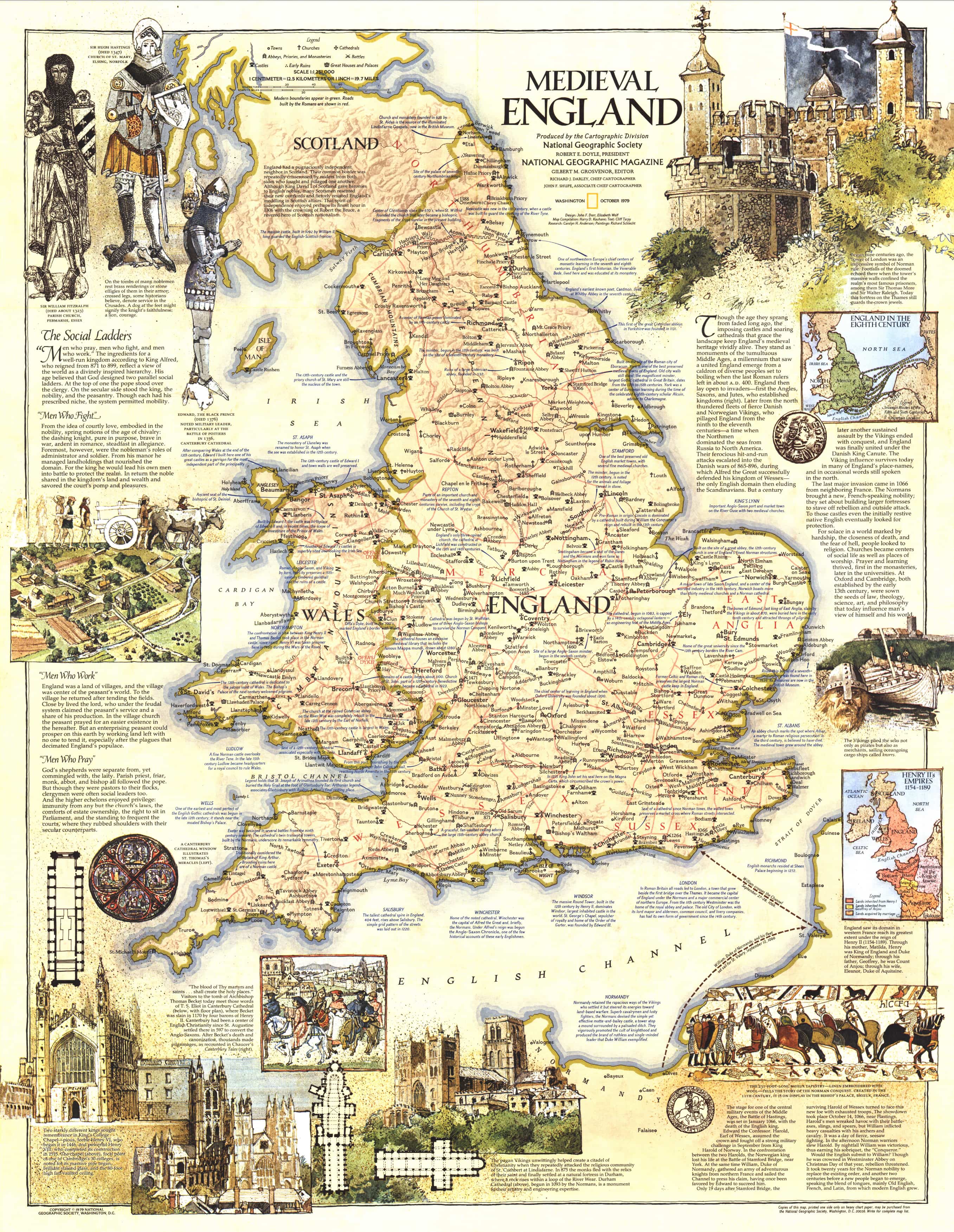
England in Medieval Times Wall Map by National Geographic
$59.95
or make 4 interest-free payments of
$14.99 AUD
fortnightly with
![]() More info
More info
🏰 England in Medieval Times – National Geographic Wall Map
Size: 575 mm (W) x 743 mm (H)
Published: October 1979 | Made in Australia
🕰️ Step Back into the Middle Ages
Take a captivating journey into the heart of medieval England with this richly illustrated historical map by National Geographic, originally published in October 1979. This exquisite wall map brings to life the castles, towns, battles, trade routes, and political boundaries that shaped England during one of its most fascinating and transformative eras.
Whether you're a student of history, a genealogist seeking ancestral insights, or simply enchanted by the drama and romance of the medieval world, this map is an evocative window into a time when knights rode into battle, cathedrals rose from stone, and the foundations of modern England were laid.
🛡️ A Treasure Trove of Medieval History
This map is not merely a decorative piece—it's a visual timeline of the Middle Ages, rich with detail and narrative. Discover:
-
⚔️ Battle sites, invasions, and shifting borders
-
🏯 Castles, abbeys, and early walled towns
-
🗺️ Historic counties and regional power centres
-
🎨 Beautiful illustrations and artistic flourishes from National Geographic’s master cartographers
-
📜 Contextual historical information that illuminates the lives and legacies of medieval England’s rulers and rebels alike
This is a map that tells a story—one that will engage viewers for hours and serve as an inspiring reference for history lovers of all ages.
🎁 A Meaningful Gift for the Historically Curious
Who would enjoy this map?
-
👑 History enthusiasts passionate about England's medieval past
-
🧬 Family historians and genealogists seeking context for ancestral research
-
📚 Students and educators exploring the evolution of British political and social life
-
🖼️ Collectors of rare and vintage-style cartography
-
🎁 Anyone looking for a unique, thoughtful gift with depth, beauty, and timeless appeal
This piece is especially powerful for those who’ve ever wondered: Where were my ancestors in the time of knights and kings?
🖨️ Premium Format Options
Available in three professionally finished formats to suit every wall, setting, and need:
| Format | Description |
|---|---|
| Paper (160 gsm) | Smooth, matte-coated heavyweight stock. Ideal for framing under glass. |
| Laminated | True 80-micron gloss encapsulation front and back—waterproof, wipeable, and long-lasting. |
| Canvas (395 gsm) | Museum-grade HP Professional Matte Canvas. Textured, fade-resistant, and printed with pigment inks. |
🪵 Optional Timber Hang Rails
For those seeking a more traditional display, we offer natural wooden hang rails for laminated and canvas maps:
-
🧵 A hanging cord is affixed to the top rail for easy wall mounting
-
🪚 Timber is lightly lacquered for a natural, elegant finish
-
🖼️ Perfect for heritage-inspired interiors or office walls with a story to tell
⏳ Please allow 10 working days for delivery of maps with hang rails, as they are custom-fitted by our framer.
📐 Specifications
| Feature | Detail |
|---|---|
| Map Title | England in Medieval Times |
| Publisher | National Geographic |
| Edition | Originally published in October 1979 |
| Content Focus | Historical map of England during the Middle Ages |
| Style | Illustrated with medieval themes and annotations |
| Size | 575 mm (W) x 743 mm (H) |
| Material Options | Paper, Laminated, Canvas |
| Optional Upgrades | Timber Hang Rails for Laminated & Canvas Versions |
| Made In | Australia |
🌟 Bring History to Your Wall
Hang this map in your study, classroom, library, or family room and be reminded every day of the rich and rugged legacy of medieval England. With its masterful design and educational depth, England in Medieval Times is more than just a map—it’s a gateway to the past.
📜 Add to cart today and bring the Middle Ages to life on your wall.


