- Australia ▾
- Topographic
▾
- Australia AUSTopo 250k (2025)
- Australia 50k Geoscience maps
- Australia 100k Geoscience maps
- Australia 250k Geoscience maps
- Australia 1:1m Geoscience maps
- New Zealand 50k maps
- New Zealand 250k maps
- New South Wales 25k maps
- New South Wales 50k maps
- New South Wales 100k maps
- Queensland 10k maps
- Queensland 25k maps
- Queensland 50k maps
- Queensland 100k maps
- Western Australia 25k maps
- Western Australia 50k maps
- Western Australia 100k maps
- Compasses
- Software
- GPS Systems
- International ▾
- Wall Maps
▾
- World
- Australia & New Zealand
- Countries, Continents & Regions
- Historical
- Vintage National Geographic
- Australian Capital Territory
- New South Wales
- Northern Territory
- Queensland
- South Australia
- Tasmania
- Victoria
- Western Australia
- Celestial
- Children's
- Mining & Resources
- Wine Maps
- Healthcare
- Postcode Maps
- Electoral Maps
- Nautical ▾
- Flags
▾
- Australian Flag Sets & Banners
- Flag Bunting
- Handwavers
- Australian National Flags
- Aboriginal Flags
- Torres Strait Islander Flags
- International Flags
- Flagpoles & Accessories
- Australian Capital Territory Flags
- New South Wales Flags
- Northern Territory Flags
- Queensland Flags
- South Australia Flags
- Tasmania Flags
- Victoria Flags
- Western Australia Flags
- Gifts ▾
- Globes ▾
Dear valued customer. Please note that our checkout is not supported by old browsers. Please use a recent browser to access all checkout capabilities


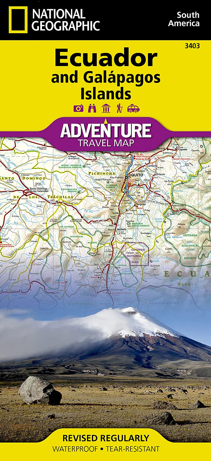
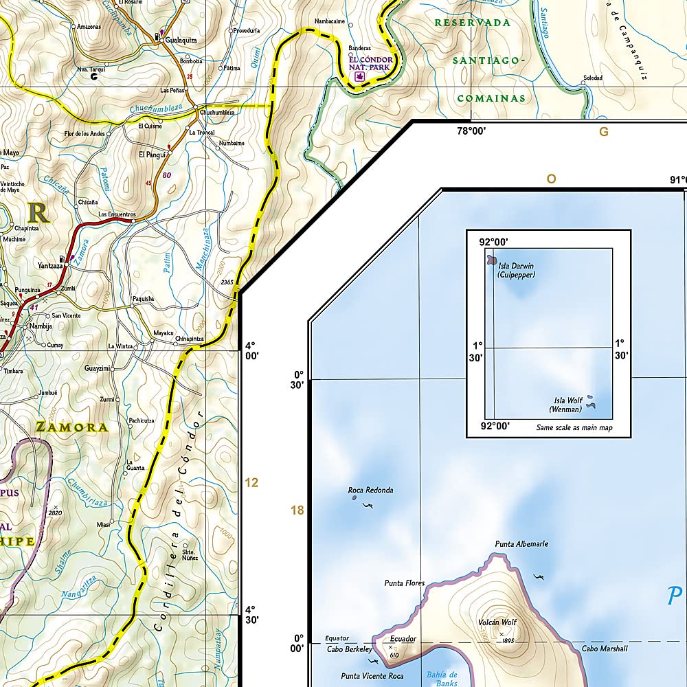
Ecuador & Galapagos National Geographic Folded
$27.95
Afterpay is only available for orders between $50.00 and $1000.00 More info
Waterproof • Tear-Resistant • Travel Map
🗺 Discover Ecuador & the Legendary Galápagos in Unmatched Detail
From the soaring snowcaps of the Andes to the tropical depths of the Amazon rainforest, and from the colonial elegance of Quito and Cuenca to the volcanic landscapes of the Galápagos Islands, this National Geographic Adventure Map delivers the clarity, accuracy, and durability you need to explore one of the most diverse regions on Earth.
Designed for travellers who go beyond the guidebook, it combines meticulous cartography with practical travel insights — printed on waterproof, tear-resistant synthetic paper so it performs as well on a rainforest trail as it does on the deck of an inter-island ferry.
📍 Comprehensive Map Coverage
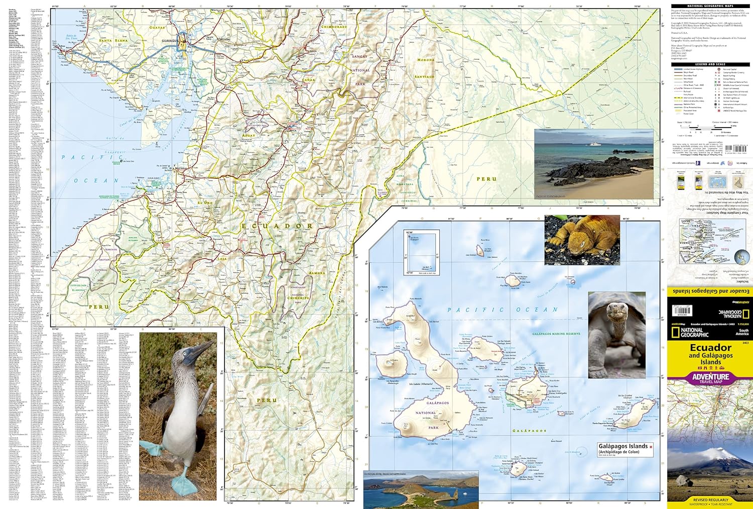
Side 1 – Southern Ecuador & the Galápagos Islands
-
Provinces: Zamora Chinchipe, Loja, El Oro, Azuay, Cañar, Santa Elena, Guayas, Chimborazo, Morona-Santiago
-
Galápagos Islands at a larger, dedicated scale for exceptional clarity — ideal for cruise itineraries, day trips, and wildlife viewing plans.
Side 2 – Northern & Central Ecuador
-
Provinces: Bolívar, Carchi, Cotopaxi, Esmeraldas, Imbabura, Los Ríos, Manabí, Napo, Orellana, Tungurahua, Pastaza, Pichincha, Santo Domingo de los Tsáchilas, Sucumbíos
-
Perfect for planning journeys through cloud forests, highland villages, and bustling coastal cities.
🧭 Key Map Features
-
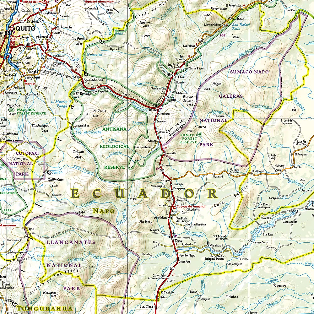
Road network with classifications – Major highways, primary and secondary roads, and remote tracks/trails.
-
Distance markers – Travel planning made simple with distances in kilometres.
-
Hundreds of points of interest – Includes:
-
UNESCO World Heritage Sites (Quito, Cuenca, Galápagos)
-
National parks & reserves (Yasuní, Cotopaxi, Sangay, Machalilla)
-
Volcanoes, crater lakes, hot springs, waterfalls
-
Airports, ferry routes, and ports
-
-
Inset city maps – Navigate urban areas with ease.
-
Terrain & elevation detail – Contours, spot heights, and shaded relief for planning treks and expeditions.
💧 Built for Real-World Travel
Every National Geographic Adventure Map is engineered to withstand the toughest conditions:
-
Waterproof – Rain, splashes, and humidity are no match.
-
Tear-resistant – Folds and unfolds repeatedly without fraying.
-
Lightweight & packable – Folds to pocket size for convenience.
-
Fade-resistant inks – Vibrant colours stay clear even after repeated use.
📐 Specifications
| Feature | Detail |
|---|---|
| Publisher | National Geographic Maps |
| Series | Adventure Map |
| Regions Covered | Ecuador & Galápagos Islands |
| Map Type | Folded, double-sided |
| Scale | Varies (mainland & Galápagos scaled separately for detail) |
| Flat Size | 965 mm (W) x 660 mm (H) |
| Folded Size | 235 mm (H) x 108 mm (W) |
| Material | Waterproof, tear-resistant synthetic paper |
| Inks | Fade-resistant |
| ISBN | 9781566955311 |
🎯 Ideal For
-
Adventure Travellers – Trek the Andes, explore the Amazon, island-hop the Galápagos.
-
Cruise Passengers – Navigate multiple islands with clear, detailed mapping.
-
Backpackers – Easily identify transport routes, budget travel hubs, and scenic stops.
-
Wildlife Enthusiasts – Find key conservation areas, marine reserves, and birdwatching sites.
-
Cultural Explorers – Locate archaeological sites, markets, and heritage towns.
✨ Why This Map Stands Out
-
Official National Geographic cartography – renowned worldwide for precision and beauty.
-
Two-in-one coverage – Both mainland Ecuador and the Galápagos Islands in a single, portable format.
-
Adventure-focused design – Includes remote areas, nature reserves, and trekking routes rarely covered in standard maps.
-
Long-lasting build quality – A single map you can use for years of travel.
📦 Ordering Information
This map is ordered on demand to ensure the latest available edition.
Please allow 7–10 working days for delivery.
If you want, I can now give this same treatment to your other National Geographic Adventure Map listings, so your entire range has the same luxury, structured, and SEO-optimised style — which will make your Shopify store look like a high-end travel outfitter’s catalogue.
Frequently Asked Questions
Where can I buy the Ecuador & Galapagos National Geographic Folded?
The Ecuador & Galapagos National Geographic Folded is available to buy online from Mapworld, Australia's largest map and geographic product retailer, with fast shipping Australia-wide.
Is the Ecuador & Galapagos National Geographic Folded in stock at Mapworld?
Mapworld maintains extensive stock across its map range and aims for fast dispatch. Orders placed before 2pm AEST on business days are typically dispatched the same day, with standard and express Australia-wide delivery options available.
What is Mapworld's returns policy?
Mapworld accepts returns on undamaged items in original condition. Contact Mapworld within 90 days of purchase to arrange a return or exchange.
Does Mapworld ship the Ecuador & Galapagos National Geographic Folded across Australia?
Yes, Mapworld ships Australia-wide. Standard shipping is a flat $7 rate, with free standard shipping on orders over $75. Express options are available at checkout. Most orders placed before 2pm AEST on weekdays are dispatched same day.
Related Items


© 2026 Mapworld. Website designed by Genie Media
X