- Australia ▾
- Topographic
▾
- Australia AUSTopo 250k (2025)
- Australia 50k Geoscience maps
- Australia 100k Geoscience maps
- Australia 250k Geoscience maps
- Australia 1:1m Geoscience maps
- New Zealand 50k maps
- New Zealand 250k maps
- New South Wales 25k maps
- New South Wales 50k maps
- New South Wales 100k maps
- Queensland 10k maps
- Queensland 25k maps
- Queensland 50k maps
- Queensland 100k maps
- Compasses
- Software
- GPS Systems
- Orienteering
- International ▾
- Wall Maps
▾
- World
- Australia & New Zealand
- Countries, Continents & Regions
- Historical
- Vintage National Geographic
- Australian Capital Territory
- New South Wales
- Northern Territory
- Queensland
- South Australia
- Tasmania
- Victoria
- Western Australia
- Celestial
- Children's
- Mining & Resources
- Wine Maps
- Healthcare
- Postcode Maps
- Electoral Maps
- Nautical ▾
- Flags
▾
- Australian Flag Sets & Banners
- Flag Bunting
- Handwavers
- Australian National Flags
- Aboriginal Flags
- Torres Strait Islander Flags
- International Flags
- Flagpoles & Accessories
- Australian Capital Territory Flags
- New South Wales Flags
- Northern Territory Flags
- Queensland Flags
- South Australia Flags
- Tasmania Flags
- Victoria Flags
- Western Australia Flags
- Gifts ▾
- Globes ▾
Dear valued customer. Please note that our checkout is not supported by old browsers. Please use a recent browser to access all checkout capabilities


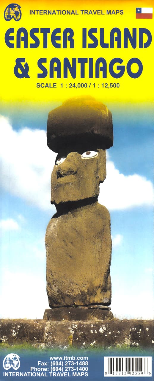
Easter Island & Santiago ITMB Map
$24.95
Afterpay is only available for orders between $50.00 and $1000.00 More info
Double-Sided Map | Detailed Site Locations | Adventure Ready
Scale: 1:24,000 (Easter Island) / 1:12,500 (Santiago)
Flat Size: 690 mm x 1000 mm (27" x 39")
Publisher: ITMB (International Travel Maps)
Step into one of the world’s most remote and enigmatic destinations with this beautifully detailed Easter Island & Santiago travel map by ITMB. From the windswept plains of Rapa Nui to the bustling heart of Chile’s capital, this double-sided map combines archaeological intrigue with practical travel guidance—perfect for explorers, culture seekers, and independent travellers.
Whether you're navigating the coastal roads of Easter Island in search of moai statues, or discovering museums and historic sites in Santiago, this map is your indispensable tool for planning and discovery.
🧭 Map Coverage
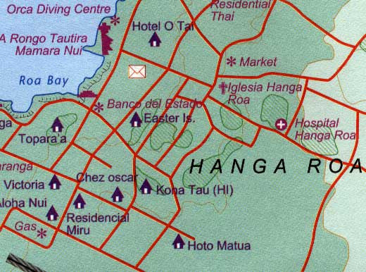
🗿 Side 1: Easter Island (Isla de Pascua / Rapa Nui) – Scale 1:24,000
-
Shows the full island in rich detail, including:
-
🗿 Moai statues: Dozens of named sites, some with visible ahu platforms and capstones
-
🏡 Hanga Roa, the island’s only town, including:
-
Accommodation options
-
Restaurants and local services
-
Cultural attractions and museums
-
-
🛣️ Roads, walking trails, and topographic features
-
🏖️ Beaches, volcanic craters, caves, and sacred ceremonial grounds
-
🏙️ Side 2: Santiago de Chile – Scale 1:12,500
-
Detailed street map of central Santiago, including:
-
📍 Points of interest: museums, plazas, monuments, and government buildings
-
🚇 Metro stations and public transport
-
🏛️ Historic sites and cultural venues
-
🛍️ Shopping districts, markets, and main roads
-
🌟 Key Features
-
🗺️ Accurate, up-to-date cartography for both urban and remote settings
-
🧭 Tourist highlights clearly marked, including archaeological, natural, and cultural points of interest
-
🌄 Topographic relief for elevation, crater locations, and natural features on Easter Island
-
🏨 Hotels and services mapped for Hanga Roa and central Santiago
-
✈️ Includes orientation tools for visitors arriving by air or sea
🧾 Map Specifications
| Feature | Details |
|---|---|
| Publisher | ITMB (International Travel Maps) |
| Map Type | Double-sided folded travel map |
| Scales | 1:24,000 (Easter Island) / 1:12,500 (Santiago) |
| Size (Flat) | 690 mm x 1000 mm (27" x 39") |
| Format | Folded (Optional lamination available) |
| Language | English |
| Edition | Latest available |
🛡️ Optional Lamination Available
For enhanced durability and usability, we offer a laminated version of this map:
-
💧 Waterproof and tear-resistant
-
✏️ Write-on/wipe-off surface – ideal for planning with whiteboard markers or map dots
-
🔒 Laminated using 80-micron encapsulation
-
📦 Map is flattened before lamination – note: slight fold lines may still be visible
Perfect for fieldwork, educational use, or wall display.
🧳 Who Is This Map For?
Ideal for:
-
🗿 Cultural travellers and archaeologists visiting Easter Island
-
✈️ Adventure tourists combining remote island travel with urban exploration in Santiago
-
📸 Backpackers and photographers seeking hidden moai or vibrant Chilean street scenes
-
🧭 Travel planners and educators studying Pacific island culture or South American capitals
-
🗺️ Map collectors looking for rare, niche destinations
🌍 Why Choose This Map?
Easter Island is one of the most isolated inhabited places on Earth, and this is one of the few printed maps that covers it in rich detail. With archaeological markers, cultural icons, and accurate road information, this map helps you uncover the secrets of the ancient Rapa Nui civilization. Paired with a clear and navigable map of Santiago, this dual-purpose map is perfect for planning your journey from the Andes to the Pacific.
Frequently Asked Questions
Where can I buy the Easter Island & Santiago ITMB Map?
The Easter Island & Santiago ITMB Map is available to buy online from Mapworld, Australia's largest map and geographic product retailer, with fast shipping Australia-wide.
Is the Easter Island & Santiago ITMB Map in stock at Mapworld?
Mapworld maintains extensive stock across its map range and aims for fast dispatch. Orders placed before 2pm AEST on business days are typically dispatched the same day, with standard and express Australia-wide delivery options available.
What is Mapworld's returns policy?
Mapworld accepts returns on undamaged items in original condition. Contact Mapworld within 90 days of purchase to arrange a return or exchange.
Does Mapworld ship the Easter Island & Santiago ITMB Map across Australia?
Yes, Mapworld ships Australia-wide. Standard shipping is a flat $7 rate, with free standard shipping on orders over $75. Express options are available at checkout. Most orders placed before 2pm AEST on weekdays are dispatched same day.
Related Items


© 2026 Mapworld. Website designed by Genie Media
X