- Australia ▾
- Topographic
▾
- Australia AUSTopo 250k (2025)
- Australia 50k Geoscience maps
- Australia 100k Geoscience maps
- Australia 250k Geoscience maps
- Australia 1:1m Geoscience maps
- New Zealand 50k maps
- New Zealand 250k maps
- New South Wales 25k maps
- New South Wales 50k maps
- New South Wales 100k maps
- Queensland 10k maps
- Queensland 25k maps
- Queensland 50k maps
- Queensland 100k maps
- Western Australia 25k maps
- Western Australia 50k maps
- Western Australia 100k maps
- Compasses
- Software
- GPS Systems
- International ▾
- Wall Maps
▾
- World
- Australia & New Zealand
- Countries, Continents & Regions
- Historical
- Vintage National Geographic
- Australian Capital Territory
- New South Wales
- Northern Territory
- Queensland
- South Australia
- Tasmania
- Victoria
- Western Australia
- Celestial
- Children's
- Mining & Resources
- Wine Maps
- Healthcare
- Postcode Maps
- Electoral Maps
- Nautical ▾
- Flags
▾
- Australian Flag Sets & Banners
- Flag Bunting
- Handwavers
- Australian National Flags
- Aboriginal Flags
- Torres Strait Islander Flags
- International Flags
- Flagpoles & Accessories
- Australian Capital Territory Flags
- New South Wales Flags
- Northern Territory Flags
- Queensland Flags
- South Australia Flags
- Tasmania Flags
- Victoria Flags
- Western Australia Flags
- Gifts ▾
- Globes ▾
Dear valued customer. Please note that our checkout is not supported by old browsers. Please use a recent browser to access all checkout capabilities


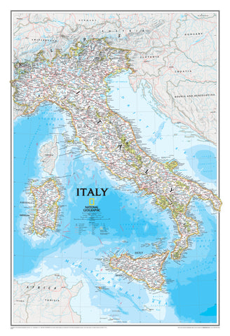
Dolomites & NE Italy ITMB Map
$24.95
Afterpay is only available for orders between $50.00 and $1000.00 More info
🇮🇹 Dolomites & Northeastern Italy Travel Map – ITMB
Double-Sided Map | Detailed & Regional Coverage
Scales: 1:40,000 (Dolomites) / 1:450,000 (Northeastern Italy)
Flat Size: 690 mm x 990 mm (27" x 39")
Publisher: ITMB (International Travel Maps)
Edition: Latest Available
Discover the dramatic alpine landscapes and cultural richness of Northern Italy with this double-sided travel map from ITMB, covering the Dolomites and the broader Northeast region of Italy. From winding mountain trails to charming historic towns and cultural landmarks, this newly developed map combines precision, topographic detail, and curated travel insight to help you make the most of your Italian adventure.
Perfect for hikers, cyclists, road trippers, or anyone exploring the Italian Alps and beyond—from the jagged peaks of South Tyrol to the vineyards of Veneto.
🗺️ Double-Sided Map Coverage
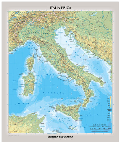
🏞️ Side 1: Dolomites Detail Map (Scale: 1:40,000)
-
Covers from Trento in the south to Sterzing-Vipiteno near the Austrian border
-
Includes:
-
🚶♂️ Footpaths and hiking trails
-
🏰 Castles, fortresses, and historical landmarks
-
🏨 Hotels and accommodations
-
🖼️ Museums and cultural sites
-
-
Ideal for walkers, cyclists, and alpine explorers
-
Includes a Top Attractions List for easy reference
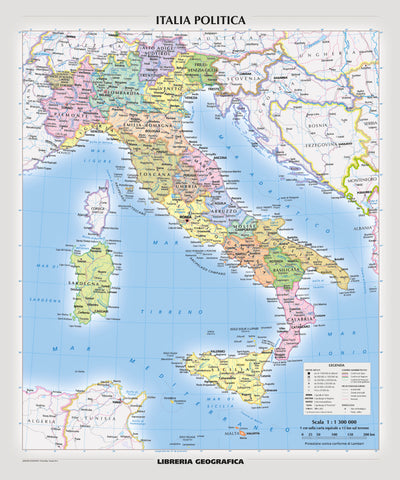
🗺️ Side 2: Northeastern Italy Regional Map (Scale: 1:450,000)
-
Covers a broader area from the Slovenian border west to Brescia, and from the Swiss border south to Siena
-
A regional overview perfect for longer-distance planning
-
Includes major cities such as:
-
Venice, Trieste, Verona, Padua, Udine, and Bologna
-
-
Also includes its own Top Attractions List and an inset showing the location of the detailed Dolomites map
🌟 Key Features
-
🗺️ Accurate road and rail networks for regional and local travel
-
🧭 Topographic shading and relief to reflect terrain, elevation, and mountain contours
-
🏞️ Natural features and national parks marked clearly
-
🏰 Tourist points of interest: castles, UNESCO sites, museums, scenic drives, and viewpoints
-
📍 Perfect balance of detail and usability for both planning and navigation
🧾 Map Specifications
| Feature | Details |
|---|---|
| Publisher | ITMB (International Travel Maps) |
| Map Type | Double-sided folded travel map |
| Scales | 1:40,000 (Dolomites) / 1:450,000 (NE Italy) |
| Size (Flat) | 690 mm x 990 mm (27" x 39") |
| Format | Folded (Optional lamination available) |
| Language | English |
| Edition | Most recent available |
🛡️ Optional Lamination Available
For long-lasting durability and enhanced usability, we offer a professionally laminated version of this map:
-
💧 Waterproof and tear-resistant
-
✏️ Write-on/wipe-off surface – perfect for marking routes or applying removable map dots
-
🔒 Encapsulated in high-quality 80-micron laminate
-
📦 Flattened before laminating – slight fold lines may still be visible
Ideal for wall display, trip planning, or use in wet or rugged conditions.
🧳 Who Is This Map For?
Ideal for:
-
🥾 Hikers and mountain trekkers exploring the Dolomites
-
🚗 Road trippers and cyclists navigating alpine passes and scenic drives
-
🏞️ Nature and heritage travellers seeking castles, national parks, and historic towns
-
🗺️ Travel planners, educators, and students of Italian geography
-
✈️ Independent travellers wanting to go beyond Venice and Rome
🇮🇹 Why Choose This Map?
This Dolomites & Northeastern Italy ITMB map offers a unique and practical combination of hyper-detailed alpine mapping and regional planning tools in a single publication. It's ideal for travellers who want to hike the trails of South Tyrol in the morning and drive to the canals of Venice by evening.
Covering one of Italy's most spectacular yet often underappreciated regions, this map helps you discover not only the iconic but the truly memorable.
Frequently Asked Questions
Where can I buy the Dolomites & NE Italy ITMB Map?
The Dolomites & NE Italy ITMB Map is available to buy online from Mapworld, Australia's largest map and geographic product retailer, with fast shipping Australia-wide.
Is the Dolomites & NE Italy ITMB Map in stock at Mapworld?
Mapworld maintains extensive stock across its map range and aims for fast dispatch. Orders placed before 2pm AEST on business days are typically dispatched the same day, with standard and express Australia-wide delivery options available.
What is Mapworld's returns policy?
Mapworld accepts returns on undamaged items in original condition. Contact Mapworld within 90 days of purchase to arrange a return or exchange.
Does Mapworld ship the Dolomites & NE Italy ITMB Map across Australia?
Yes, Mapworld ships Australia-wide. Standard shipping is a flat $7 rate, with free standard shipping on orders over $75. Express options are available at checkout. Most orders placed before 2pm AEST on weekdays are dispatched same day.
Related Items
© 2026 Mapworld. Website designed by Genie Media
X