Large-Format | Political Boundaries | Premium Finishes
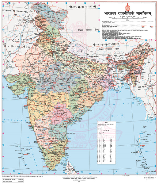
Discover India’s political landscape through the lens of classical language with the India Political Wall Map (Sanskrit Edition)—a refined blend of authoritative cartography, cultural depth, and display-ready design. Built on Survey of India mapping, this edition presents national and state boundaries, state/UT differentiation by colour, and an intuitive overlay of principal railways and major roads—all labelled in Sanskrit for a uniquely scholarly and striking presentation. Perfect for classrooms, offices, libraries, and home studies.
🗺️ Map Features
Full Political Coverage – Clear national and state/UT boundaries, with each state distinguished by a clean, readable colour palette.
Administrative & Urban Detail – State and union territory names, capitals, and key cities displayed with a thoughtful label hierarchy.
Transport Overlay – Principal railways and major road corridors shown for instant context and connectivity.
Sanskrit Toponymy – All place names and labels are presented in Sanskrit (Devanāgarī), offering cultural and linguistic depth without sacrificing clarity.
Wall-Optimized Design – Balanced cartography, disciplined typography, and a tidy legend ensure excellent legibility at viewing distance.
✨ Available Finishes
Choose the perfect format to bring the Sanskrit Edition to life in your space:
| Format | Description |
|---|---|
| 🖨️ Paper (160 gsm) | Heavyweight matte-coated paper—perfect for framing under glass. |
| 🧼 Laminated (Encapsulated) | Fully sealed between two sheets of 80-micron gloss laminate. Durable, wipe-clean, and ideal for frequent use. |
| 🪵 Laminated with Wooden Hang Rails | Laminated map mounted with lacquered natural timber rails (top & bottom) and a sturdy hanging cord—ready to hang. |
| 🖼️ Canvas (395 gsm) | Printed on HP Professional Matte Canvas using archival pigment-based inks. Rich texture, fade-resistant, and gallery-quality. |
| 🪵 Canvas with Wooden Hang Rails | Canvas mounted with lacquered timber rails and a hanging cord for a timeless, ready-to-display finish. |
🔨 Please allow up to 10 working days for delivery of hang-railed maps, as each one is professionally mounted by our custom framer.
📐 Specifications
| Feature | Detail |
|---|---|
| Title | India Political Wall Map (Sanskrit Edition) |
| Scale | 1:3,500,000 |
| Dimensions | 900 mm (w) × 760 mm (h) |
| Materials | Paper, Laminated, Canvas, Hang-Railed |
| Printing | Pigment-based inks, fade-resistant |
| Cartography | Survey of India (National Mapping Agency) |
| Language | Sanskrit (Devanāgarī) |
| Made in | Australia |
💡 Why You’ll Love This Map
✔️ Sanskrit labels for a culturally rich, academic presentation
✔️ Clear political structure with state/UT boundaries at a glance
✔️ Transport context via principal railways and major roads
✔️ Wall-ready design—high contrast, crisp type, superb legibility
✔️ Five premium finishes to suit classrooms, offices, and elegant interiors
🎁 Perfect for Learning & Inspiration
Ideal for educators, students of Indology and linguistics, policy and planning teams, and map lovers seeking a distinctive, language-forward view of India’s political geography.
🚚 Delivery
Flat and rolled maps (paper, laminated, canvas) typically ship within 1–2 business days.
Hang-railed maps are made to order and ship within 10 working days.
Securely packaged to arrive in perfect condition.
Bring India’s political landscape—in Sanskrit—to life on your wall.
👉 Order now for a premium map that informs, inspires, and elevates your space.


