- Australia ▾
- Topographic
▾
- Australia AUSTopo 250k (2025)
- Australia 50k Geoscience maps
- Australia 100k Geoscience maps
- Australia 250k Geoscience maps
- Australia 1:1m Geoscience maps
- New Zealand 50k maps
- New Zealand 250k maps
- New South Wales 25k maps
- New South Wales 50k maps
- New South Wales 100k maps
- Queensland 10k maps
- Queensland 25k maps
- Queensland 50k maps
- Queensland 100k maps
- Compasses
- Software
- GPS Systems
- Orienteering
- International ▾
- Wall Maps
▾
- World
- Australia & New Zealand
- Countries, Continents & Regions
- Historical
- Vintage National Geographic
- Australian Capital Territory
- New South Wales
- Northern Territory
- Queensland
- South Australia
- Tasmania
- Victoria
- Western Australia
- Celestial
- Children's
- Mining & Resources
- Wine Maps
- Healthcare
- Postcode Maps
- Electoral Maps
- Nautical ▾
- Flags
▾
- Australian Flag Sets & Banners
- Flag Bunting
- Handwavers
- Australian National Flags
- Aboriginal Flags
- Torres Strait Islander Flags
- International Flags
- Flagpoles & Accessories
- Australian Capital Territory Flags
- New South Wales Flags
- Northern Territory Flags
- Queensland Flags
- South Australia Flags
- Tasmania Flags
- Victoria Flags
- Western Australia Flags
- Gifts ▾
- Globes ▾
Dear valued customer. Please note that our checkout is not supported by old browsers. Please use a recent browser to access all checkout capabilities
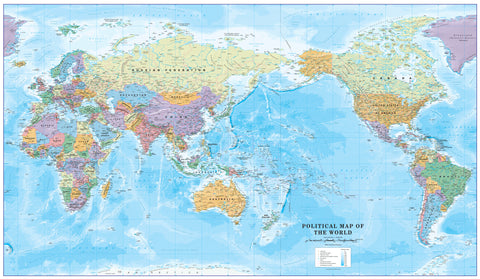
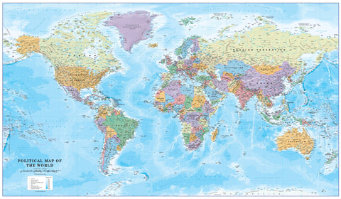
Children's Political World Supermap for the Colour Blind 1355 x 790 mm
$79.95
or make 4 interest-free payments of
$19.99 AUD
fortnightly with
![]() More info
More info
🌍 Children’s Political World Supermap for the Colour-Blind — 1355 × 790 mm
A world every child can see—clearly.
This large-format, accessibility-first political world map is designed so learners with any common form of colour blindness can confidently tell countries apart and spot capital cities at a glance. It’s a joyful, inclusive resource for classrooms, libraries, training rooms, and family learning spaces.
🇦🇺 In Australia, about 8% of males and 0.4% of females experience colour blindness. This Supermap helps bring everyone into the picture.
✨ Highlights at a Glance
-
♿️ Accessibility-first palette — Works with deuteranopia, protanopia & tritanopia
-
🧒 Kid-friendly clarity — Clear label hierarchy for countries & capitals
-
🖍️ Interactive option — Write-on/wipe-off lamination for lessons and quizzes
-
🖼️ Display your way — Frame-ready paper, sleek hang rails, or gallery-worthy canvas
-
🇦🇺 Made in Australia — Premium materials, printed for longevity and colour fidelity
🧭 Choose Your Finish
| ✅ Finish | Best For | Durability | Write-On | Display Style | Look & Feel |
|---|---|---|---|---|---|
| Paper (160 gsm heavyweight) | Framing under glass; protected spaces | ★★☆ | Frame it your way | Smooth premium stock; crisp, sharp detail | |
| Laminated (80-micron gloss, true encapsulation) | Daily classroom use; training rooms | ★★★ | ✅ | Pins, rails, or hooks | Fully sealed edge-to-edge; wipe clean |
| Laminated + Hang Rails | Instant professional display | ★★★ | ✅ | Natural timber hang rails + cord | Ready-to-hang; durable and smart |
| Canvas (395 gsm HP Professional Matte) | Decor statement; long-term display | ★★★ | Hooks or rails | Rich texture; pigment inks resist fading | |
| Canvas + Hang Rails | Easiest elegant display | ★★★ | Natural timber hang rails + cord | Gallery look with warm timber finish |
🪵 Lead Time: Hang-railed versions are professionally mounted. Please allow up to 10 working days for delivery.
♿️ Accessibility by Design
| Colour-Vision Challenge | Typical Confusion | How This Map Helps |
|---|---|---|
| Deuteranopia / Protanopia | Red–green hues | Carefully separated, non-confusable colour families |
| Tritanopia | Blue–yellow hues | Distinct alternatives with strong boundary contrast |
| Low Contrast | Faint outlines & labels | Bold boundary lines and legible, kid-friendly typography |
🗺️ What’s on the Map
-
All countries with high-contrast political boundaries
-
National capitals clearly labelled
-
Major oceans & seas for global orientation
-
Balanced, accessibility-tuned colour palette for fast differentiation
📐 Specifications
| Attribute | Detail |
|---|---|
| Title | Children’s Political World Supermap for the Colour-Blind |
| Size | 1355 mm (W) × 790 mm (H) |
| Scale | 1:30,000,000 |
| Edition | Published 2019 |
| Paper | 160 gsm heavyweight |
| Lamination | True encapsulation with 80-micron gloss film (front & back) |
| Canvas | 395 gsm HP Professional Matte Canvas, pigment-based inks |
| Hang Rails | Lacquered natural timber; top rail with hanging cord |
| Origin | Made in Australia |
🧼 Care & Display
| Finish | Care | Pro Tip |
|---|---|---|
| Paper | Frame under glass; keep dry | Choose UV-protective glazing for sunlit rooms |
| Laminated | Wipe with a soft dry or slightly damp cloth | Use non-abrasive dry-erase markers |
| Canvas | Dust lightly with a soft brush | Avoid prolonged direct sunlight for best longevity |
| Hang Rails | Hang from a sturdy hook | Use a spirit level for a perfectly straight finish |
🎯 Perfect For
-
Primary & secondary classrooms focused on inclusive learning
-
Learning support & SEN programs where clarity builds confidence
-
Homeschooling families inspiring global curiosity
-
Training rooms & offices that value accessibility and great design
🛒 How to Order
-
Select your finish — Paper, Laminated, Laminated with Hang Rails, Canvas, or Canvas with Hang Rails.
-
Add to cart and choose your shipping method.
-
Enjoy an inclusive, confidence-building world map that looks fantastic and lasts.
Bring the whole world into view—beautifully, accessibly, and at Supermap scale.


