- Australia ▾
- Topographic
▾
- Australia AUSTopo 250k (2024)
- Australia 50k Geoscience maps
- Australia 100k Geoscience maps
- Australia 250k Geoscience maps
- Australia 1.1m Geoscience maps
- New Zealand 50k maps
- New Zealand 250k maps
- New South Wales 25k maps
- New South Wales 50k maps
- New South Wales 100k maps
- Queensland 10k maps
- Queensland 25k maps
- Queensland 50k maps
- Queensland 100k maps
- Compasses
- Software
- GPS Systems
- Orienteering
- International ▾
- Wall Maps
▾
- World
- Australia & New Zealand
- Countries, Continents & Regions
- Historical
- Vintage National Geographic
- Australian Capital Territory
- New South Wales
- Northern Territory
- Queensland
- South Australia
- Tasmania
- Victoria
- Western Australia
- Celestial
- Children's
- Mining & Resources
- Wine Maps
- Healthcare
- Postcode Maps
- Electoral Maps
- Nautical ▾
- Flags
▾
- Australian Flag Sets & Banners
- Flag Bunting
- Handwavers
- Australian National Flags
- Aboriginal Flags
- Torres Strait Islander Flags
- International Flags
- Flagpoles & Accessories
- Australian Capital Territory Flags
- New South Wales Flags
- Northern Territory Flags
- Queensland Flags
- South Australia Flags
- Tasmania Flags
- Victoria Flags
- Western Australia Flags
- Gifts ▾
- Globes ▾
Dear valued customer. Please note that our checkout is not supported by old browsers. Please use a recent browser to access all checkout capabilities


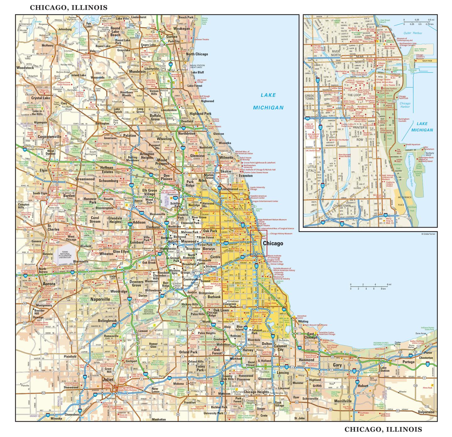
Chicago Wall Map
$69.95
or make 4 interest-free payments of
$17.49 AUD
fortnightly with
![]() More info
More info
The Windy City in Stunning Cartographic Detail
From the soaring skyline of The Loop to the leafy streets of Oak Park, from the cultural heartbeat of the Art Institute to the shores of Lake Michigan, Chicago is a city of style, grit, and history. The Chicago Wall Map captures this dynamic urban landscape with precision, elegance, and clarity — making it as much a decorative statement as a reliable geographic reference.
📍 Two Perspectives, One Map
Regional Overview – Chicagoland at a Glance
-
Covers the full metropolitan area, including Joliet, Aurora, Elgin, and Highland Park
-
Clearly marked major highways, secondary roads, and interchanges
-
Parks, rivers, and Lake Michigan shoreline detail
-
Suburban cities and towns for a complete regional context
Street-Level Focus – Downtown Chicago in Detail
-
Highly detailed inset of central Chicago, including The Loop, Printer’s Row, Chinatown, and the Near North
-
Streets, parks, public spaces, and waterfront promenades clearly labelled
-
Landmarks such as Millennium Park, Navy Pier, Willis Tower, and the Art Institute of Chicago
-
Neighbourhood boundaries to help you navigate Chicago’s diverse districts
✨ Why You’ll Love This Map
-
Dual cartography – a broad metropolitan overview with a detailed downtown inset
-
Shaded relief terrain – adds a three-dimensional sense of geography
-
Beautifully designed – equally suited for classrooms, boardrooms, or home offices
-
Informative yet decorative – ideal for travel planning or as an elegant wall feature
📐 Map Specifications
| Feature | Detail |
|---|---|
| Map Type | Regional overview + central Chicago street-level inset |
| Dimensions | 1000 mm (W) x 967 mm (H) |
| Scale | Regional scale with detailed city inset |
| Publication Year | Current edition |
| Origin | Made in Australia |
| Finish Options | Paper, Laminated, Laminated with Hang Rails, Canvas, Canvas with Hang Rails |
🖌 Premium Material Options
| Format | Description |
|---|---|
| Paper (160 gsm) | Premium matte-coated stock with vivid, sharp printing — perfect for framing under glass. |
| Laminated | Encapsulated in 80-micron gloss laminate for water-resistant, tear-proof durability. |
| Laminated with Hang Rails | Ready-to-hang with natural timber rails and cord — display-ready in moments. |
| Canvas (395 gsm) | Museum-grade HP Professional Matte Canvas printed with archival pigment inks — richly textured, fade-resistant, and built to last. |
| Canvas with Hang Rails | Combines the beauty of canvas with elegant timber rails for a heritage-style presentation. |
🪵 Effortless Display with Timber Hang Rails
For a timeless finish, opt for lacquered natural timber hang rails. The top rail includes a hanging cord, so your map is ready to display the moment it arrives.
Please note: Allow up to 10 working days for hang-railed maps, as each is professionally mounted by our custom framer.
🎯 Perfect For
-
Chicago locals & expats – a stylish reminder of home
-
Travel planners – mapping neighbourhoods, attractions, and routes
-
Educators – a valuable teaching aid for geography and urban studies
-
Interior decorators – a striking focal point for any room
🏙 Chicago on Your Wall
Whether you’re a lifelong Chicagoan, a student of urban design, or simply captivated by America’s great cities, this map offers a window into the architecture, layout, and spirit of the Windy City. With archival-quality materials and meticulous design, it’s built to inspire for years to come.


