- Australia ▾
- Topographic
▾
- Australia AUSTopo 250k (2024)
- Australia 50k Geoscience maps
- Australia 100k Geoscience maps
- Australia 250k Geoscience maps
- Australia 1.1m Geoscience maps
- New Zealand 50k maps
- New Zealand 250k maps
- New South Wales 25k maps
- New South Wales 50k maps
- New South Wales 100k maps
- Queensland 10k maps
- Queensland 25k maps
- Queensland 50k maps
- Queensland 100k maps
- Compasses
- Software
- GPS Systems
- Orienteering
- International ▾
- Wall Maps
▾
- World
- Australia & New Zealand
- Countries, Continents & Regions
- Historical
- Vintage National Geographic
- Australian Capital Territory
- New South Wales
- Northern Territory
- Queensland
- South Australia
- Tasmania
- Victoria
- Western Australia
- Celestial
- Children's
- Mining & Resources
- Wine Maps
- Healthcare
- Postcode Maps
- Electoral Maps
- Nautical ▾
- Flags
▾
- Australian Flag Sets & Banners
- Flag Bunting
- Handwavers
- Australian National Flags
- Aboriginal Flags
- Torres Strait Islander Flags
- International Flags
- Flagpoles & Accessories
- Australian Capital Territory Flags
- New South Wales Flags
- Northern Territory Flags
- Queensland Flags
- South Australia Flags
- Tasmania Flags
- Victoria Flags
- Western Australia Flags
- Gifts ▾
- Globes ▾
Dear valued customer. Please note that our checkout is not supported by old browsers. Please use a recent browser to access all checkout capabilities


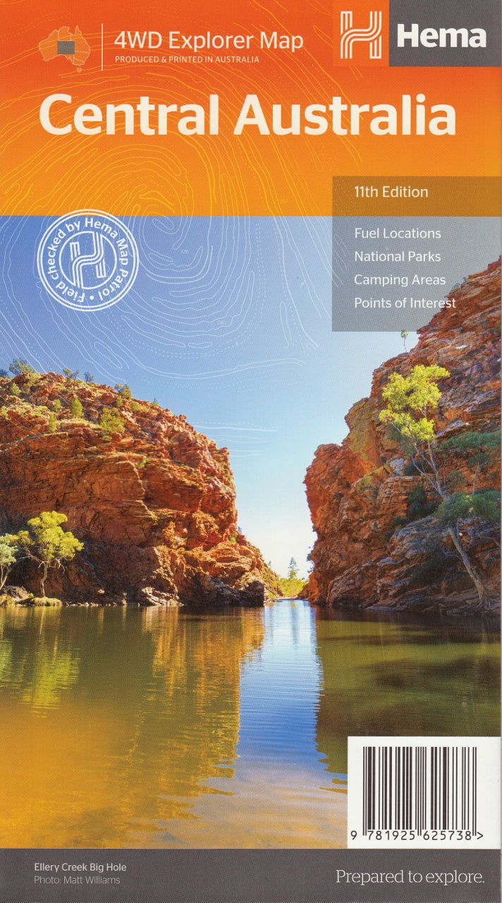
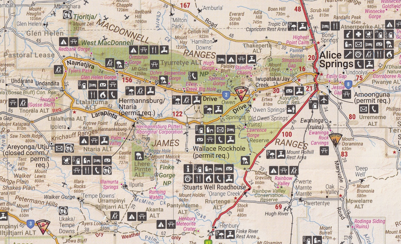
Central Australia Map – Hema Maps (11th Edition) NEW
$14.95 $15.95
Afterpay is only available for orders between $50.00 and $1000.00 More info
Your essential companion for navigating the remote heart of Australia with confidence, clarity, and adventure in mind.
The Hema Central Australia Map (11th Edition) is the definitive map for exploring the rugged landscapes and remote routes of the Australian Outback. Whether you're tracing the red sands of the Simpson Desert, marvelling at the majesty of Uluru, or winding through the ancient gorges of the West MacDonnell Ranges, this comprehensive double-sided map provides everything you need to plan, travel, and explore safely.
Meticulously researched and GPS field-checked by the renowned Hema Map Patrol, this map covers one of the most remote and awe-inspiring regions on earth. It’s an indispensable tool for 4WD travellers, campers, caravanners, bushwalkers, and cultural explorers alike.
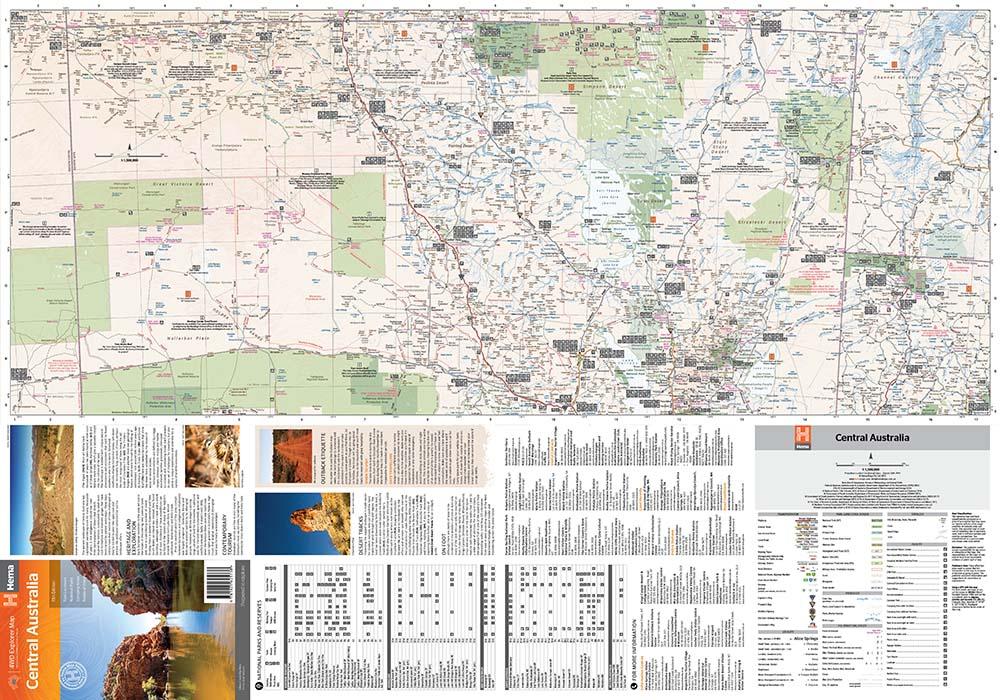
🗺️ Regional Coverage
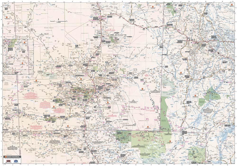
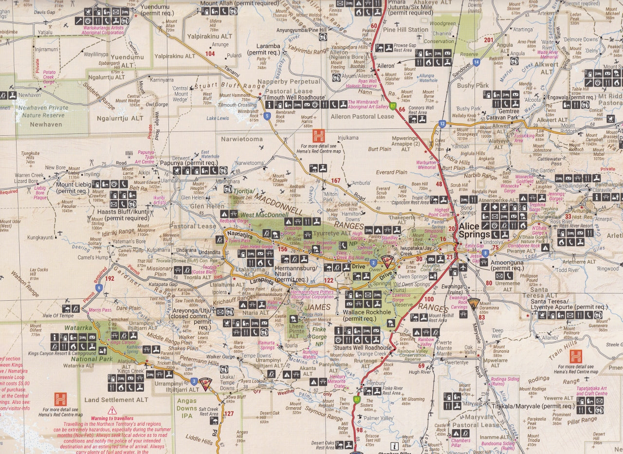
Spanning a vast and wild territory, this map includes the most iconic destinations and key travel corridors in Central Australia, including:
-
Alice Springs and surrounding bushland
-
Uluru–Kata Tjuta National Park
-
Kings Canyon and Watarrka National Park
-
West & East MacDonnell Ranges
-
Simpson Desert & Hay River Track
-
Finke Gorge & Palm Valley
-
Plenty Highway and Sandover Highway
-
Mount Dare, Andado Station, Old Ghan Railway, Chambers Pillar
-
Border regions with South Australia, Western Australia, and the Northern Territory
The map also includes major 4WD routes, desert crossings, Indigenous lands, and remote settlements such as Papunya, Kintore, and Docker River.
🌄 Key Features
-
Scale: 1:1,500,000 – ideal for regional navigation with sufficient detail for planning
-
National Parks and Indigenous Land:
-
Clearly marked with park names, access points, and permit requirements
-
Information on visitor facilities, walks, and cultural heritage zones
-
-
Topographic relief shading to highlight terrain and elevation changes
-
Detailed road network, including:
-
Sealed roads, unsealed roads, 4WD-only tracks, private station roads
-
Road distances, fuel stops, rest areas, and roadhouses
-
-
GPS-located campsites with symbols for facilities such as:
-
Toilets, water access, BBQs, and showers
-
24-hour fuel and mechanical services
-
-
Tourist information centres and emergency contacts
-
Map insets for high-use regions such as Alice Springs and Uluru–Kata Tjuta
🧭 Special Features
-
Historic Route Markings: Old Ghan Railway, explorer routes, heritage trails
-
Outback travel tips: Warnings on fuel range, vehicle preparation, and safety advice
-
Permit zones: Clearly defined Aboriginal land boundaries with key permit requirements and access notes
-
Wildlife, conservation areas, and walking trails for ecotourism and bushwalking
-
Geological and natural landmarks, such as meteorite craters, salt lakes, and escarpments
📐 Product Details
-
Edition: 11th
-
Publication Date: April 2019
-
Printed on: Waterproof, tear-resistant synthetic paper – built for harsh desert conditions
-
Folded Size: 140 mm x 250 mm
-
Flat Size: 700 mm x 1000 mm
-
Weight: Approx. 70 grams
-
Printed in: Australia
-
Publisher: Hema Maps
🎯 Who Should Use This Map?
-
4WD travellers and off-road explorers
-
Caravanners and campers seeking outback rest areas and remote tracks
-
Bushwalkers and hikers exploring the Larapinta Trail, Kings Canyon Rim Walk, or Simpson crossings
-
Tourists and photographers following the red centre’s world-famous landmarks
-
Educators and students studying Australian geography, ecology, or Aboriginal land tenure
-
Expedition teams and outback tour operators
🌟 Why Choose the Hema Central Australia Map?
-
Created by the Hema Map Patrol — Australia’s leading off-road mapping team
-
Field-checked and GPS verified for maximum accuracy
-
Provides peace of mind in areas with limited or no mobile reception
-
Designed specifically for outback travel and planning, including preparation and navigation tips
-
Complements the Hema Great Desert Tracks and Simpson Desert maps, as well as HEMA’s 4WD Map Pack
🧳 Final Thought
The Red Centre is more than just a destination — it's a journey into the soul of Australia. From the sacred presence of Uluru to the desolate beauty of the Simpson’s endless dunes, Central Australia rewards the prepared and the adventurous.
The Hema Central Australia Map (11th Edition) is more than a map — it's a lifeline, a travel planner, and a window into one of the world’s most remote and captivating regions.
Go prepared. Travel safe. Explore deeper — with Hema by your side.


