- Australia ▾
- Topographic
▾
- Australia AUSTopo 250k (2025)
- Australia 50k Geoscience maps
- Australia 100k Geoscience maps
- Australia 250k Geoscience maps
- Australia 1:1m Geoscience maps
- New Zealand 50k maps
- New Zealand 250k maps
- New South Wales 25k maps
- New South Wales 50k maps
- New South Wales 100k maps
- Queensland 10k maps
- Queensland 25k maps
- Queensland 50k maps
- Queensland 100k maps
- Compasses
- Software
- GPS Systems
- Orienteering
- International ▾
- Wall Maps
▾
- World
- Australia & New Zealand
- Countries, Continents & Regions
- Historical
- Vintage National Geographic
- Australian Capital Territory
- New South Wales
- Northern Territory
- Queensland
- South Australia
- Tasmania
- Victoria
- Western Australia
- Celestial
- Children's
- Mining & Resources
- Wine Maps
- Healthcare
- Postcode Maps
- Electoral Maps
- Nautical ▾
- Flags
▾
- Australian Flag Sets & Banners
- Flag Bunting
- Handwavers
- Australian National Flags
- Aboriginal Flags
- Torres Strait Islander Flags
- International Flags
- Flagpoles & Accessories
- Australian Capital Territory Flags
- New South Wales Flags
- Northern Territory Flags
- Queensland Flags
- South Australia Flags
- Tasmania Flags
- Victoria Flags
- Western Australia Flags
- Gifts ▾
- Globes ▾
Dear valued customer. Please note that our checkout is not supported by old browsers. Please use a recent browser to access all checkout capabilities


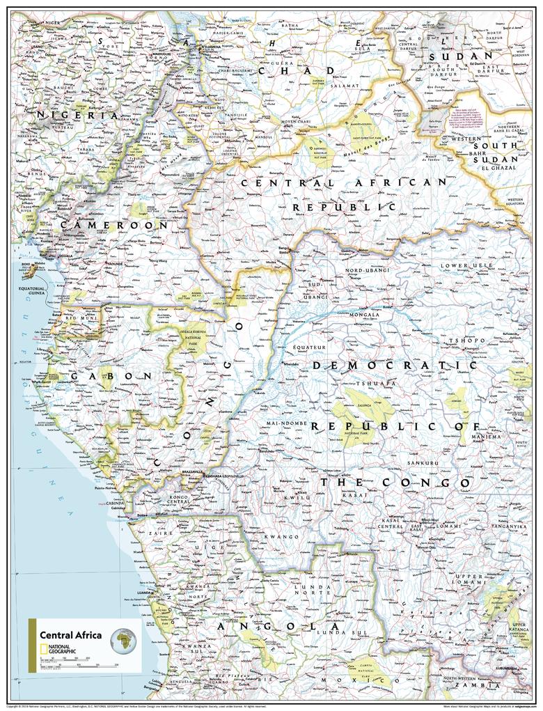
Central Africa Atlas of the World, 11th Edition, National Geographic Wall Map
$69.95
or make 4 interest-free payments of
$17.49 AUD
fortnightly with
![]() More info
More info
🌍 Central Africa Wall Map
National Geographic | Atlas of the World, 11th Edition
Available Sizes:
📏 Standard: 790 x 610 mm
🗺️ Supermap: 915 x 1197 mm
Where natural wonders meet political complexity—Central Africa brought to life.
Step into the heart of Africa with the Central Africa Wall Map from National Geographic’s acclaimed 11th Edition Atlas of the World. Combining the finest in modern cartographic precision with National Geographic’s signature style, this map offers a stunning overview of Central Africa’s physical geography and political boundaries.
From the Congo Basin’s lush rainforests to the volcanic peaks and river systems that define the region, this map doesn’t just inform—it immerses. It is equally at home in a classroom, boardroom, library, or personal study—wherever geographic knowledge and world awareness matter.
🗺️ What This Map Shows
This hybrid physical and political wall map reveals both the environmental richness and geopolitical structure of one of the most vital and complex regions on Earth:
🔹 Physical Features
-
🌄 Mountain ranges, valleys, plateaus, and escarpments depicted in shaded relief
-
💧 Rivers, lakes, and drainage systems—showing the lifelines of the Congo and beyond
-
🏜️ Terrain textures that distinguish rainforests, savannas, swamps, and arid zones
🔹 Political Boundaries
-
🌐 Country borders clearly marked with high contrast and colour-coded territories
-
🏙️ Major cities and capitals labelled with precision
-
🛂 International boundaries and disputed territories noted where applicable
🧭 Projection & Design
-
📏 Transverse Mercator projection, ideal for regional accuracy and navigational reference
-
🎨 Classic National Geographic colour palette with blue oceans and land in natural earth tones
-
🧠 Carefully balanced typography for optimal legibility, even from a distance
🧑🏫 Ideal For:
✔️ Classrooms – especially those focused on geography, environmental science, international studies, or African history
✔️ Libraries & Universities – reference and display in research spaces or reading rooms
✔️ Government or NGO Offices – regional context for humanitarian work, resource planning, or logistics
✔️ Home & Office Walls – a meaningful décor piece for anyone fascinated by African geography
✔️ Map Enthusiasts & Collectors – part of National Geographic’s prestigious world atlas series
🖼️ Available Sizes & Best Uses
| Size | Dimensions | Best For |
|---|---|---|
| Standard | 790 x 610 mm | Smaller spaces, classrooms, study nooks |
| Supermap | 915 x 1197 mm | Offices, libraries, conference rooms |
Both sizes are available in multiple finishes to suit different needs and environments.
✨ Premium Format Options
| Format | Material & Finish | Best Use |
|---|---|---|
| Paper | 160gsm heavyweight matte paper | Ideal for framing under glass |
| Laminated | Gloss-laminated on both sides (80-micron encapsulation) – waterproof and whiteboard marker friendly | Perfect for classrooms, planning, or reusable annotation |
| Canvas | Printed on 395gsm HP matte artist’s canvas using fade-resistant pigment inks | Long-term decorative use with a gallery-quality finish |
➕ Optional handcrafted timber hang rails available for laminated and canvas versions to create a ready-to-hang display.
🪚 Timber Hang Rails – Optional Upgrade
Elevate your map from functional to decorative with our premium hang rail option:
-
🪵 Natural timber rails, satin-lacquered for a clean, contemporary finish
-
🧵 Top rail includes hanging cord for easy wall mounting
-
🖐️ Hand-fitted by a professional framer to ensure perfect alignment
-
⏳ Please allow up to 10 working days for hang rail assembly and dispatch
A stylish finish that turns your map into a centerpiece.
📐 Specifications
| Specification | Details |
|---|---|
| Map Title | Central Africa Wall Map |
| Publisher | National Geographic |
| Edition | Atlas of the World, 11th Edition |
| Year Published | 2019 |
| Map Type | Physical and Political |
| Projection | Transverse Mercator |
| Standard Size | 790 mm (W) x 610 mm (H) |
| Supermap Size | 915 mm (W) x 1197 mm (H) |
| Print Origin | Printed and finished in Australia |
| Optional Add-ons | Timber hang rails (Laminated & Canvas versions) |
💡 Why This Map Belongs on Your Wall
✅ Dual Insight – Explore natural landforms and man-made borders in one elegant map
✅ Engages the Mind – Supports geographic literacy, regional awareness, and global thinking
✅ Ready to Teach – Perfect for pointing out political relationships and environmental features
✅ Beautifully Crafted – A seamless blend of data, design, and visual clarity
✅ A Trusted Name – National Geographic’s cartography is unmatched for authority and aesthetics
Let this Central Africa Wall Map bring the continent’s ecological complexity and political geography into sharp focus. Whether you're learning, teaching, planning, or simply appreciating—this map offers an immersive, intelligent view of the region.
📦 Shipping & Handling
-
📄 Paper & Laminated formats: Ships in 1–2 business days
-
🖼️ Canvas & Timber Rail formats: Please allow 7–10 business days for custom finishing
🛒 Add to Cart – Understand Central Africa at a Glance
Bring home a piece of the National Geographic legacy with this meticulously detailed and beautifully designed wall map.


