- Australia ▾
- Topographic
▾
- Australia AUSTopo 250k (2024)
- Australia 50k Geoscience maps
- Australia 100k Geoscience maps
- Australia 250k Geoscience maps
- Australia 1.1m Geoscience maps
- New Zealand 50k maps
- New Zealand 250k maps
- New South Wales 25k maps
- New South Wales 50k maps
- New South Wales 100k maps
- Queensland 10k maps
- Queensland 25k maps
- Queensland 50k maps
- Queensland 100k maps
- Compasses
- Software
- GPS Systems
- Orienteering
- International ▾
- Wall Maps
▾
- World
- Australia & New Zealand
- Countries, Continents & Regions
- Historical
- Vintage National Geographic
- Australian Capital Territory
- New South Wales
- Northern Territory
- Queensland
- South Australia
- Tasmania
- Victoria
- Western Australia
- Celestial
- Children's
- Mining & Resources
- Wine Maps
- Healthcare
- Postcode Maps
- Electoral Maps
- Nautical ▾
- Flags
▾
- Australian Flag Sets & Banners
- Flag Bunting
- Handwavers
- Australian National Flags
- Aboriginal Flags
- Torres Strait Islander Flags
- International Flags
- Flagpoles & Accessories
- Australian Capital Territory Flags
- New South Wales Flags
- Northern Territory Flags
- Queensland Flags
- South Australia Flags
- Tasmania Flags
- Victoria Flags
- Western Australia Flags
- Gifts ▾
- Globes ▾
Dear valued customer. Please note that our checkout is not supported by old browsers. Please use a recent browser to access all checkout capabilities


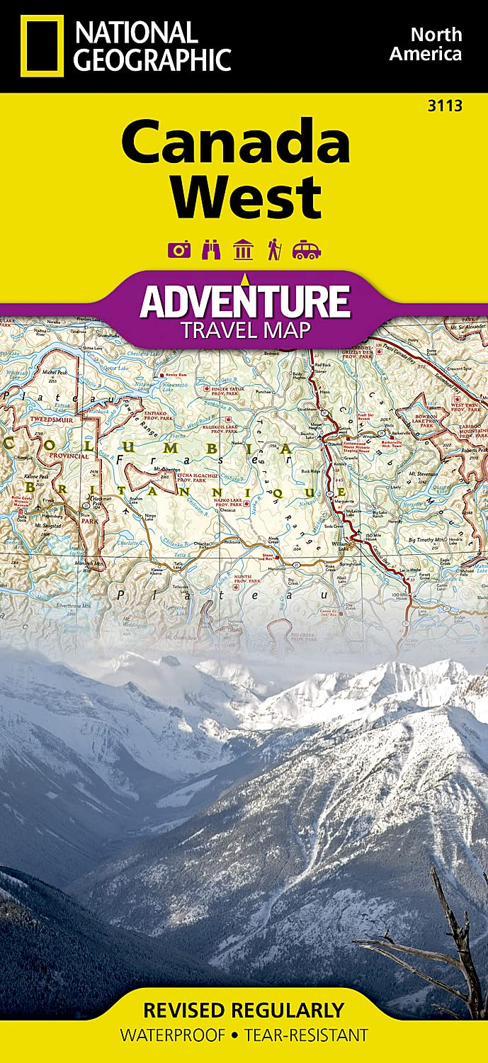
Canada West National Geographic Folded Map
$26.95
Afterpay is only available for orders between $50.00 and $1000.00 More info
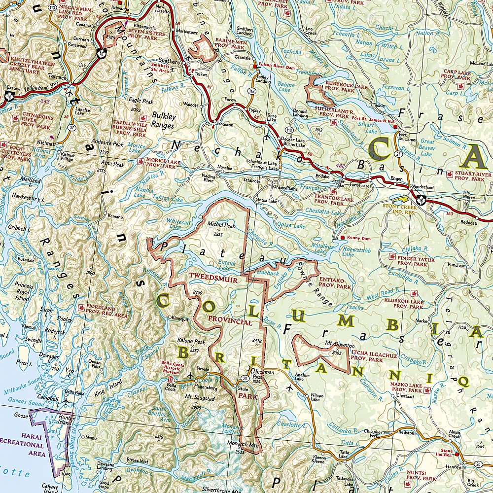
🇨🇦 Canada West National Geographic Adventure Map
Durable, Waterproof Travel Map – Featuring the Rockies, Yukon, Vancouver Island & Beyond
Scale: 1:2,000,000 | Size: 965 mm x 660 mm | Folded: 235 mm x 108 mm
🧭 Explore the Wild Beauty of Western Canada
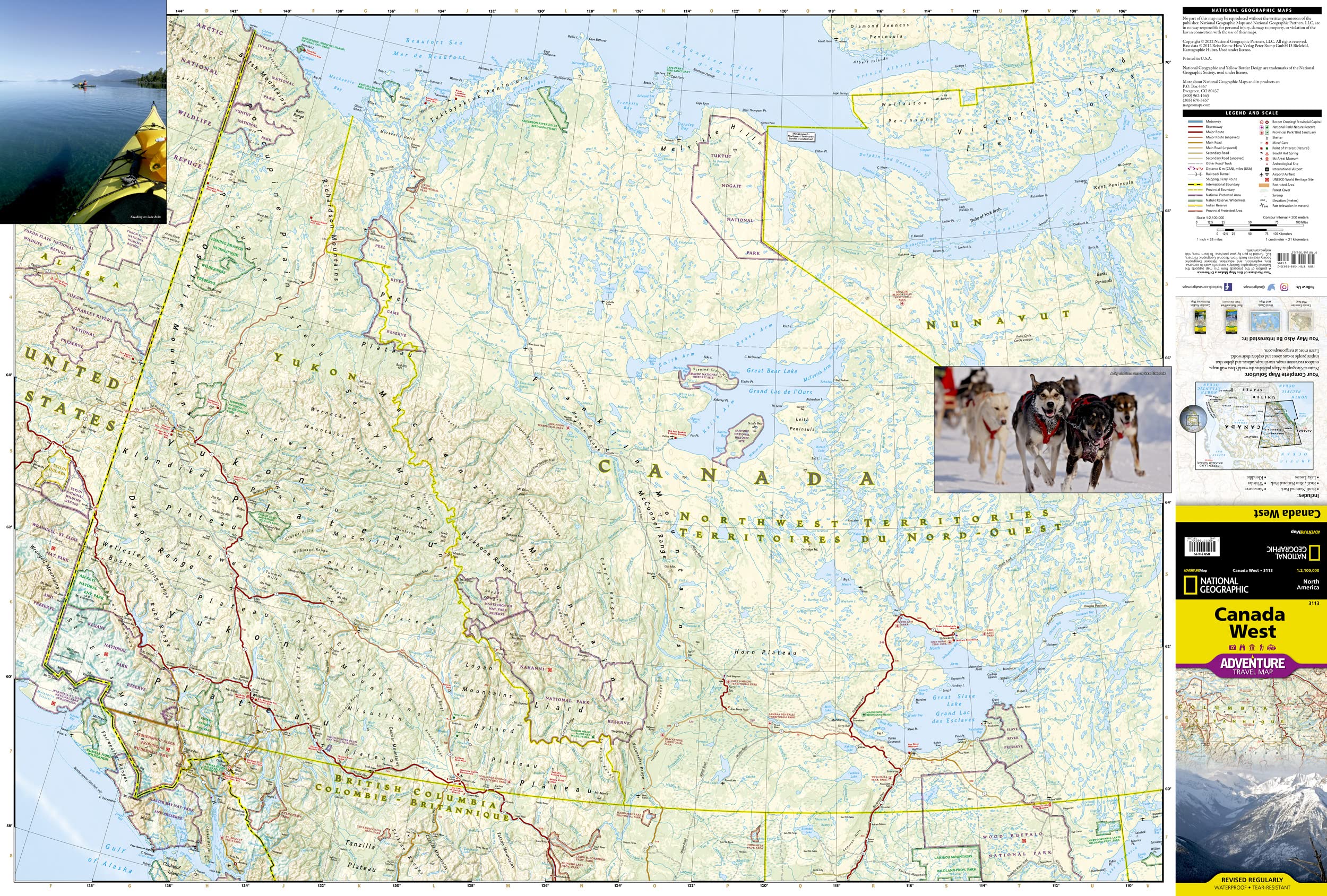
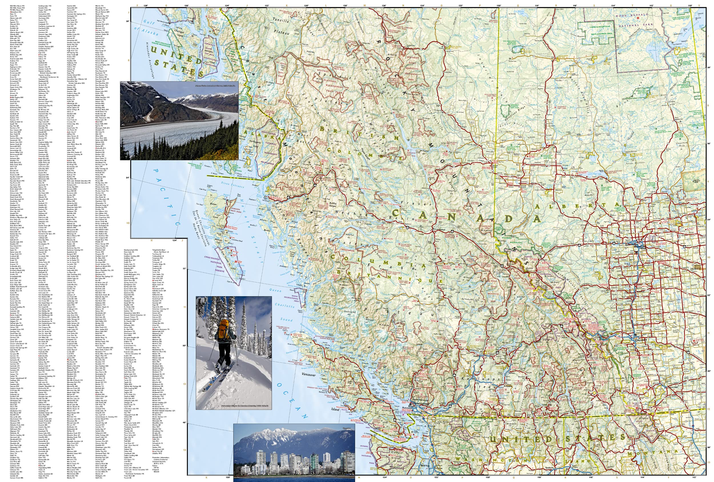
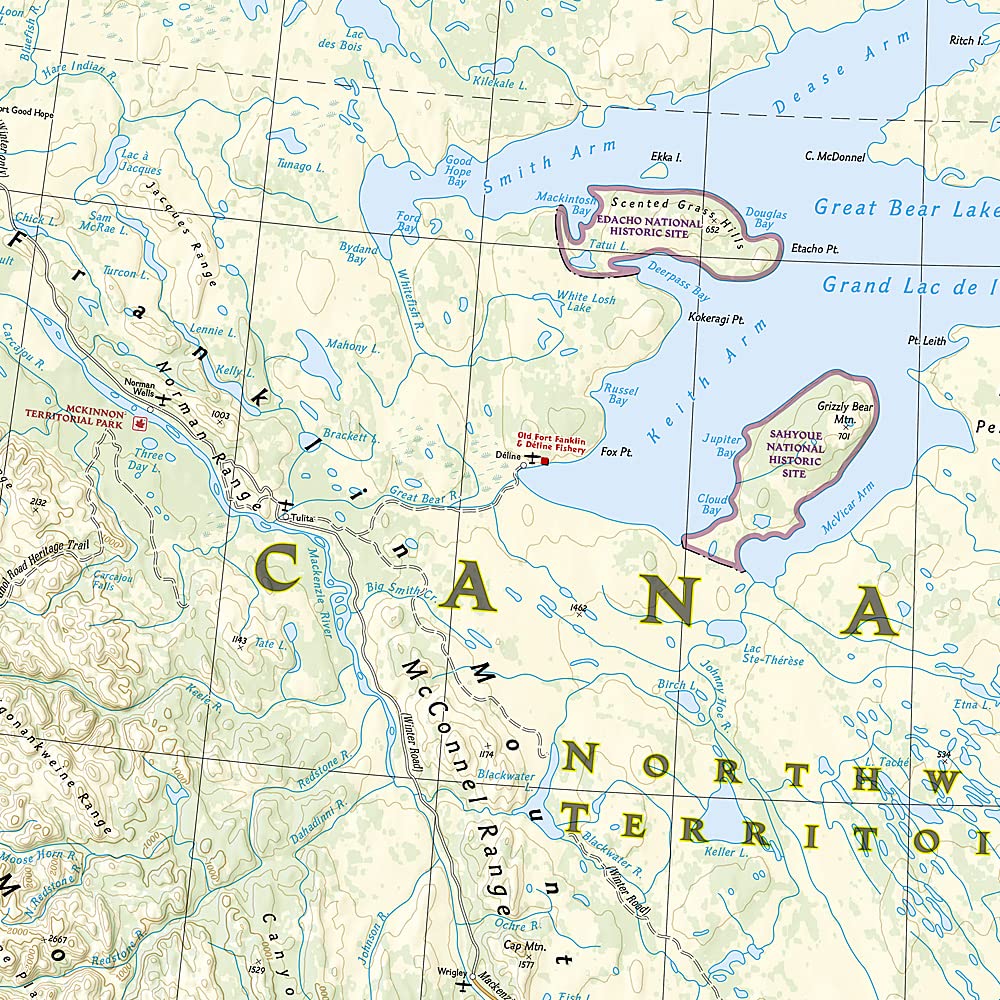
From the Pacific Coast to the Yukon Plateau, the Canada West Adventure Map by National Geographic is your rugged and reliable companion through some of the most spectacular landscapes in North America. Designed specifically for adventure travellers, this detailed map spans the provinces of British Columbia, Alberta, and the Yukon and Northwest Territories, highlighting world-famous natural wonders like Banff and Jasper National Parks, Vancouver Island, Whistler, and the Nahanni National Park Reserve, a UNESCO World Heritage Site.
✅ Key Features
-
🗺️ Double-Sided Design
-
Front Side: Victoria Island, Great Bear Lake, Great Slave Lake, Prince Albert Sound, the Yukon Plateau, and the Northwest Territories.
-
Back Side: Queen Charlotte Islands (Haida Gwaii), Vancouver Island, Coast Mountains, Canadian Rockies, Alberta, and the southern British Columbia interior.
-
-
🧭 Accurate Topography & Terrain
Detailed relief shading and elevation contours provide clear representation of mountain ranges, rivers, lakes, and other natural features. -
🚗 Clearly Marked Road Network
Primary and secondary highways, scenic routes, and remote access roads are all labeled with distances and road designations. -
🏞 Hundreds of Points of Interest
Includes national parks, nature reserves, hiking and paddling areas, historical and cultural sites, and ecological landmarks. -
✈️ Practical Travel Aids
Includes airports, rail lines, ferry routes, border crossings, latitude/longitude grid, UTM references, and compass rose.
📏 Specifications
| Attribute | Details |
|---|---|
| Publisher | National Geographic Maps |
| Series | Adventure Maps |
| Map Scale | 1:2,000,000 |
| Size (unfolded) | 965 mm x 660 mm |
| Size (folded) | 235 mm x 108 mm |
| Material | Synthetic paper (waterproof & tear-resistant) |
| Printing Origin | Made in the USA |
💼 Why Choose This Map?
| Feature | Benefit |
|---|---|
| 🧳 Compact and lightweight | Folds neatly for easy travel use and storage |
| 💧 Waterproof and tear-resistant | Ideal for backcountry or multi-day trips in all weather |
| 🗺️ Adventure-ready coverage | Focused on natural, cultural, and recreational landmarks |
| 🧭 Compass and GPS compatible | Includes grid coordinates and scale bars for accurate navigation |
| 🧠 Trusted National Geographic brand | Backed by decades of cartographic expertise and exploration |
🌎 Who’s It For?
-
🚐 RV travellers & road-trippers exploring the Trans-Canada and beyond
-
🏕️ Outdoor adventurers visiting national parks, lakes, and wilderness areas
-
🎒 Backpackers & hikers tackling alpine trails and backcountry routes
-
📚 Educators and students studying Canadian geography or planning field work
-
📍 Travel planners looking for a durable, high-quality overview of Western Canada
Travel with Purpose
Every purchase of a National Geographic map helps support the National Geographic Society’s vital work in exploration, conservation, education, and research. With every journey you take, you contribute to a global mission of discovery.
Whether you're skiing in Whistler, paddling the Nahanni River, chasing northern lights in the Yukon, or road-tripping the Icefields Parkway, the Canada West Adventure Map is built to go the distance with you — and back.
🛒 Order now and start planning your ultimate Canadian adventure.


