- Australia ▾
- Topographic
▾
- Australia AUSTopo 250k (2024)
- Australia 50k Geoscience maps
- Australia 100k Geoscience maps
- Australia 250k Geoscience maps
- Australia 1.1m Geoscience maps
- New Zealand 50k maps
- New Zealand 250k maps
- New South Wales 25k maps
- New South Wales 50k maps
- New South Wales 100k maps
- Queensland 10k maps
- Queensland 25k maps
- Queensland 50k maps
- Queensland 100k maps
- Compasses
- Software
- GPS Systems
- Orienteering
- International ▾
- Wall Maps
▾
- World
- Australia & New Zealand
- Countries, Continents & Regions
- Historical
- Vintage National Geographic
- Australian Capital Territory
- New South Wales
- Northern Territory
- Queensland
- South Australia
- Tasmania
- Victoria
- Western Australia
- Celestial
- Children's
- Mining & Resources
- Wine Maps
- Healthcare
- Postcode Maps
- Electoral Maps
- Nautical ▾
- Flags
▾
- Australian Flag Sets & Banners
- Flag Bunting
- Handwavers
- Australian National Flags
- Aboriginal Flags
- Torres Strait Islander Flags
- International Flags
- Flagpoles & Accessories
- Australian Capital Territory Flags
- New South Wales Flags
- Northern Territory Flags
- Queensland Flags
- South Australia Flags
- Tasmania Flags
- Victoria Flags
- Western Australia Flags
- Gifts ▾
- Globes ▾
Dear valued customer. Please note that our checkout is not supported by old browsers. Please use a recent browser to access all checkout capabilities


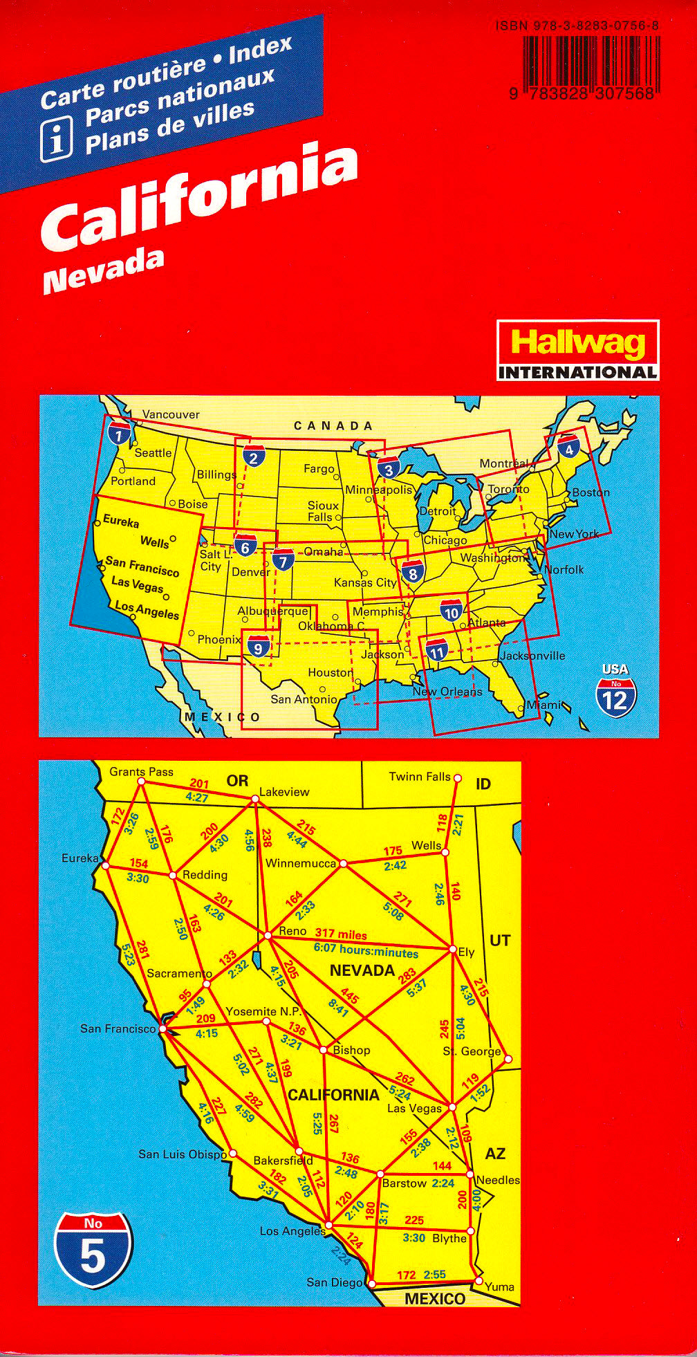
California Hallwag USA Map
$24.95
Afterpay is only available for orders between $50.00 and $1000.00 More info
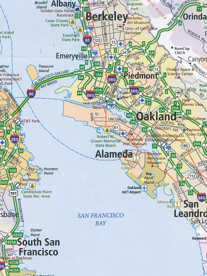
Explore the golden landscapes of California and the rugged wilderness of Nevada with this beautifully detailed and practical touring map from Hallwag.
Whether you’re embarking on a classic road trip along Highway 1, seeking adventure in Yosemite or Death Valley, or navigating the neon sprawl of Las Vegas, the Hallwag California & Nevada Road Map is your essential travel companion. Designed for long-distance driving, sightseeing, and adventure planning, this map offers unparalleled clarity and coverage of two of the American West's most diverse and iconic states.
🗺️ Comprehensive Coverage
This map extends well beyond the state lines, giving you a broad, practical overview that stretches from:
-
Eureka in Northern California to the Mexican border in the south
-
San Francisco and the Pacific Coast east to Salt Lake City, Utah
-
Includes Los Angeles, San Diego, Las Vegas, Reno, Sacramento, and Lake Tahoe
This regional approach is perfect for cross-border planning and multi-state itineraries.
🧭 Key Features
-
Scale: 1:1,000,000 (1 cm = 10 km) – strikes a balance between detail and big-picture planning
-
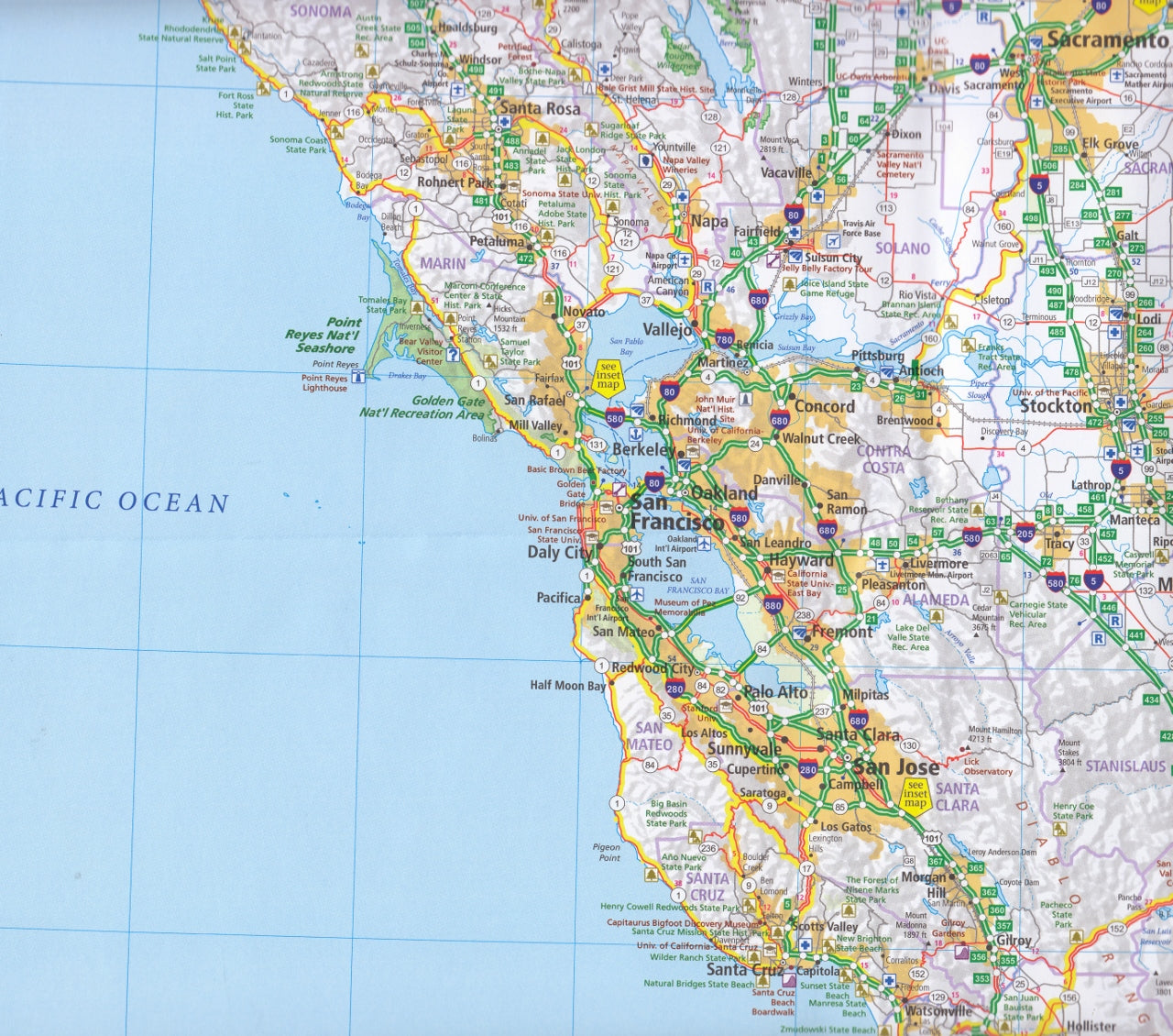
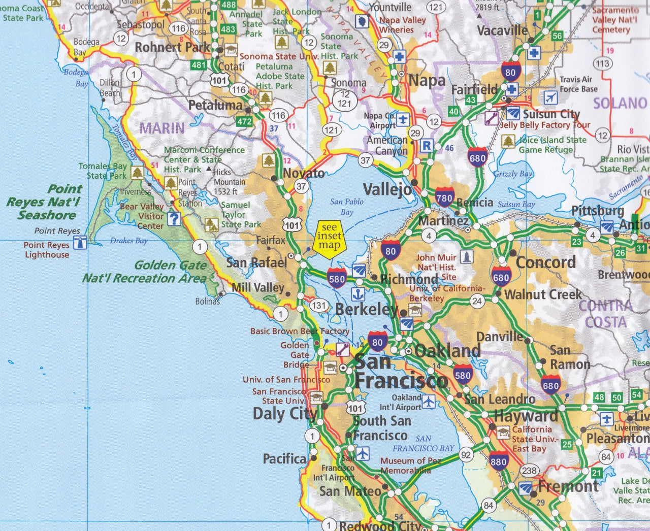
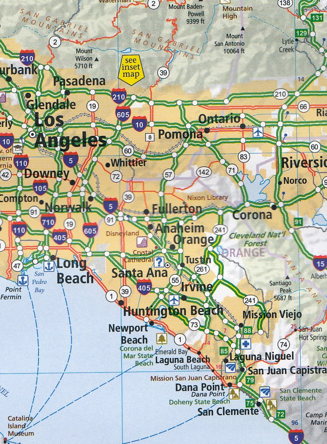
Fully indexed: Towns, cities, tourist attractions, highways, and scenic byways are easy to locate
-
Clear cartography: Hallwag’s renowned design makes roads, elevation changes, and features simple to interpret on the go
-
Durable & foldable: Ideal for glove boxes, backpacks, or dashboards
🌲 National Parks & Scenic Routes
This map also includes detailed inset maps of some of the region’s most famous national parks:
-
Yosemite National Park
-
Sequoia & Kings Canyon
-
Death Valley
-
Redwood National Park
-
Crater Lake (Oregon)
Additional symbols highlight parks, monuments, nature reserves, camping areas, ski resorts, and world-renowned scenic drives like the Pacific Coast Highway, Tioga Pass, and Lake Tahoe Rim.
🏙️ Inset City Maps
To support urban navigation, the map features detailed street-level insets of:
-
San Francisco
-
Los Angeles
-
San Diego
-
Sacramento
-
San Jose
-
Las Vegas
-
Riverside/San Bernardino
These insets allow you to move seamlessly from interstate driving to local street navigation, making this map incredibly versatile for both rural and urban travel.
📚 Bonus Booklet
Included with the map is a travel guide booklet, providing:
-
A comprehensive index of all places shown
-
Tourist information, including notable landmarks, scenic highlights, and regional insights
-
Multilingual content in English, French, and German
📐 Map Specifications
-
Unfolded size: 138 cm × 100 cm
-
Folded size: 25 cm × 13 cm × 1.2 cm
-
Weight: Approx. 152 g
-
Format: Folded, printed on high-quality coated paper
-
ISBN: 9783828310933
-
Edition: Most recent (typically updated every 2–3 years)
🎯 Who’s It For?
-
Road trippers exploring the American West
-
Holidaymakers seeking flexible, offline travel tools
-
National park enthusiasts navigating remote scenic routes
-
Adventure travellers and RV campers mapping out large-scale journeys
-
Tour operators, travel agents, and educators requiring reliable reference tools
🛍️ Where to Buy
Available from leading map retailers and travel suppliers:
-
Mapworld Australia – View Product
-
Hema Maps Partners
-
Amazon & Walmart
-
Specialty bookstores and outdoor retailers
🌎 Why Choose Hallwag?
Hallwag maps are known worldwide for their cartographic excellence, travel-friendly design, and practical, up-to-date information. The California & Nevada Road Map exemplifies this with:
-
Elegant layout and rich detail
-
Scenic route highlights and regional insights
-
Touring-friendly scale and readability
From the coastal curves of Big Sur to the dusty trails of Death Valley, from urban highways to pine-covered Sierra peaks—this is the map that gets you there, confidently.
Explore more. Discover better. Travel with Hallwag.