- Australia ▾
- Topographic
▾
- Australia AUSTopo 250k (2025)
- Australia 50k Geoscience maps
- Australia 100k Geoscience maps
- Australia 250k Geoscience maps
- Australia 1:1m Geoscience maps
- New Zealand 50k maps
- New Zealand 250k maps
- New South Wales 25k maps
- New South Wales 50k maps
- New South Wales 100k maps
- Queensland 10k maps
- Queensland 25k maps
- Queensland 50k maps
- Queensland 100k maps
- Western Australia 25k maps
- Western Australia 50k maps
- Western Australia 100k maps
- Compasses
- Software
- GPS Systems
- International ▾
- Wall Maps
▾
- World
- Australia & New Zealand
- Countries, Continents & Regions
- Historical
- Vintage National Geographic
- Australian Capital Territory
- New South Wales
- Northern Territory
- Queensland
- South Australia
- Tasmania
- Victoria
- Western Australia
- Celestial
- Children's
- Mining & Resources
- Wine Maps
- Healthcare
- Postcode Maps
- Electoral Maps
- Nautical ▾
- Flags
▾
- Australian Flag Sets & Banners
- Flag Bunting
- Handwavers
- Australian National Flags
- Aboriginal Flags
- Torres Strait Islander Flags
- International Flags
- Flagpoles & Accessories
- Australian Capital Territory Flags
- New South Wales Flags
- Northern Territory Flags
- Queensland Flags
- South Australia Flags
- Tasmania Flags
- Victoria Flags
- Western Australia Flags
- Gifts ▾
- Globes ▾
Dear valued customer. Please note that our checkout is not supported by old browsers. Please use a recent browser to access all checkout capabilities


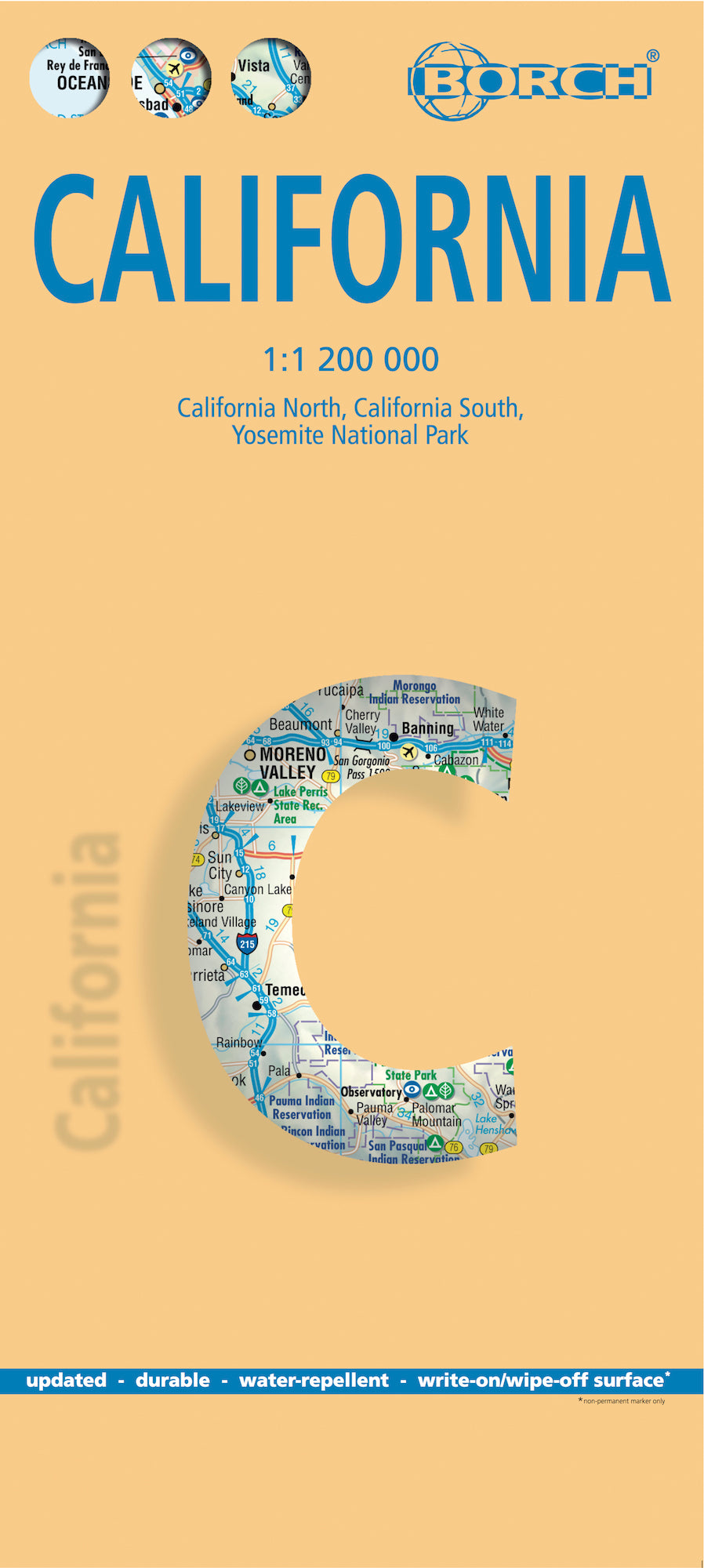
California Borch Folded Laminated Map
$21.95
Afterpay is only available for orders between $50.00 and $1000.00 More info
Scale: 1:1,200,000
ISBN-13: 978-3-86609-345-4
Map Size (Unfolded): 660 mm x 494 mm (26 in x 19.5 in)
Folded Size: 243 mm (H) x 110 mm (W) x 8 mm (D)
Weight: 60 g (2.1 oz)
Edition: 12th Edition (2022)
Format: Folded, soft-laminated (wipeable & water-resistant)
Publisher: BORCH
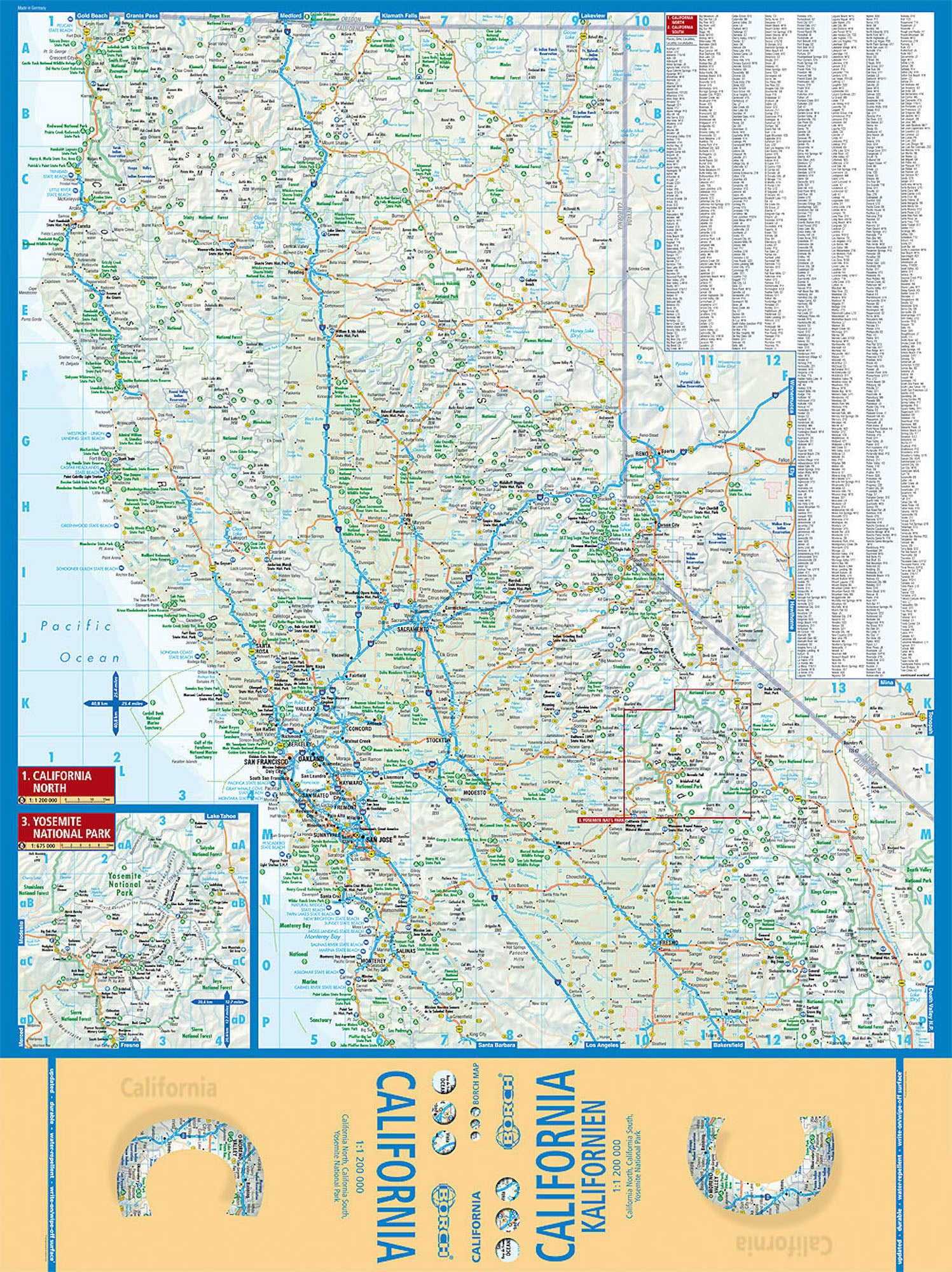
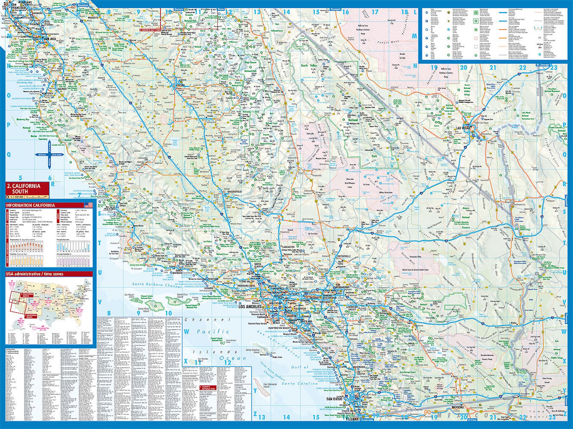
🧭 Map Details & Insets
This professionally designed map includes detailed, colour-coded regional breakdowns of the Golden State:
-
California North – 1:1,200,000
-
California South – 1:1,200,000
-
Yosemite National Park – 1:675,000
-
USA Administrative Divisions & Time Zones
Each section is easy to read, practical to navigate, and updated with current topographic and travel information.
🧳 Travel Features & Highlights
✔️ Durable Lamination – waterproof, tear-resistant, and reusable
✔️ Wipe-Clean Surface – mark and re-mark your routes with a whiteboard pen
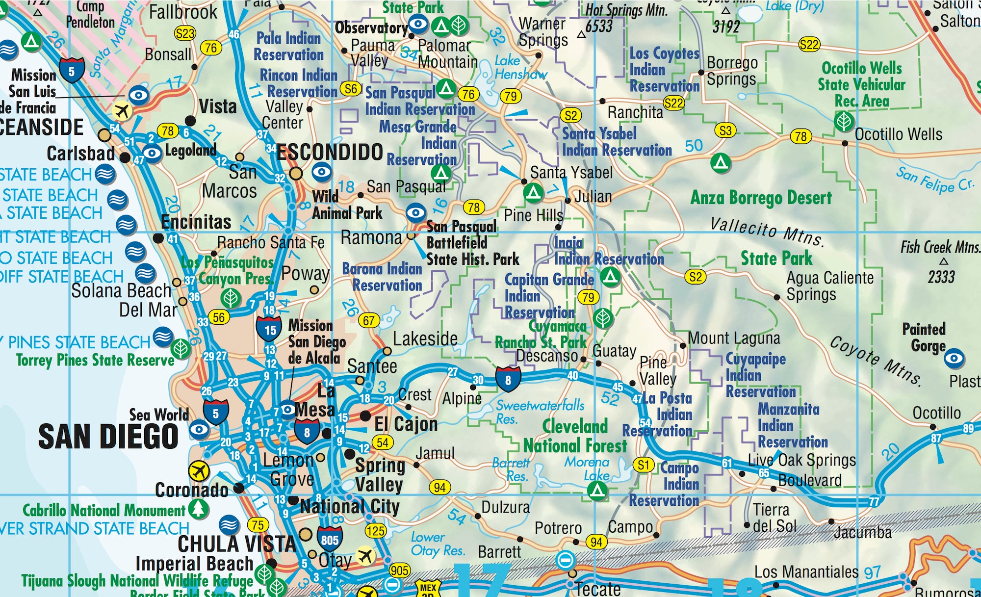
✔️ Accurate Road & Highway Details – from interstates to scenic backroads
✔️ Public Transport & Regional Rail – includes networks around major urban centres
✔️ Climate Charts – monthly averages for temperature, rainfall, humidity, and sunshine
✔️ Distance Tables – travel time and road distance estimations
✔️ Top Tourist Sites – natural wonders, city landmarks, museums, markets, and attractions
✔️ Easy Folding – compact and portable for daily travel use
✔️ Conversion Tables – helpful charts for metric/imperial users
🌄 Discover California’s Iconic Landscapes
From the windswept cliffs of Big Sur to the stark dunes of Death Valley, this map is your passport to California’s rich diversity of experiences. Explore:
-
🌁 San Francisco: Golden Gate Bridge, Alcatraz, and buzzing neighbourhoods
-
🌴 Los Angeles: Home of Hollywood, Venice Beach, Griffith Park, and endless glamour
-
🏞️ Yosemite & Sequoia: Hike glacier-carved valleys and meet the tallest trees on Earth
-
🏖️ San Diego: Surf, tacos, and the laid-back vibe of SoCal living
-
🌅 Palm Springs & Joshua Tree: Desert serenity, rock formations, and stargazing
-
🎡 Anaheim & Disneyland: The magic of childhood and thrills of adventure parks
-
🛷 Lake Tahoe & the Sierra Nevada: Ideal for skiing, snowboarding, hiking, and lakeside retreats
-
🏜️ Death Valley: Explore the hottest, driest place in North America
California offers it all — whether you're chasing sunsets down Pacific Coast Highway, trekking through alpine forests, or weaving through vineyards in Napa.
💡 Why Choose This Map?
| 🧾 Feature | 💬 Benefit |
|---|---|
| Soft-Laminated & Folded | Travel-ready, resilient to weather and wear |
| Multi-Scale Coverage | Navigate large regions and local parks with ease |
| Tourism-Ready | Ideal for planning road trips, sightseeing, and detours |
| No Batteries Needed | Reliable when phone signals drop — a must for remote areas |
| Wipeable Surface | Use again and again — perfect for plotting multi-day routes |
| Compact | Fits in glove boxes, daypacks, or carry-on luggage |
🛍️ Perfect For:
-
🚐 Vanlife Explorers planning off-grid detours
-
🧳 International Travellers on their dream California trip
-
🧭 Roadtrippers mapping out the West Coast highways
-
🌄 Outdoor Adventurers seeking national parks and wild spaces
-
📸 Photographers & Creatives chasing the golden light of the West
-
🎓 Students & Educators needing a clear visual of California’s geography
🔍 Map Specs at a Glance
| Specification | Detail |
|---|---|
| Edition | 12th Edition (2022) |
| Publisher | BORCH |
| Scale | 1:1,200,000 |
| Unfolded Size | 660 mm x 494 mm (26 in x 19.5) |
| Folded Size | 243 mm x 110 mm x 8 mm |
| Weight | 60 g (2.1 oz) |
| Language | English, multilingual legend |
📌 Explore smarter. Travel farther. Discover California with BORCH — a map you’ll love using again and again.
Frequently Asked Questions
Where can I buy the California Borch Folded Laminated Map?
The California Borch Folded Laminated Map is available to buy online from Mapworld, Australia's largest map and geographic product retailer, with fast shipping Australia-wide.
Is the California Borch Folded Laminated Map in stock at Mapworld?
Mapworld maintains extensive stock across its map range and aims for fast dispatch. Orders placed before 2pm AEST on business days are typically dispatched the same day, with standard and express Australia-wide delivery options available.
What is Mapworld's returns policy?
Mapworld accepts returns on undamaged items in original condition. Contact Mapworld within 90 days of purchase to arrange a return or exchange.
Does Mapworld ship the California Borch Folded Laminated Map across Australia?
Yes, Mapworld ships Australia-wide. Standard shipping is a flat $7 rate, with free standard shipping on orders over $75. Express options are available at checkout. Most orders placed before 2pm AEST on weekdays are dispatched same day.
Related Items


© 2026 Mapworld. Website designed by Genie Media
X