- Australia ▾
- Topographic
▾
- Australia AUSTopo 250k (2025)
- Australia 50k Geoscience maps
- Australia 100k Geoscience maps
- Australia 250k Geoscience maps
- Australia 1:1m Geoscience maps
- New Zealand 50k maps
- New Zealand 250k maps
- New South Wales 25k maps
- New South Wales 50k maps
- New South Wales 100k maps
- Queensland 10k maps
- Queensland 25k maps
- Queensland 50k maps
- Queensland 100k maps
- Western Australia 25k maps
- Western Australia 50k maps
- Western Australia 100k maps
- Compasses
- Software
- GPS Systems
- International ▾
- Wall Maps
▾
- World
- Australia & New Zealand
- Countries, Continents & Regions
- Historical
- Vintage National Geographic
- Australian Capital Territory
- New South Wales
- Northern Territory
- Queensland
- South Australia
- Tasmania
- Victoria
- Western Australia
- Celestial
- Children's
- Mining & Resources
- Wine Maps
- Healthcare
- Postcode Maps
- Electoral Maps
- Nautical ▾
- Flags
▾
- Australian Flag Sets & Banners
- Flag Bunting
- Handwavers
- Australian National Flags
- Aboriginal Flags
- Torres Strait Islander Flags
- International Flags
- Flagpoles & Accessories
- Australian Capital Territory Flags
- New South Wales Flags
- Northern Territory Flags
- Queensland Flags
- South Australia Flags
- Tasmania Flags
- Victoria Flags
- Western Australia Flags
- Gifts ▾
- Globes ▾
Dear valued customer. Please note that our checkout is not supported by old browsers. Please use a recent browser to access all checkout capabilities


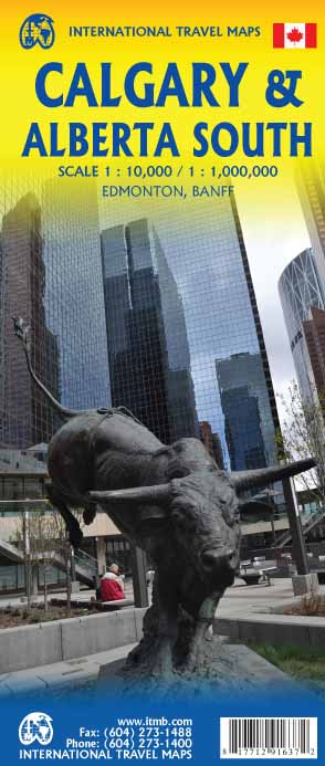
Calgary & Alberta South ITMB Map
$24.95
Afterpay is only available for orders between $50.00 and $1000.00 More info
Double-Sided Travel & Road Map | Includes Banff, Edmonton & Southern Alberta
Experience the energy of Calgary and the breathtaking landscapes of southern Alberta with this detailed two-in-one travel and road map from ITMB (International Travel Maps). Perfect for first-time visitors, road trippers, and adventure seekers, this map combines a comprehensive street map of Calgary with a regional map covering the southern half of Alberta—including parts of British Columbia and Saskatchewan.
Whether you’re arriving by international flight, planning a road trip through the Rockies, or heading to the legendary Calgary Stampede, this map delivers clarity, accuracy, and travel inspiration in equal measure.
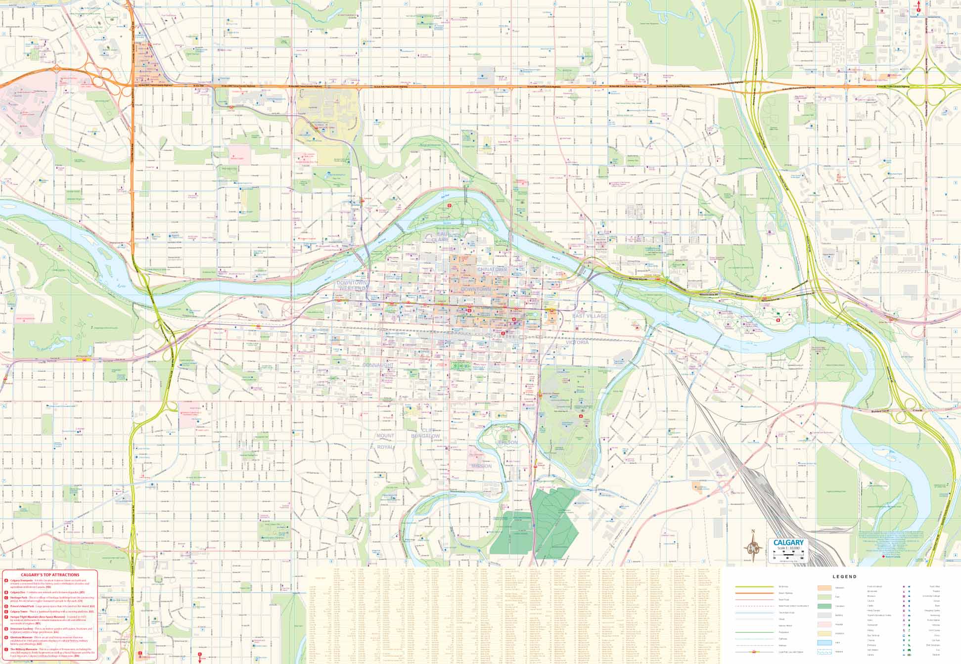
🏙️ Side 1 – City of Calgary
The first side focuses on Calgary, Alberta’s largest city and Canada’s oil industry hub.
Features include:
-
Detailed Street Layout – clearly marked roads, highways, and key intersections.
-
Neighbourhoods & Landmarks – parks, museums, shopping districts, and entertainment areas.
-
Transport Links – major roads to surrounding towns and highways to the Rockies.
-
Event Highlight – Calgary’s famous Stampede Rodeo, held every July, is a global attraction and a defining feature of the city’s cultural calendar.
-
Historic Roots – the city’s founding location tied to Canada’s first transcontinental rail line, linking Vancouver to Eastern Canada.
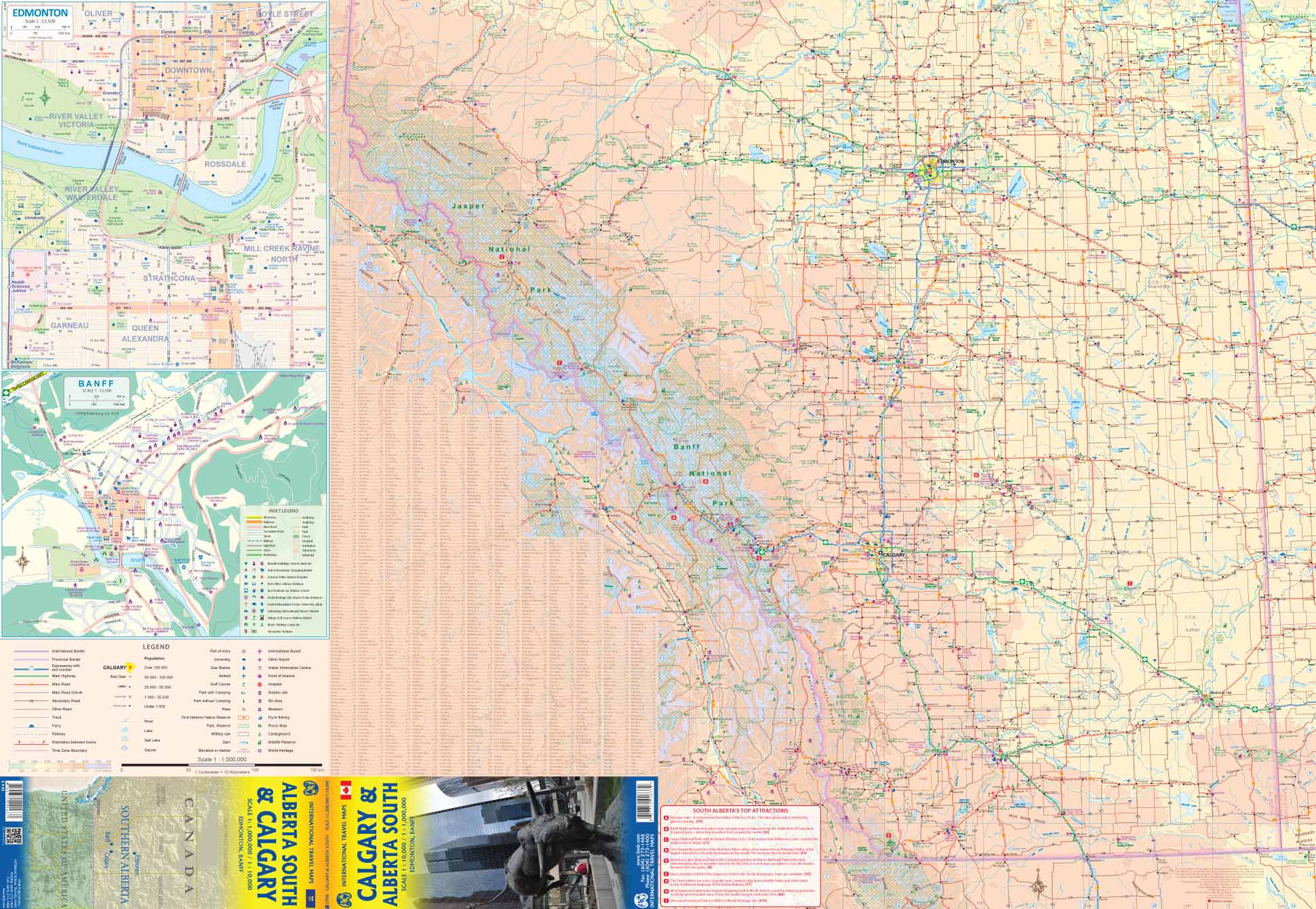
🏔️ Side 2 – Southern Alberta & Regional Highlights
The reverse side offers a broad regional map of southern Alberta, stretching:
-
From the American border in the south to Jasper National Park in the north.
-
From western Saskatchewan to the British Columbia border in the west.
Key inclusions:
-
Road Network Coverage – highways, secondary roads, and scenic routes clearly marked.
-
Inset Map of Banff – ideal for navigating Canada’s most famous mountain town.
-
Inset Map of Edmonton – coverage of Alberta’s capital city, located north of the main map area.
-
National Parks – Banff, Jasper (southern section), Waterton Lakes, and more.
-
Tourist Attractions – lakes, ski resorts, heritage sites, and natural landmarks identified.
🧭 Why This Map is Essential
-
✅ Two Maps in One – Calgary city detail on one side, regional Southern Alberta coverage on the reverse.
-
✅ Perfect for Short-Term Visitors – ideal for those exploring Calgary plus nearby attractions in a single trip.
-
✅ Excellent Road Coverage – from urban streets to rural highways.
-
✅ Tourist-Friendly Details – points of interest, parks, and cultural sites clearly marked.
-
✅ Rockies Gateway – essential for planning routes to Banff, Jasper, and beyond.
📐 Specifications
| Specification | Detail |
|---|---|
| Publisher | ITMB – International Travel Maps |
| Edition | Latest release |
| Coverage | Side 1: Calgary city map; Side 2: Southern Alberta & parts of BC/Saskatchewan |
| Insets | Banff & Edmonton |
| Size (Unfolded) | 27″ × 39″ (approx. 686 × 991 mm) |
| Format | Double-sided, folded |
| Map Type | Travel & road reference |
🌍 Perfect For:
-
🧳 Visitors Flying into Calgary – navigate the city with confidence straight from the airport.
-
🚗 Rockies Road Trippers – plan scenic drives into Banff, Jasper, and Waterton Lakes.
-
🛷 Outdoor Enthusiasts – find hiking trails, ski resorts, and national parks.
-
📚 History & Culture Seekers – explore heritage sites, museums, and cultural landmarks.
-
🎁 Map Collectors – a crisp, beautifully printed Canadian regional title.
✨ A Gateway to Western Canada
Calgary is more than a stopover—it’s the perfect launch point for exploring the wild beauty of Western Canada. From the windswept prairies to the soaring peaks of the Rockies, this map will guide you through a region rich in history, culture, and unforgettable landscapes.
Order your copy today and start planning your Alberta adventure—whether it’s for a day in the city, a week in the Rockies, or a road trip across the Canadian West.
Frequently Asked Questions
Where can I buy the Calgary & Alberta South ITMB Map?
The Calgary & Alberta South ITMB Map is available to buy online from Mapworld, Australia's largest map and geographic product retailer, with fast shipping Australia-wide.
Is the Calgary & Alberta South ITMB Map in stock at Mapworld?
Mapworld maintains extensive stock across its map range and aims for fast dispatch. Orders placed before 2pm AEST on business days are typically dispatched the same day, with standard and express Australia-wide delivery options available.
What is Mapworld's returns policy?
Mapworld accepts returns on undamaged items in original condition. Contact Mapworld within 90 days of purchase to arrange a return or exchange.
Does Mapworld ship the Calgary & Alberta South ITMB Map across Australia?
Yes, Mapworld ships Australia-wide. Standard shipping is a flat $7 rate, with free standard shipping on orders over $75. Express options are available at checkout. Most orders placed before 2pm AEST on weekdays are dispatched same day.
Related Items


© 2026 Mapworld. Website designed by Genie Media
X